Empowering Communities Through Sustainable Livelihoods and Equitable Access to Economic and Environmental Justice
Corruption in the forestry sector continues to undermine the rights & livelihoods of local & Indigenous communities. By institutionalising the use of ForestLink, we empower local communities beyond enforcement - the system has proven critical in tackling this corruption, enabling communities to document land rights violations & illegal activities, defend their territories & secure access to justice, whilst securing sustainable economic opportunities linked to forest resources.
Crucially, ForestLink supports sustainable economic activities & lays the groundwork for payment for environmental services by reinforcing community autonomy & stewardship of natural resources. Through partnerships with local organisations skilled in legal advocacy & sustainable enterprise, communities are supported to develop livelihoods aligned with forest protection. Key enabling factors include understanding current economic practices, ensuring financial support for legal actions & engaging in parallel advocacy to secure land rights.
By actively managing and defending their lands, communities reinforce their autonomy & contribute to long-term, locally driven development. The data collected through the tool also plays a crucial role in supporting access to justice - providing evidence for legal & non-legal actions when communities face human rights abuses or environmental crimes.
Understanding the communities’ current economic activities is essential
Financial means are necessary to support legal and administrative processes
Partnering with local organisations specialised in legal advocacy & sustainable business enhances impact
Parallel advocacy work to secure individual & collective land rights is critical
Awareness-raising on sustainable economic activities must involve all community groups, with targeted efforts for women & girls.
Trained staff in justice, law & sustainable economy fields are vital for success
Strengthening Multilevel Advocacy Networks Among NGOs to Amplify Collective Action
Using a digital tool to collect & analyse data is innovative, but real impact comes from applying that data to support advocacy & law enforcement for the protection of forests & local communities & Indigenous peoples’ rights. To this end, strong local, national & international advocacy networks are needed to take action against reported abuses & to achieve legal & policy changes. By enabling information to be shared between users & opening up data to the general public when consent has been given, the tool facilitates collaborative working for greater impact.
Collaborating with NGOs that share similar values & goals strengthens collective impact
Coordinated data verification & analysis supports timely, unified advocacy.
Partnering with local organisations specialising in legal advocacy enhances impact
Strong relationships with trusted national & international institutions help validate & promote the tool.
While building NGOs networks is important, it is also vital to respect when organisations choose not to collaborate. Supporting each local NGO individually - & avoiding competition - requires flexibility in project design & donor engagement.
To ensure networks’ sustainability, medium- & long-term funding is essential to keep coordination efforts running smoothly (secretariat costs etc.).
Support to local and national NGOs on organisational development is key to allow them to participate effectively in networks.
Flexible, Community-Centered Reporting & Monitoring System for Real-Time Accountability & Impact Tracking
This digital tool's efficiency relies on the fact that it is accessible from remote areas & easy to use for local & Indigenous communities.
It allows grassroots data to be gathered to feed national and global advocacy. Its adaptability also lies in the fact that it can be used to monitor a variety of issues (illegal logging - artisanal or industrial, mining, carbon market projects' impact, GBV, etc.), in a variety of contexts.
Sufficient financial resources for the tool to keep running & to continue supporting the observers
Reliable development & IT support for smooth tool operation
Regular capacity building workshops for partners & community monitors strengthens local ownership
Adaptative tool to answer to partners’ evolving needs
Coordination staff within our team & partner organisations improves implementation & communication
Regular check-ins ensure the tool & hardware function properly & meet partner expectations
Ongoing, hands-on support, mentorship & in-person training allow partners to fully understand & use the tool effectively
Political, social or environmental factors might disrupt data collection, planning must account for this.
While technical training is important, it must be embedded within comprehensive training on environmental law & human rights to empower communities to advocate effectively, pursue legal enforcement, & claim justice & reparations.
Women & girls are key drivers of change & should be fully integrated into all project activities
Co-Designing Solutions with Grassroots & Indigenous Partners: Strengthening Community-Led Action for Inclusive & Sustainable Development
The evidence is building that granting Indigenous peoples & other local communities' control over their territories improves forest protection, as they are directly invested in the survival of forests & want to ensure that future generations can continue to live & thrive in them. Yet a lot of development, environmental & climate-related programs are not created in collaboration with the people who will be impacted by them. Therefore, our solution arose from the challenges that grassroots organisations & Indigenous & local communities brought to our attention. Those communities are the ones living all the forests illegalities & land tenure violations. By directly tackling their challenge it ensures the solution to be genuine & efficient. Working with them directly helps us to better understand the contexts they are facing & adapt the tool in consequence.
Long-term, respectful partnerships with tool users & communities.
Adaptability to react to changing contexts & local needs
Adequate financial resources for operations & engagement’s sustainability
Prior research into local traditions, culture & socio-economic conditions improve tool relevance, acceptance & impact.
Trust & impact grows through deep listening, cultural sensitivity & respectful engagement.
Real impact comes from working with, not just for, Indigenous & locally led organisations. Additionally, it grows when working with local grassroots organisations & not only with national level NGOs.
Communities must benefit from the data collected, and we ensure they do.
We support quarterly data-sharing meetings between Northern Rangelands Trust (NRT) community conservancies and Big Life Foundation, creating an open forum where data informs collaborative decision-making. This includes town planning, land-use strategies and community-led conservation initiatives.
By sharing insights on wildlife movements, environmental conditions and human activity, communities can plan together for peace, security and the prevention of human-wildlife conflict (HWC). These sessions empower conservancies to co-develop solutions across landscapes, strengthening cross-border cooperation and ensuring that data drives action where it’s needed most.
Control over data sharing or privacy.
Community stewards are empowered and trained to collect data through different sensors, using the IoT network to feed data into control rooms and Earth Ranger.
CCF is providing training for long-term sustainability, fostering ICT-driven green jobs
CCF
CCF provides a holistic digital ecosystem integrating landscape-scale technology, training and community engagement to drive meaningful change, contributing to GBF Target 20 – Strengthen Capacity-Building, Technology Transfer, and Scientific and Technical Cooperation for Biodiversity.
Launching in June 2025, the Protected Area Technician (PAT) Training Programme has been developed by CCF to empower local communities to protect nature.
This tailored programme is designed to build practical, in-demand skills that create real opportunities—from entry-level technician roles to long-term careers in leadership and consulting within protected areas. Co-developed with industry experts and rooted in local needs, the curriculum blends hands-on field training with applied conservation technology knowledge.
Participants will graduate with job-ready skills to support and maintain vital conservation tech infrastructure. They’ll also have the opportunity to earn a PAT Certification, with a pathway to a globally recognised Cisco Certification—unlocking even broader career potential in the conservation and tech sectors.
By investing in local talent, the PAT programme helps communities take a leading role in protecting the natural landscapes they call home.
Monitoring of impact will take place through the first cohort of learners, focusing on their career journeys and personal development outcomes
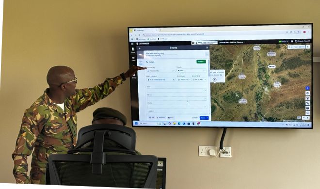
Earth ranger in use at the Mara-Serengeti Ecosystem
CCF
A visualisation platform for real-time protected area management, helping managers make informed, conservation-related operational decisions. A community of users is now sharing best practices and innovative concepts, engaging EarthRanger as it extends beyond just elephant protection to a diversity of wildlife, ecological and community applications.
CCF has a long-term partnership with the AI2 Team, which developed this software.
Data flows seamlessly from field-based hardware through the network into Earth Ranger
Diagnostic information is key to good support and maintenance.
Transporting data from the field to the operations room
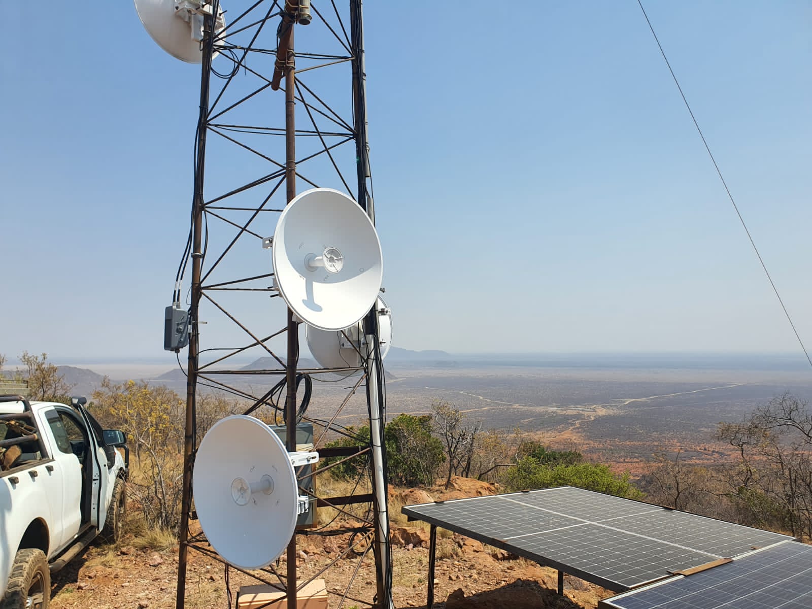
Cisco LoRa gateways enable low-power, long range sensors
Madikwe Futures Company
From soil moisture and water levels to animal migrations and habitat health, data from sensors travels via Cisco LoRaWAN gateways and Actility’s ThingPark™ Platform to central operations rooms, where platforms like EarthRanger provide a comprehensive 360-degree view of ecosystem health and threats. Previously, these have been donated by Cisco Inc. These LoRaWan gateways now support over 800 IoT sensors across protected areas.
When using LoRaWAN, data is transmitted wirelessly to a gateway. The gateway listens for the corresponding signals and transmits them to a LoRaWAN network server, which is connected to the Internet.
Deploying a LoRaWAN network is quicker and much more accessible than setting up a conventional cellular system.
Operation requires minimal infrastructure. Setting up cables and making connections to the power line is not required. Network design and optimisation are also simplified, as with one gateway, you can cover a larger area very effectively.
Reliable and long-term : The gateways are robust and come with a 7-year warranty, offering peace of mind and operational security for protected area managers working in harsh and remote conditions.
Unmatched coverage in rugged terrain: LoRaWAN technology continues to outperform alternatives in remote and rugged landscapes, providing extensive and reliable coverage across challenging terrain where cellular connectivity is limited or non-existent.
Seamless regional asset tracking: The system supports device roaming, allowing for uninterrupted tracking of assets across different regions without manual reconfiguration—an essential feature for mobile wildlife monitoring and conservation equipment.
Cost-effective: By leveraging low-cost, commodity-based hardware and integrating standard radio modules, LoRaWAN devices reduce overall deployment costs significantly. Compared to cellular or Wi-Fi-based solutions, this makes wide-area sensor networks more financially accessible for conservation teams.
A scalable and sustainable alternative: With its low power consumption, long range and minimal infrastructure needs, LoRaWAN provides a sustainable alternative to satellite communication. It enables real-time environmental monitoring in even the most isolated locations.
Widespread adoption for Conservation: Outside of this partnership, over 200 protected areas across the country are now using LoRaWAN to monitor vital resources like water, food, and habitat health. This growing adoption is helping secure a resilient future for wildlife, ecosystems, and the communities that depend on them.
Actility LoRaWAN Things Park Network ServerThe network server connects sensors, gateways and end-user applications and ensures reliable and secure data routing all along the LoRaWAN network. Along with the Operation Support System (or OSS), they are the brain that controls the complete LoRaWAN network
Collects data from the LoRaWan Gateways and transports this data from field-based sensors onto Node Red, which sends data to Earth Ranger (a data visualisation software).
It can be self-managed through training.
It is easy to replicable.
It can be deployed on-premise or on the cloud
Today, Actility’s IoT network server supports 131 LoRaWAN gateways with CCF and nearly a thousand sensors across 35 community-led and private conservancies. These networks span iconic landscapes like the Masai Mara, Tsavo and Northern Rangelands of Kenya, forming a digital safety net across nearly 10 million hectares.
Government agencies, including the Kenya Wildlife Service and Uganda Wildlife Authority, have endorsed the LoRaWan approach for expansion across national parks and community lands.