Partnership and meaningful stakeholder engagement
During the first year of the project, we developed a partnership with a range of groups and individuals interested in economic valuation and marine conservation in Belize. Our core partners were WWF-Central America and World Conservation Society, but we also worked with more than 10 Belizean NGOs, MPA co-managing organizations, and government departments, as well as faculty at Belize’s universities. We held a workshop in Belize in 2007 to introduce economic valuation and held several follow-up workshops in the following year, focusing separately on shoreline protection, fisheries, and tourism in greater depth. The project partnership represented the views and expertise of a wide range of primary, secondary, and external stakeholders. The partnership was instrumental in helping design the valuation study, identify potential policy applications and outreach opportunities, collect data, and communicate results to decision makers.
• Time and resources dedicated to building and communicating with partnership • Previous experience and partnerships/relationships in Belize • Open communication and mutual respect
The positive results of working very closely with our partners on policy applications in Belize reinforced the lesson that early and frequent contact with knowledgeable partners is crucial to producing useful results and supporting conservation and sustainable development outcomes.
Collection of environmental/socioeconomic information
Working with partners, we gathered data on reef- and mangrove-associated tourism, fisheries, and shoreline protection from a variety of sources (mostly sources in Belize): - Tourism: data on accommodation from the Belize Tourism Board, scaled by the percentage of tourists who are reef- or mangrove-associated (determined via expert opinion in each district), data on reef and mangrove recreation and cruise tourism from the Belize Tourism Board - Fisheries: data on catch from Fishermen’s Cooperatives, divided into (1) exports through cooperatives, (2) local sales through cooperatives, (3) all other local sales - Shoreline protection: a variety of spatial data sets were collected, including data on coastline (SERVIR), elevation (NASA Shuttle Radar Topography Mission 90m DEM), coral reefs (Belize Tropical Forest Studies Ecosystem Map, Wildlife Conservation Society, Belize Coastal Zone Management Authority and Institute), mangroves (Belize Forestry Department, LANDSAT), coastal geology, coral characteristics, storm regime, and coastal property values (internet search).
- Knowledge on how to develop a sensible model and data needs - Engaged partners who identify the best sources and facilitate data transfer
We were somewhat surprised at how difficult the data collection process was for Belize, both at the national and MPA levels. This led us to encourage improvements in data collection and record keeping (some of which have been adopted) by MPAs, the Fisheries Department, and the Belize Tourism Board. It also led us to re-consider using alternative valuation approaches, including survey-based methods, going forward – especially since Belize may well have much better data than some other countries in the region.
Public consultation on draft reports
Throughout the assessment process, the Authority consulted with its expert and community advisory groups. There were also opportunities for input from broader Traditional Owner and stakeholder groups through purpose-designed workshops and follow-up surveys, plus meetings with a range of interested organisations, groups and individuals. Public consultation on the draft strategic assessment and program reports for both the Region and the coastal zone took place over a three-month period from November 2013. Comments received through these processes were incorporated into final reports and detailed in supplementary reports.
Contact solution provider for more information
The importance of relying on best available information, including scientific data, expert opinion, and Traditional Owner and stakeholder knowledge.
Establishment of plot rendering
Plot rendering is based on a strong partnership between a municipality, the association of farmers in the county (or pastoral Group) and the Pyrenees National Park. The town, which owns the land, extends and provides the plot. The Pastoral Group is responsible for the plot. It supplies the plot with dead carcasses naturally in its operations, and cleans it regularly. The Pyrenees National Park follows the population of vultures, initiated the project, and technically and financially supports the development of the plot.
The ongoing dialogue between all partners (community, pastoralists, government agencies and National Park) has clarified the need for health monitoring and identified constraints to take into account when planning the plot. The establishment of this plot, accepted by all partners and managed efficiently, took nine months of negotiations. French regulations strongly regulate the fate of animal carcasses. One key to the success of this project lies in the support of the state and taking into account the population of vultures in this area.
The local context of interactions between livestock and vultures was complicated, with several complaints about interventions of vultures with livestock. The 9 months of project development have highlighted the fact that it is essential to rely on an existing group. It would have been unrealistic to create the breeders’ association to manage the plot rendering. This is the first plot in France managed by a group of farmers. The plots are highly regulated (type and quantity of deposits, health monitoring ...), and collective responsibility can be cause for concern. In this case, although adjustments were necessary, the empowerment of actors has been a success. The last lesson of the project was the strong involvement of the community, the services of the State and National Park, otherwise the project would not have succeeded.
National upscaling and transboundary exchanges
Building this project within a larger regional project (incl. Thailand and Vietnam), enables the sharing of experiences among countries (fisheries market development, coastal protection) and facilitates the understanding of climate change as a global concern with localized solutions. Collection of effective solutions, good practices and lessons learned are shared at regional level under a regional platform. High level national officials are involved in field visits and local discussions to bring community-led examples of climate change adaptation to national attention.
The participation of some national government representatives was a guarantee to bringing local examples to a national platform. Good communications and information sharing about data on the status of biodiversity and climate is a pre-requisite for conservationists and policy makers to make an informed and right decisions for the conservation and management.
Exchange of site visit by local communities and local media to the neighboring countries is also a good strategy for allowing them to learn about the issues in terms of biodiversity protection and conservation, climate change issues and local adaptation and local response mechanisms. In addition, they can share successful and unsuccessful lessons learned and best practices which can be applied in their localities. In addition to this, media can also play an important role in disseminating issues about climate change and local solutions to the wider audience. Sanctuary zoning with clear zones of core zone, conservation zone, multiple use zone and community use zone and signed by the prime ministerial sub-decree is a model for other protected areas and countries to follow. It restricts the attempts by private companies to obtain economic concessions from the government.
Designing the fund’s structure and governance
In this stage the water fund’s structure and each stakeholder’s responsibilities are determined. A contract signed by the partners serves to formalize their agreement to unite efforts to carry out watershed conservation activities. It is also a guarantee to third parties wishing to contribute financial resources. Negotiating the contract must comply with fundamental legal requirements and corporate purpose of each partner, and must possibly be overseen by a specialized law firm. The fund’s board of directors will be responsible for overseeing the decision-making process. Therefore, it is crucial to prepare internal guidelines outlining the board’s operations, including e.g. decision-making mechanisms. A voting mechanism should be defined to guarantee the balance between the public and private sector, ensuring that decisions are reached in a consensual, independent and transparent manner. Prior to launch, the strategic plan (Goals; Priority Areas for Conservation; Cost Analysis of the Activities to be Implemented and Design of Financial Flow; Strategic Plan Preparation; Preparing Financial Flow) and fundraising strategy need to be designed.
Solid science and technical studies. Understanding of tradeoffs and willingness to compromise
Creating a water fund does not necessarily mean the creation of a new organization. Although this may be a solution to overcome legal obstacles, it is important to optimize resources and the use of partners’ available technical capacity, in order to avoid creating new legal bodies. The water fund’s investment decisions must be made in consensus and with transparency. The design of the investment plan and of a fundraising strategy must go hand-in-hand. The latter specifies expected incoming funds, to finance priority conservation activities, but also to establish own capital in order to be autonomous in the long term. The creation and operation of a water fund is an adaptive process that requires modifications, adjusting goals and continuous improvement, especially because many financial, social and political issues may vary from the initially approved investment plan.
Working with the best available information/knowledge

When undertaking a planning or zoning task, rarely does a planner have access to all the information or knowledge that they would like for the entire planning area. Whether it might be more consistent ecological data across the entire planning area or a more complete understanding of the full range of social and economic information, a planner is often faced with the following choices:

  1. Waiting until they have more data (with the ultimate aim of accumulating ‘perfect’ information across all the required datasets); or
  2. Working with the best available scientific knowledge and accepting that while it is not perfect, it is adequate provided the deficiencies of the data are understood (by the planners and the decision-makers) and clearly explained to the public and to the decision-makers. Insufficient knowledge about marine ecosystems can impede the setting of meaningful objectives or desirable outcomes when planning. David Suzuki in 2002 questioned how can we effectively plan and manage when “… to date all we have actually identified are ... about 10–20% of all living things”, and “… we have such a poor inventory of the constituents and a virtually useless blueprint of how all the components interact?’’

A good understanding of the wider context within which the MPA is situated is an important factor when planning. Due to the levels of ‘connectivity’ in the marine environment and the biological interdependency upon neighbouring communities, an MPA can only be as ‘healthy’ as the surrounding waters. Even a well-planned MPA will be difficult to manage if the surrounding waters are over-utilised, polluted or are themselves inadequately managed.

  1. The reality is if you wait until you have ‘perfect’ information for planning, you will never start.
  2. Recognise that marine areas are dynamic and are always changing; and with technological advances, the levels and patterns of use are constantly changing, as are the social, economic and political contexts, so having perfect data is realistically an impossible aim.
  3. In virtually all planning situations, it is better to proceed with the best available information than to wait for ‘perfect’ data. However, if new data becomes available during the planning process, then incorporate it rather than ignore it.
  4. Those who are frequently on the water (like fishers and tourist operators) often know as much (if not more) about the local environment than the researchers – so draw upon their knowledge and use it to augment the best available scientific data.
  5. When resources are limited, seeking new data should focus on providing information that will be useful for ongoing management.
Multiple-use zoning

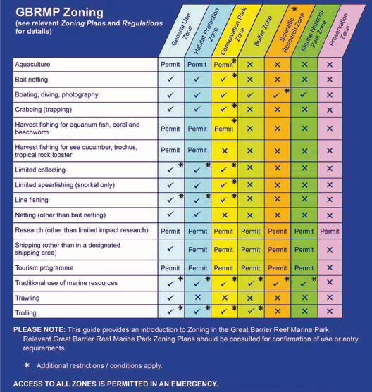
In some parts of the world, zoning is based solely around allowing, or prohibiting, specific activities in specific areas. In the GBR a spectrum of zones exists, each with differing zone objectives; these zones allow a range of activities to occur provided each activity complies with the relevant zone objective. The provisions of the Zoning Plan apply to all users in the GBR. The Zoning Plan sets out in detail two specific lists of ‘use or entry’ provisions for each zone; these help determine the types of activities that are appropriate in that particular zone. 1. The first list indicates activities that are allowed to occur in that zone (‘as of right’) and which do not require a permit; 2. The second list stipulates which activities may occur in that particular zone but only after a permit has been assessed and, if the application meets all the necessary requirements, a permit has been granted. The regulations specify the assessment process and criteria for a permit; these vary depending on the proposed activity. Some zones may also stipulate restrictions on types of fishing gear which also provides differing levels of protection. If an activity is not listed in either (1) or (2) above, it is prohibited in that zone.

The 1975 legislation specified that a plan depicting spatially derived zones (i.e. zoning) was to be a key management tool for the GBR Marine Park, and zoning plans were required by the legislation to define the purposes for which certain areas may be used or entered. The objectives of zoning have ‘evolved’ since the 1975 version of the Act (refer Day 2015) recognizing a need today to protect the full range of the biodiversity of the GBR rather than just keystone species or habitats.

  1. To assist public understanding, the allowable activities in the Zoning Plan have been summarized into a simple activity/zoning matrix (see Photos below). However, the statutory Zoning Plan (i.e. subordinate legislation under the Act) must be the legal basis for determining which activities are appropriate in a zone.
  2. Zoning maps are a publicly-available form of the statutory Zoning Plan; however, to legally determine exactly where a zone boundary occurs, the actual zone descriptions detailed in the back of the statutory Zoning Plan must be used.
  3. Just because the Zoning Plan states an activity is able to occur with a permit, it does not automatically mean a permit will always be granted; the application still needs to be assessed and only if it meets all the necessary criteria, is a permit granted.
Relevance of international conventions for MPA management
Australia is a signatory to a wide range of international conventions/frameworks relevant to MPAs; the main ones are listed in Resources below and include global and regional conventions and treaties as well as bilateral agreements. The fundamental basis for international law and conventions is mutual respect and recognition of the laws and executive Acts of other state parties. • Note the term ‘state party’ is used in many international conventions instead of ‘nation’ or ‘country’ – but don’t confuse the term with federal states or territories. Some of the obligations arising from these international conventions have been incorporated into Australian domestic law (e.g. some provisions of key international Conventions addressing significant matters such as World Heritage, are incorporated into Australia’s national environmental legislation, the Environment Protection and Biodiversity Conservation Act 1999). How much international conventions impact on various countries will vary according to the regulatory, legal and political context of the country in question, whether that country is a party to the relevant conventions or agreements, and whether these have been implemented at the national level.
• The range of international instruments, in conjunction with domestic (national) legislation and to a lesser extent, Queensland (State) legislation, collectively give the GBR very strong legal protection. • International law may be relevant to interpreting domestic (national) legislation and may assist if there is an ambiguity in domestic law.
• Once a country has signed and ratified an international convention, there are international obligations with which that country must comply; however, enforcement of non-compliant nations by the global community is not easy. • The level and detail of reporting on international obligations varies; some examples are shown in ‘Resources’ below. • The ‘precautionary approach’ has become widely accepted as a fundamental principle of international environmental law and is now widely reflected in Australian environmental law and policy. • Some of the issues facing coral reefs, such as climate change, are global or trans-boundary and are addressed in international conventions – however while those issues may be global, many also require local level solutions for effective implementation.
Complementary legislation
Complementary legislation refers to laws that complement or supplement each other, applying matching or ‘mirrored’ provisions to enhance public understanding or enhance the mutual strengths of the laws. The reasons why complementary management is essential in the GBR is outlined under ‘Impact’ for this Blue Solution, including the fact that the State and federal governments cannot agree where the boundary occurs between their respective jurisdictions. The Zoning Plan for the federal Marine Park was revised from 1999-2003 and came into effect on 1 July 2004. To ensure complementarity and to minimise public confusion, the State of Queensland declared the Great Barrier Reef Coast Marine Park in November 2004. The zoning for this Coast Marine Park mirrors the adjoining federal zoning by providing complementary rules and regulations between high water and low water, all along the mainland adjoining the GBR and around all Queensland islands within the outer boundaries of the federal Marine Park. Complementary zoning means that activities that can be undertaken within the two Marine Parks are governed by the same regulations; however, there are also some Queensland specific provisions that may apply only in the GBR Coast Marine Park.
• The Australian Constitution states when a State law is inconsistent with a federal law, then the federal law shall prevail; the State law is, to the extent of the inconsistency, invalid. • Section 2A(3f) of the GBRMP Act requires “... a collaborative approach to management of the GBR World Heritage area with the Queensland government”. • The 1979 intergovernmental agreement agreed on a complementary approach which subsequently aided the evolution of effective complementary legal instruments.
• Complementary legislation ensures a workable solution so that all marine waters seaward of the Highest Astronomical Tide are effectively under the same rules and regulations, irrespective of the jurisdiction in which they occur. • Using complementary legislation for policy is far more effective than having slightly differing interpretations for adjoining areas or similar provisions drafted in a way that allows differing interpretations. • A complementary approach is more holistic and effective for the following reasons: - ecologically: it recognises temporal/spatial scales at which ecological systems operate (rather than the inadequacies of jurisdictional boundaries) - practically: it is easier to manage, ensuring that matters do not slip through ‘unforeseen regulatory cracks’; and - socially: it helps with public understanding and hence compliance. • To ensure a complementary approach, officers in both governments cooperate when developing policies.