Early warning system

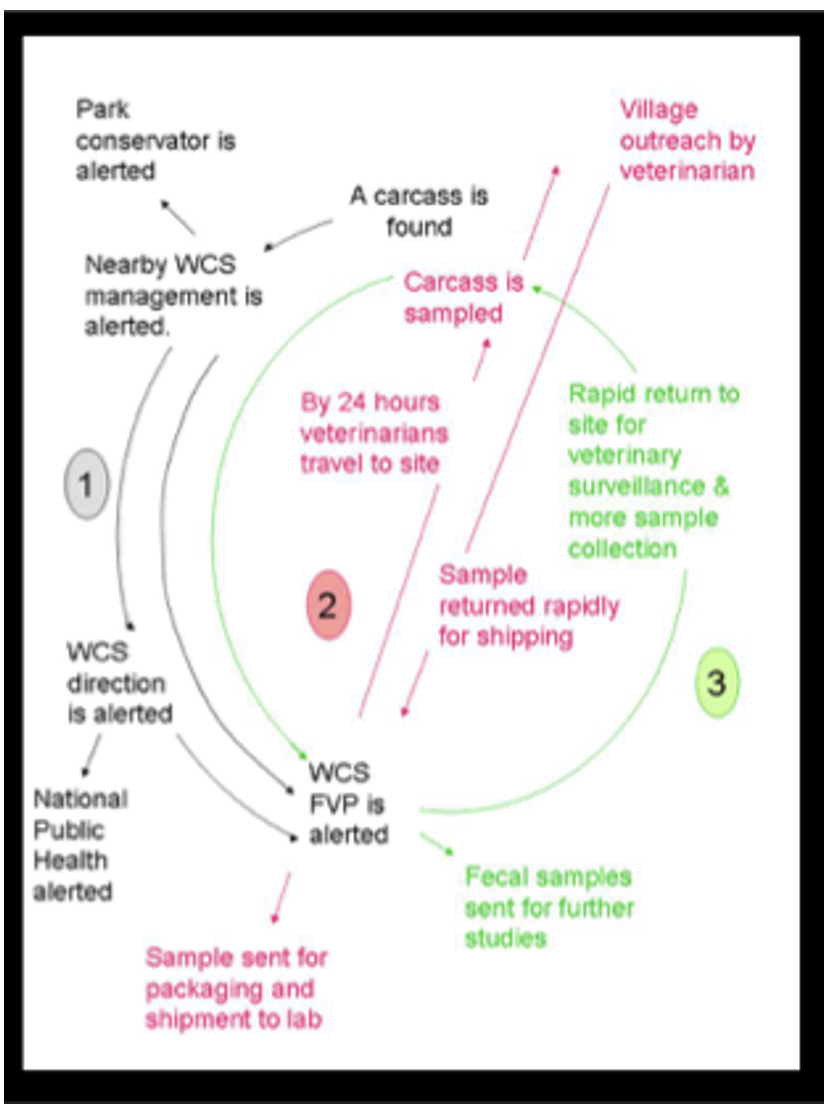
Components of the system involved mortality reporting by hunters and community members, investigation of reports by veterinarians trained on specimen collection and handling protocols, specimen transport to national laboratories, and laboratory screening for disease diagnostics. Each of these involved specialized inputs, but the coordination between entities created the system. Information management and communication were conducted throughout the process. A Carcass Data Collection and Reporting Protocol was integral to the process, ensuring consistent reporting.

  • A local team, supported by a global program, ensured continuity of the broader Animal Mortality Monitoring Network and technical expertise to develop and implement disease investigation protocols
  • Full integration and support of Congolese government officials from multiple ministries helped prioritize the animal-human link for public health and conservation outcomes
  • Availability of functional national and international laboratories and the ability to move specimens rapidly, including from remote areas, supported diagnostics in endangered species

In this setting, hunters and some community members were the key eyes on the ground for wild animal mortality detection, having some of the only human presence in forest areas where carcasses may degrade rapidly, providing a limited window for detection and investigation. While the overall Animal Mortality Monitoring Network included a broader scope of reporting, only reports meeting certain criteria (such as being a great ape species, the extent of carcass degradation, and other factors) prompted disease investigation, keeping the scale of the program feasible and cost-effective. Unfortunately, despite its demonstrated value, sentinel detection in wild animals is not routinely a formal part of public and animal health surveillance in many parts of the world, missing a critical source of potential information that could promote early warning for disease threats in humans and other species. Training was also an important component of the project, including on biosafety protocols for safe disease investigation and diagnostic screening.

Coordination Platform for Sustainable Pasture Management

A Pasture Coordination Platform was organized in Armenia as a horizontal management network among relevant stakeholders on national and sub-national level. Each party is represented by a spokesperson, who coordinates the functions of the party within the Platform and ensures information flow. A secretariat ensures the operation of the Platform. The rationale for creation of the Platform was the need to promote effective cooperation, exchange of information, as well as coordination of activities among the projects implemented in Armenia, focusing on sustainable management of natural fodder areas.


Since 2018 the Platform has evolved and now more than 10 organizations, institutions, projects and public administration bodies are involved in the Platform’s activities, aiming to ensure viability of programs and investments in the area of animal farming, increase economic opportunities of communities and support income growth of rural residents in Armenia. Key objectives of the Coordination Platform are:


  • Coordination, exchange of information exchange and experience, identification of potential cooperation areas
  • Implementation of joint projects, activities
  • Advocating and supporting development of relevant state policy and legislation promoting sustainable use and management of natural fodder areas


  • The platform has a clear aim: "to improve the situation/ livelihood of the rural population which depends on natural fodder areas while sustainably using and conserving these natural ecosystems”.  

  • The need for coordination, cooperation and exchange was felt by parties both from government as well as non-government organizations. 

  • A memorandum was officially signed to establish the platform. 

  • All members have clearly distinguished functions. 

  • Active participation of the community stakeholders in decision making and coordination of the local projects was crucial. Placing the local working groups in charge of the local implementation not only generated a high level of ownership of the project and ensured the engagement of the community.  

  • The coordination with other development organizations on the local scale was a key factor. The harmonization of these different local interventions resulted in a comprehensive, positive change for the communities. Each intervention was complimented by the others and would not have achieved the same results as an isolated activity. 

  • Based on the memorandum of understanding, the common interest and need of all stakeholders in the platform to cooperate increased their commitment and ensured the continuity of the process. 

  • Multi stakeholder advisory bodies face high risks from unforeseen changes in governmental institutions or even within their own parties. The meticulous documentation of agreements and activities has proven to be an important measure for dealing with this risk.  

GIS and Remote Sensing for mapping pasture areas

Maintaining pastures as a natural resource is easily to been done by the application of GIS and remote sensing tools to develop accurate classification maps, e.g. pastures, hay meadows, grassland. The combination of digital data and spatial technology enables detailed and useful monitoring of aboveground green vegetation biomass and grassland composition. Besides, resources and attributes can be monitored for knowledge management and long-term decision planning.  

  • Mapping of pasture/ grassland ecosystem services and understanding of its contribution to human well-being  

  • Facilitate regular monitoring at the management level 

  • Short-term study of the positive and negative effects on pasture or grassland areas 

  • Existence of relevant legal bases and close involvement of relevant bodies in the planning process 

  • All factors that may affect pastures should be identified as spatial data 

  • Mapping and monitoring changes in grassland vegetation cover is essential to understand grasslands dynamics 

  • Reliable monitoring of changes in vegetation cover in grasslands is crucial for accurate and sustainable land management 

  • Gathering more field/ ground truthing data was one of the important notes 

  • It is vital to test and demonstrate different geospatial analyses to showcase what measures have the most impact on which erosion/degredadion situations and foster understanding for the solutions. 

Community prosperity through developing nature-based tourism

The well-being of the communities close to the parks is essential for the success of our strategy. Complete, functioning and healthy ecosystems will not only assure important environmental services like clean water, clean air and the mitigation of floods, but they also offer new opportunities to develop sustainable economies.

These areas usually have great potential, but they also face important threats. The ecosystems are usually degraded and are not considered locally as a source of opportunity or income. Also, these places on the edges of protected areas usually have populations with high level of poverty and high rates of out-migration to big cities.

We work along with these communities to create a path to a new sustainable economy, directly linked to opportunities that come from the creation of new protected areas and to the return of wildlife. We act to empower community leaders and women, strengthen the connection of the youth to their homeland and their environment, train people in new trades and build relationships based on trust and respect.

Work together with local communities and local, provincial and national governments in the development of tourism “circuits” that offer spectacular landscape as well as wildlife-viewing experiences, at gateways, or entrances, to the protected areas or parks. 

Empower and build the capacity of local entrepreneurs with trainings and workshops, so that they can be the first to benefit from these new activities based on wildlife and nature. Finally, promote these destinations and experiences to a broad public to attract tourists.

Nature-based tourism has been growing globally at rates of more than 4% per year, particularly in low- and middle-income countries. Charismatic fauna, including large predators, are becoming increasingly important. In the Brazilian Pantanal, the world’s largest wetland, wildlife viewing — mostly of jaguars — generated an annual revenue millions of dollars per year; many times the revenue obtained from traditional cattle ranching in that region. 
Large Parks creation

The national and provincial parks are public spaces that have the most effective legal protection for the conservation of biodiversity. It is for this reason that our organization strives to acquire and donate land to the nation and to the provinces to create parks. Ours is an unprecedented process whereby large private areas of land, that were degraded and closed to the public, are restored and passed into the hands of the State, and are open to all to be visited and enjoyed.

These spaces invite us to connect with nature through wildlife watching and other outdoor experiences.

- Large portions of preserved natural ecosystems, either already public or private that could be acquired.

-Public authorities understanding the need to create protected areas, both by the beneffits to nature and to people through a healthy ecosystem and economical beneffits from ecotourism development

-Public access to guarantee the visitation of these areas

Additionally, we found that relating the creation of parks to local development is a useful way to gain support from politicians, top-level decision-makers and neighbors. We discovered that, in order to make the public feel as part of the project and protected areas, we needed to acknowledge their role and impact on the program’s results. In this way, people felt like active participants in teh creation of protected areas, species recovery, adopting and supporting the project’s goals.
 

Networking and Capacity Building of Volunteers for Dugong Rescue and Release (Since 2016)

OMCAR signed MoU with government institutions (Wild Life Institute of India and Sacon) to work with other stakeholders efficiently and quickly respond to the dugong rescue and release in Palk Bay. With the partnership of Tamil Nadu Forest Department and Wild Life Institute of India, OMCAR established “Friends of Dugongs” in every fisher village in northern Palk Bay. The volunteers were trained to respond to a dugong strandings, and how to organise rescue and release with forest department. The volunteers have been actively supporting to share the information about dugong sightings, rescued and released dugongs in the past six years. As a result, several dugongs have been rescued and released in Palk Bay, and fishers received rewards and honoured by government. OMCAR published its stranded marine mammals record in a scientific journal, which helped as evidence for the need for the establishment of conservation reserve. 

  • The signing of the Memorandum of Understanding with Government institutions helped to build a strong partnership.


  • The capacity building of volunteers from the fishing community enabled the successful rescue and release of dugongs from fishing nets.


  • Recognition and rewards received by fishermen, who rescued and released the dugongs created a positive encouragement.  


  • Publication of dugong strandings supported the establishment of a dugong conservation reserve in Palk Bay.
  • Grassroot conservation needs cooperation and mutual support from the government, NGOs, the public, and research institutions.


  • Immediate response for the stranded dugongs, rescue, and release work with the participation of volunteers from coastal villages was possible through social media networking.  


  • Encouraging the community volunteers helped to enhance the dugong conservation further.


  • Scientific publications and documentation are important for NGOs working in grassroots conservation. 


Developing Participatory, Eco-friendly and Low-cost Seagrass restoration method (2016 - 2022)

Restoration of seagrass beds is different from the restoration of terrestrial plants, as it needs to work underwater ecosystem. Seagrasses reproduce through sexual reproduction and vegetative reproduction. In seagrass restoration, the seagrass sprigs were removed from the donor site and transplanted to degraded sites. There were already established methods obtained from scientific publications using 1m2 PVC frames for transplanting seagrasses. Although this method is successful, we determined not to use the PVC plastics that need to be permanently fixed on the seafloor for seagrass restoration. So, OMCAR discussed with local fishers to develop an eco-friendly, low-cost method for seagrass restoration. For the first time in India, we used bamboo frames and coconut rope frames as an eco-friendly frames for fixing the transplanted seagrass sprigs from healthy sites to degraded sites. Local fishers were trained and involved in the seagrass restoration work. As both bamboo and coir ropes are available locally, they are cost-effective, and they can be presently fixed on the seafloor until they get degraded naturally. This method is now being adapted and replicated by the government for seagrass restoration in other areas of Palk Bay and the Gulf of Mannar. 

  • The participatory seagrass restoration procedure is the key strength of this method, which is developed by OMCAR with the consultation of fisherfolks.
  • Bamboo and coconut coir ropes are degradable, so they will not pollute the sea like PVC frames.
  • Bamboo and Coconut coir ropes are locally available, so they are low-cost to be used in large-scale participatory seagrass restoration.
  • The results of this project have been published in a scientific journal.


  • Eco-friendly restoration method ensures the sustainability and recognition of the government.


  • Participation of the local community in seagrass restoration methods increases their sense of responsibility.


  • Locally available raw materials reduce the cost of the restoration accessories while reducing the use of plastics.


Providing Technical support for Planning Dugong Conservation Reserve in Palk Bay (2017 - 2022)

With the partnership of Wild Life Institute of India, OMCAR has been providing technical support to the Forest department in Pudukkottai and Thanjavur district for creating the boundary of dugong conservation reserve based on our published acoustic survey results from NRDMS, Department of Science and Technology project. OMCAR experts had been working with frontline staff, district forest office, and Conservator office for developing the plan, GIS mapping of the dugong conservation reserve, and by sharing the data of its 12 years of marine mammal stranding observations in northern Palk Bay. 

  • Technical expertise within the organization and willing to volunteer at the government offices at any time.
  • Published papers in scientific journals, data, photographs of dugong strandings, and seagrass acoustic survey.
  • Partnership with Wild Life Institute of India through MoU helped to work together for the common goal of supporting the forest department in establishing the dugong conservation reserve in Palk Bay. 


  • Persistence and patience are important when working with multiple stakeholders for long-term conservation goals.
  • Each stakeholder has their own official working methods, and limitations, but at the same time, they have a specific capacity to contribute to the conservation of dugongs and seagrass beds. 
  • As a grassroots NGO, servant leadership will work when working with multiple stakeholders for the conservation goal.


Technical Training for Seagrass Restoration and Dugong Rescue and Release for Forest Department (Since 2017)

After a decade of technical and in-situ conservation experience in dugongs and seagrasses, OMCAR received recognition from Tamil Nadu Government to organize technical orientation sessions for the newly recruited trainees of Range Officers, Foresters, and Guards at our center. Since 2017, our organization received about 2500 trainees of Tamil Nadu Forest Academy cadres for organizing training sessions. Our team shares explain of the seagrass acoustic mapping methodology, seagrass restoration methods using eco-friendly cost-effective materials, how to rescue and release the dugongs, and how the networking and capacity building of fisher volunteers is effective in the conservation of dugongs, and restoration of seagrass beds. OMCAR has been providing this service on a nonprofit basis.

  • Technical knowledge of eco-friendly and low-cost seagrass restoration methods in our team.
  • Technical knowledge on seagrass mapping using acoustic technology in our team.
  • Experience in networking and enabling the volunteer network for responding to dugong strandings, rescue, and release.
  • Long-term efforts in developing grassroots conservation techniques can be recognized and benefit the Government. 
  • Technical expertise and experience are invaluable assets for grassroots conservation organizations. 


Participatory Survey for Mapping Seagrass Beds in northern Palk Bay (2010 - 2017)

Before this survey, there was no accurate scientific data available about the extension of seagrass beds in northern Palk Bay. The preparation started in 2010, and the actual survey started in 2013 and was published in 2018. We had to come across issues related to funding, logistics, and how to build technical knowledge within our organization. Due to poor water quality, it was difficult to map the seagrass beds using satellite imagery. So, OMCAR built a survey boat (a modified fishing boat), developed skills in GIS and acoustic methods, and scuba equipment from 2010 to 2013. With the funding from NRDMS, DST, Government of India – OMCAR started to conduct the acoustic survey in shallow nearshore waters in northern Palk Bay for proposing the site as a conservation reserve.  This was the first such attempt to survey the seagrass beds using acoustic technology in India. The final reports were submitted to Government and also published in 2018. This baseline survey revealed the distribution of seagrass beds in the ‘dugong conservation reserve’ up to 35,000 hectares of northern Palk Bay, so 500 square kilometers area in and around this seagrass bed has been selected to be declared as a” Dugong Conservation Reserve” based on this research by Government. 

Our team consists of a marine biologist (founder of OMCAR), staff, and volunteers from the local community. This enabled us to plan for the seagrass survey methods using both scientific and traditional knowledge. 
Low-cost navigational devices were assembled for this survey to navigate the boat perpendicular to the coast along the transects. 
Local fishers who attended our capacity building training have helped with their traditional knowledge for planning suitable months and time to carry out the seagrass survey.

  • Seagrass acoustic survey can provide accurate, local-based information about the distribution of seagrass meadows for conservation planning.  
  • Local people's participation and support are important, which will help for the safety of the survey crew, and the selection of suitable months and time for the survey.
  • As the results are important as evidence to prove the total area of seagrass beds for declaring the protected site, technical knowledge, and dedicated staff are essential. 
  • Training and capacity building of local volunteers from the fishing community is important for participatory seagrass surveys.