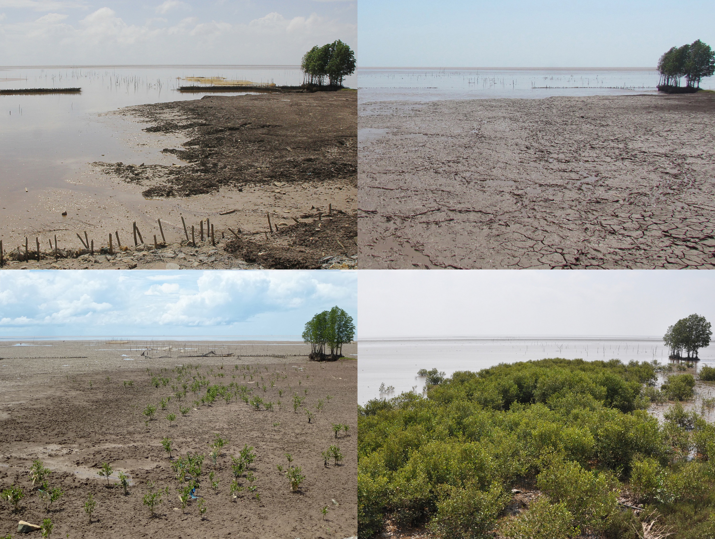
Mangrove protection and planting

Bamboo T-fences are used to restore eroded floodplains and the fine sediment balance as a precondition for natural regeneration of mangroves forests – the latter will then form part of an effective area coastal protection strategy. After successful restoration of sites suitable for mangrove growth, natural regeneration of mangroves will occur. It is, however, essential that the mangroves are protected from human impacts, otherwise the cycle of degradation/destruction and expensive restoration will continue uninterrupted (see illustration under "How do the building blocks interact in the solution?"). This can best be achieved by involving local people in effective protection and management of mangroves through co-management. For more information see solution “Co-management (shared governance) of natural resources in the coastal area”. If rates of natural regeneration are insufficient, supplementary planting of mangroves may be necessary. In such cases, appropriate species need to be planted at the right sites at the correct time.

• Decision-makers understand coastal processes and mangrove ecology. • All stakeholders are willing to engage in shared governance (co-management) of mangroves.

Co-management, or shared governance, is an approach for sustainable and effective mangrove protection and management. It also provides livelihood for local people and contributes to better governance of natural resources. The results of the fixed-point photo monitoring from the coast of Soc Trang Province (Vietnam) from Nov. 2012 until Jan. 2015 clearly show the impacts of T-fences on sedimentation and, as a result, on natural regeneration of mangroves. Mangrove foresters need a sound understanding of mangrove ecology and of coastal processes and morphodynamics. The most effective way of planting mangroves is to learn from nature, i.e. mimic how nature plants, which species nature plants and the way nature creates a species zonation. This zonation leads to optimised coastal protection through wave attenuation by above-ground root structures along with soil stabilisation by below-ground root structures (see illustration in "How do the building blocks interact in the solution?").

Planning and construction of breakwaters

Physical models determine the optimal design of the actual breakwaters. The strength of the bamboo poles was tested during field testing of the fences. Durability information of bamboo is derived from experiences using bamboo in Thailand. Local people are informed of and engaged in the planned activity. With technical support, local people construct breakwaters, i.e. T-shaped fences from natural materials (bamboo). Permeable T-fences do not inhibit sediment input and create calm water conditions for sediment deposition. The long-shore parts break the waves and the cross-shore elements catch sediments suspended in long-shore currents. The gaps in the long-shore parts improve sediment input into the fields created by the fences during flood tide, while drainage is accelerated through the openings during ebb tide, thereby accelerating the soil consolidation process in the fields.

Successful design and construction depend on results from numerical modelling, observations from coastline changes, records of erosion and sound execution of T-fence construction and construction supervision.


The following boundary conditions must be fulfilled to ensure that the fences are effective:

  • Muddy environment; medium grain size diameter of top layer of the mud d50 < 0.03 mm
  • Significant wave height Hs < 0.90 m
  • Mean wave period Tm < 8 s
  • Small gradient of the tidal flat < 1:1000
  • Clearance of the crest of the construction < 1.40 m

Involvement of technical departments and local authorities and people in the planning, design and construction process was important to ensure acceptance, support, long-term commitment and ownership. The most effective way to restore eroded foreshores is to use permeable t-fences which create calm water conditions for sediment deposition and reduce erosion. Construction of the T-fences must follow quality standards and must be well supervised. This cost-effective approach will only be feasible within a specific set of boundary conditions (see graphic below). If these limiting criteria are exceeded to only a small extent, adaptations such as strengthening the fence with concrete poles must be considered. If the limiting criteria are exceeded to a large extent, use of T-fences is not feasible. Other factors to be considered are location of the fences to minimise lee erosion, as well as proximity to the shoreline and length of submergence periods to minimise damage by shipworms. The duration of submergence and exposure to waves also affect the effort required for maintenance.

Experiences and practices documentation

A technical team developed the methodology and instruments to collect, organize and asses the information. It included guidance for data collectors, a format to download the information, forms to obtain authorization to publish the answers and pictures of the best practices. Technical institute students were trained in using and testing the data collection instruments. A local environmental NGO focused on the northern section of the State, where they interviewed managers of large tourism corporations and developments, based upon the NGO’s long-term relationship with the tourism industry. The technical institute focused on the southern section of the state and interviewed small-scale hotels and houses owners in coastal communities. The technical institute built a database with the information from both areas. The database was thoroughly revised by the technical team and then revised by local experts (architects, engineers, biologists, oceanographers) in workshops, via email and personal interviews organized by the three organizations.

Experts were highly interested, and dedicated quality time to the revision, recognizing the importance of the catalog which resulted from their early involvement in the process. As an academic institution, the technical institute organized a group of dedicated students along with multidisciplinary faculty to conduct the survey and revisions in the southern area, while building capacities in the process.

Devoting enough time to develop the instruments and testing them was crucial for successful data collection. The team did not have to go back to collect further information. Ensuring enough funding and time for all project phases is critical. Partners had time and staff for planning, developing instruments, building alliances, collecting data, integrating the information and for organizing expert reviews. These phases lasted 10 months. However, the final edition and design of the catalog along with appropriate and authorized pictures and diagrams lasted another 10 months - far more time than expected, due to lack of funding and available staff. The delay put at risk the acceptance of the product among stakeholders, whose enthusiasm will naturally fade away.

Pluralistic governance board

A pluralistic governance board is typically composed of representatives from local authorities, government departments and agencies, local communities and sometimes business organisations and is established during a negotiation process. The board is responsible for making joint decisions about issues raised regarding natural resource conservation. Its role is steering the implementation of the co-management agreement and review of the co-management results and impacts based on monitoring. The pluralistic governance board is an essential element to turn the idea of "sharing power" from theory into practice. This distinguishes it from centralized or private management where only one partner assumes the responsibility for making decisions.

  • The authorities should be committed to co-management partnerships.
  • Communities should have the capacity for making joint decisions. It could be done through practices of participatory action researches with different community groups.
  • The political system of the country should allow shared governance or allow grassroot discussions of issues related to natural resource management.

In order for the pluralistic governance board to effectively make joint decisions, it is important for all stakeholders involved to understand the need for a co-management partnership. For example, authorities should treat communities as equal and strategic partners and vice versa. Co-management will normally yield best results if the involvement of all in the partnership is voluntarily. However, in some situations where power also means money, political supports from higher levels or national policies promoting the practice of sharing power among different stakeholders can be helpful. Members of the board also need to understand and get used to the learning by doing practice. As a whole, they should aim for achieving better results but also learn to accept failures and how to constructively criticize mistakes.

Co-management agreement

The co-management agreement is a document consisting of everything agreed to during the negotiation process including management and governance elements. It can be seen as written evidence of the partnership among local actors. The management part specifies the six ‘W’: who can do what, where, when, how and how much. It provides general conditions; specifies natural resource management rules and regulations in each zone, rewards, penalties, the reporting schedule and implementation terms and monitoring. The governance part specifies key actors for decision making and their responsibilities.

Stakeholders need to understand the purposes of the co-management agreement. They should also see the need to adapt it to better reflect the changing situation of resource conservation. The co-management agreement should be developed through negotiation among organised partners. Therefore, community development to turn passive groups of individuals into a true community should be given attention throughout the establishment of co-management agreement and its subsequent adaptation.

The co-management agreement is subject to modification during the learning-by-doing process. Key actors involved in shared governance should understand the need to modify the agreement based on lessons learned during implementation. The co-management agreement provides the basic principles for the co-management partnership among key actors but does not limit their collaboration in making joint decisions to specific terms and problems mentioned in the agreement. Partners, such as authorities and communities, should continue to discuss and deal with any issue raised during their partnership. The co-management agreement is not the same as a fixed form of a benefit sharing mechanism even though it consists of sections specifying what resources can be collected by people and their responsibilities in forest protection. Instead, a co-management agreement is the result of negotiations and has a lot to do with adaptive management and governance issues.

Innovative ideas to scale across a region

The MAR Leadership programme seeks to incubate new project ideas into projects with the potential for replication (scaling-up) along the Mesoamerican Reef Ecoregion. These projects are developed to show clear and measurable conservation impacts within a 3 - 5 year time horizon. Each cohort has a thematic focus linked to the conservation needs of the region. For example, in 2010 the fellows´ projects focused on coastal development and tourism; in 2011 on sustainable fisheries and establishment of Marine Protected Areas (MPAs); in 2012 on the establishment of a network of multifunctional marine reserves; in 2014 on integrated solid waste management and 2015 on conservation and economical valuation of mangrove ecosystem services.

  • Fellows commitment to implement their projects
  • Fellows’ organization support
  • Tapping the expertise of fellows and encouraging them to self-organize around learning and action projects (seeded with resources) help them develop their leadership skills.
  • Fellows’ projects are more likely to succeed if they are part of the work plan of their organization.
  • Seed funding is needed to launch projects.
Ecosystem services valuation

Quantifying the value of ecosystem services provided by mangroves to the local communities is a required component of blue carbon projects. This informs the design of Payment for Ecosystem Services (PES) schemes. As a full valuation is challenging and costly, priority services are chosen through a participatory consultation process with local communities. Raw data are collected locally and mined through bibliographic searches and interviews. Results emphasize the importance of coastal-marine ecosystems with decision makers, as mangrove losses can be explained as capital losses.

The availability of local and national data is a determining factor for an adequate valuation of ecosystem services. Even when those data are not available relationships with local officials may provide useful expert criteria and inputs. Also, the participation of the communities in the diagnostics to identify and later quantify priority services is important to guarantee their buy-in into the process. A clear understanding of local livelihoods is also necessary.

Local perceptions of what constitutes a “priority” ecosystem service for valuation may differ from that of project developers and researchers. In addition, data constraints may limit the extent of the valuation study. It may thus be necessary to negotiate with locals during the preliminary diagnostics phase what services meet their needs and those of the project, and which can be valued. The wide range of services provided by mangroves and surrounding coastal-marine ecosystems make a full valuation exercise very challenging. Thus, most valuation studies are partial and depend on a set of assumptions and a variety of different methods. Good working relationships with government representatives in charge of data processing and archiving, as well as a solid understanding of the details of the local livelihoods and business models is highly advantageous, which is why a livelihoods study should be conducted in parallel.

Green Fees
The Protected Area Network Fund (PANF) supports management and monitoring of the network’s protected areas. The ‘resource-user pays principle’ was applied to define green fees for tourists visiting the country (Palau). In addition, complementary funds in the form of appropriations, loans, and grants from national and foreign governments, international organisations such as the United Nations or other agencies and sources are acquired, accepted and disbursed.
• Technical assistance for establishment and proper management of the fund • High level of awareness and national support • Legal framework
To be provided by solution provider.
Management trainings
State and local governments receive tailor-made training seminars, workshops, and hands-on events. Local communities build up their capacities, particularly in surveying and conducting scientific investigations, development of site preservation plans, identification and establishment of sustainable use practices, and educating the public about preservation and protected areas.
• Technical assistance and funding of the training programme • High level of awareness and national support
To be provided by solution provider.
Adaptive and participatory locally based management
Communities develop management plans and monitoring protocols based on biological, ecological, socio-economic, cultural and historical gap analyses, as well as mutually agreed targets and objectives. The necessary collection of scientific baseline and monitoring data is conducted in parallel. Additional management activities include establishing proper record keeping and reporting, and building up enforcement mechanisms for protected areas, including prosecution of illegal fishing or poaching.
• Community resource ownership, including a clear view of potential benefits for current community members and future generations, which will result from conservation actions to address perceived ecological problems. • Support from local and international partners (e.g. NGOs) to assist with management planning, monitoring, and collection of scientifically sound data.
The establishment of a bottom up management approach is a challenge, particularly if traditional leadership is weakened. However, traditional and modern systems can be merged based on dialogue and capacity strengthening at the community level.