Skip to main content
Main navigation
Explore solutions
Network
Resources
News & Events
Contribute solution
Secondary navigation
About PANORAMA
Partners and Collaborators
Communities
Utilities navigation
Newsletter
Manual
FAQ
English
English
Français
Español
Deutsch
Italiano
中文
العربية
Bahasa Indonesia
한국어
Русский
Português
日本語
Nederlands
Türkçe
User account menu
Log in
Register
East Europe
Possibilities of cooperation between birds and people during farming
Boglárka
Amrein Tamásné Miskolczi
Caribbean
Oceania
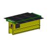
Solar street furniture dedicated to the collection of recyclable packaging
Pierre-Olivier
Abor
3 Building blocks
Huge storage capacity for the Sunbox
Giant LED screen to communicate and boost profitability
autonomous operation thanks to solar panels
Caribbean
Oceania
Solar street furniture dedicated to the collection of recyclable packaging
Pierre-Olivier
Abor
3 Building blocks
Huge storage capacity for the Sunbox
Giant LED screen to communicate and boost profitability
autonomous operation thanks to solar panels
East Asia
Main Policies for Korea National Parks Carbon Neutrality by 2030
Korea National Park Service
- KNPS
East Asia
Main Policies for Korea National Parks Carbon Neutrality by 2030
Korea National Park Service
- KNPS
East Asia
Main Policies for Korea National Parks Carbon Neutrality by 2030
Korea National Park Service
- KNPS
West and Central Africa
Using Advance Technology and AI for Reef Restoration: Implications of Active Management to declare a Marine Protected Area in Mauritius
Nadeem
Nazurally
2 Building blocks
Community engagement and partnerships
Interactive technology for conservation
West and Central Africa
Using Advance Technology and AI for Reef Restoration: Implications of Active Management to declare a Marine Protected Area in Mauritius
Nadeem
Nazurally
2 Building blocks
Community engagement and partnerships
Interactive technology for conservation
West and Central Africa
Using Advance Technology and AI for Reef Restoration: Implications of Active Management to declare a Marine Protected Area in Mauritius
Nadeem
Nazurally
2 Building blocks
Community engagement and partnerships
Interactive technology for conservation
West and Central Africa
Using Advance Technology and AI for Reef Restoration: Implications of Active Management to declare a Marine Protected Area in Mauritius
Nadeem
Nazurally
2 Building blocks
Community engagement and partnerships
Interactive technology for conservation
Pagination
Previous page
‹‹
Page 5
Next page
››
Subscribe to Global