Green Atlas of Urban Ecosystem Services
Full Solution
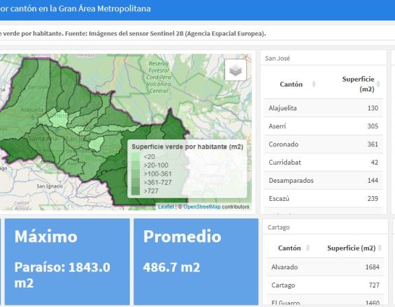
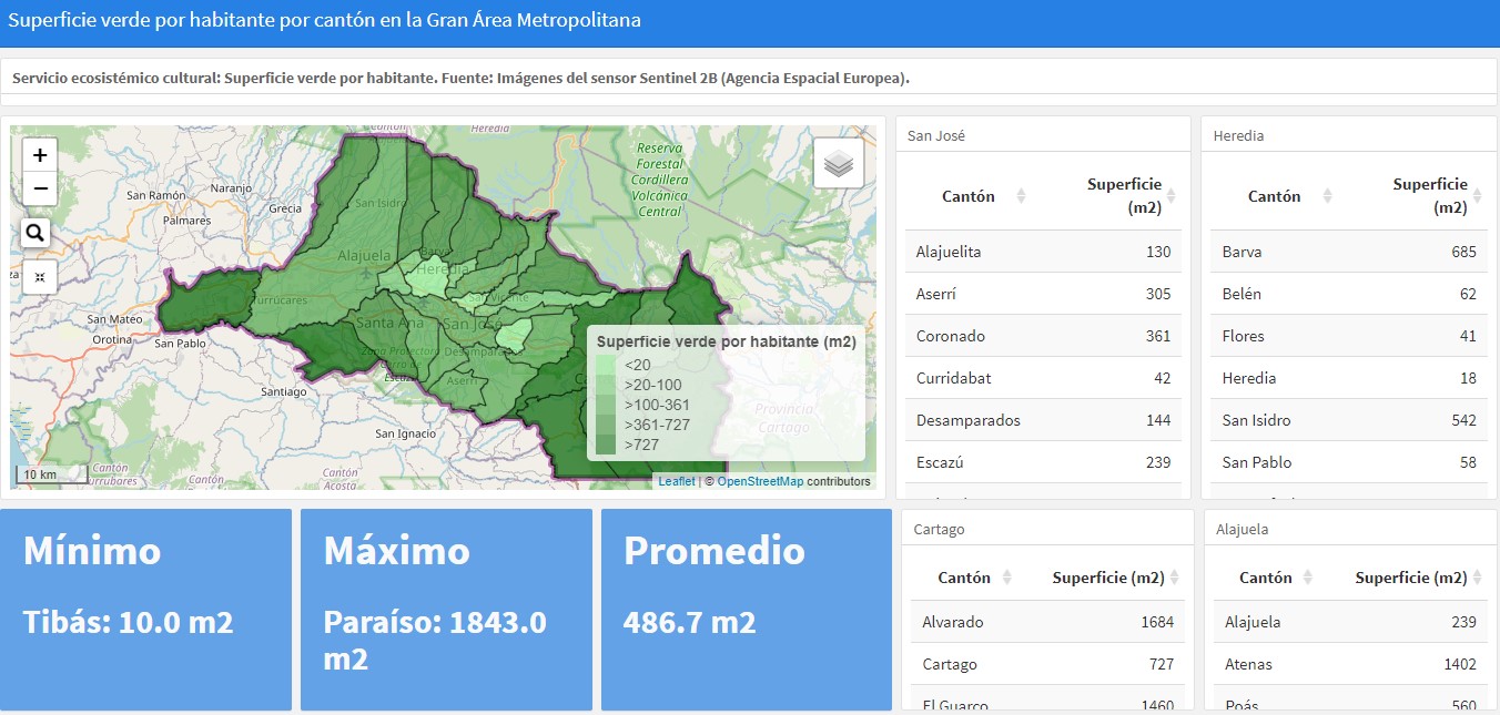
Map of green area per inhabitant
Atlas Verde
The Green Atlas of Ecosystem Services of the Greater Metropolitan Area (GAM) of Costa Rica is an innovative tool that provides unified scientific and geospatial information on urban ecosystem services (UES). It provides users with the necessary data to make informed decisions and generate arguments supported by territorial information for the analysis and construction of strategies, policies and action plans. In this way, its use promotes territorial planning and management that values the well-being of ecosystems and the benefits they bring to human settlements.
Last update: 30 Sep 2025
2833 Views

Context
Challenges addressed
- Disarticulation of geospatial information for territorial planning and management through cantonal boundaries.
- Lack of updated scientific information on the physical-environmental state of urban areas.
- Lack of a functional, open source urban planning tool that is part of the public domain and used for decision making.
- Lack of knowledge of the general public, lack of comprehensible information on the physical-environmental state of the territory and on the relationship between the natural resources of a territory and the benefits they bring to its inhabitants.
- Lack of science-based strategic guidelines for the legal, institutional, financial and technical framework to guide decision-makers.
Location
Greater Metropolitan Area, Costa Rica
San José, Province of San José, Costa Rica
Alajuela, Province of Alajuela, Costa Rica
Cartago, Costa Rica
Heredia, Costa Rica
Central America
Process
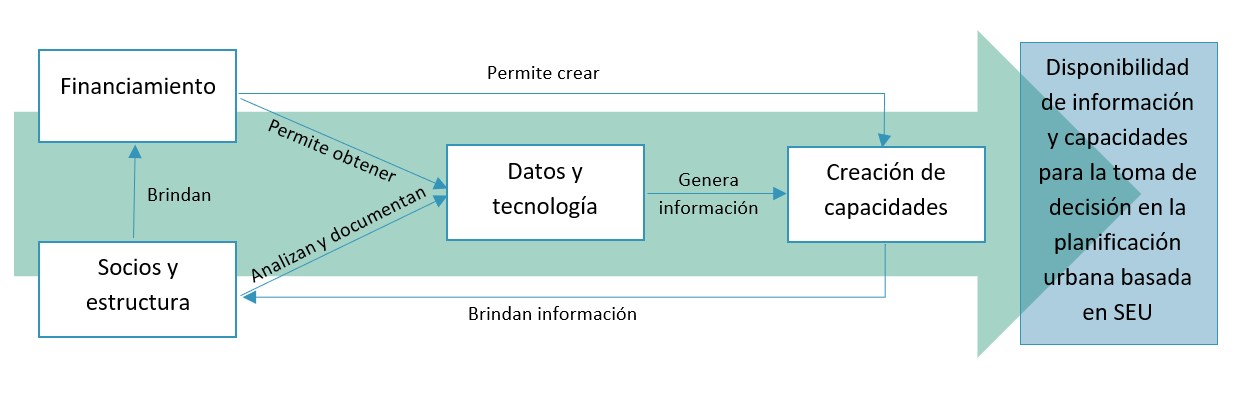
Summary of the process
- It starts with the proposal of the partners and the structure that allow the execution of the solution through the legality of the actions of the actors.
- From this, the partners and the structure are responsible for providing and managing the financing, documentation, satellite images, among others, for the construction of the data and technology.
- In turn, this provides the required information on ecosystem services, which will be used for capacity building and strengthening of urban planning processes by the partners.
Building Blocks
Partners and Structure
Strategically link the actors involved in the planning and development of the tool, through contracting, work sessions and agreements that enable them legally and technically for financing, web hosting, implementation and maintenance, in order to guarantee the sustainability of the Atlas over time, establishing clear leadership in its execution and the support services required.
Enabling factors
- Strategic communication among all parties involved and a clear leadership role.
- Be clear about the role of each actor in the different phases of the implementation of the solution.
- Be clear about the role of governmental institutions, as they are of great importance for the development and validation of the information presented in the tool.
Lesson learned
- Take into account the progress made by other actors and new trends, even if they are not directly part of the project. For urban planning and ecological restoration, it is useful to think beyond political-administrative boundaries.
- It is of utmost importance that each actor has a clear role in the project and in each of its stages (development, implementation and maintenance) and that there are agreements for follow-up.
- It is favorable to have an enabling legal framework defined, which facilitates and promotes the actions of the actors, especially governmental, so that they have the duty to generate and use such tools.
Financing
To have the necessary financial resources available to obtain the data and human resources required for each of the phases of the project by identifying a reliable and continuous source of funding.
Sources of funding may include: Non-governmental organizations and academia, international financing funds, non-profit foundations, national institutional budgets, among others.
Enabling factors
- To have clarity on the necessary budget (project costing), how it will be used and how it will be managed.
- The project was financed by the German Development Cooperation, which provided reliability and stability to the process.
Lesson learned
- Funding is key to the development of such a solution, as it requires expensive geospatial imagery and specialized personnel for information analysis.
- The availability of temporary funding (e.g., through international cooperation) may be the push for the construction of this tool, but it does not ensure its sustainability (maintenance, updating and usefulness in the long term).
Data and Technology


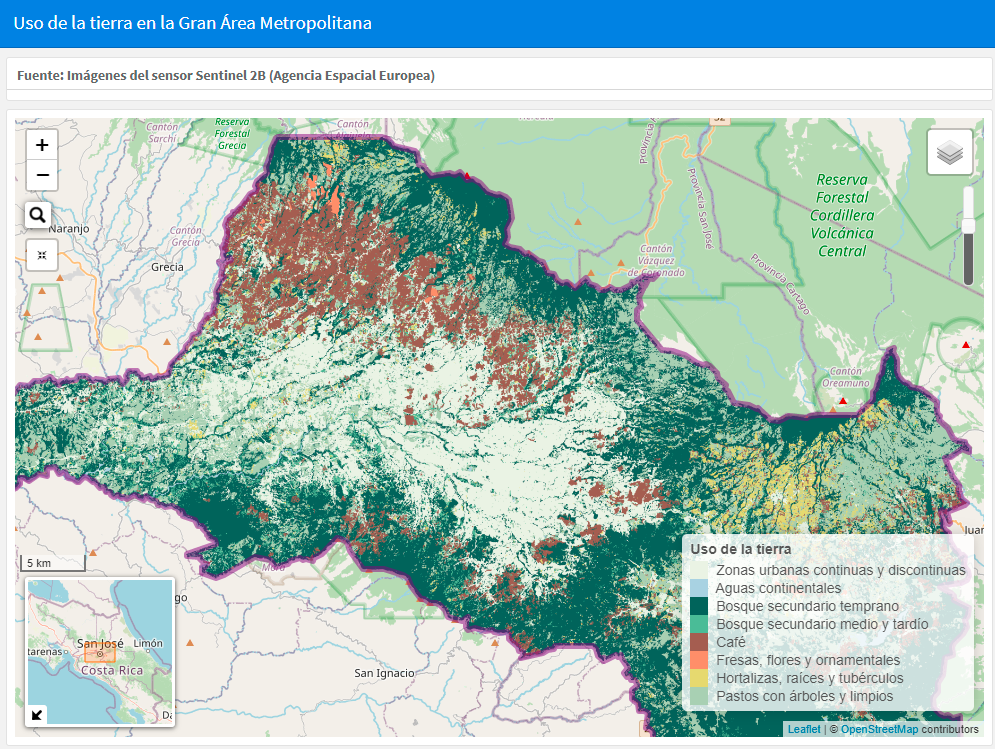
Generate, through the processing of current satellite images in a geographic information system, the necessary geospatial information on biodiversity, built space, surface temperatures, green and blue infrastructure, among others, in order to have the "raw material" for the development of the Atlas. For this purpose, Landsat 8 and Sentinel 2B sensor images were used, which were processed and analyzed by personnel with knowledge in database management and remote sensing, as well as understanding of the social-spatial relationship.
Enabling factors
- CATIE had previous experience in similar projects with some municipalities of the Greater Metropolitan Area of Costa Rica, so there was already a starting point.
- Geospatial information was available in sufficient quantity and quality; data collection was not an obstacle.
- Multidisciplinary work team with adequate technical capabilities.
- Interest and a clear need on the part of the relevant authorities for the information to be generated.
- Clear focus on what information is needed to build the tool.
Lesson learned
- Once the information has been generated, it is necessary to review it in order to analyze which of all the sources of information most accurately represents the physical-environmental state of each site.
- The information needs to be strategically processed and communicated to specific target groups so that it can be used in decision making.
Capacity building and strengthening
Create and strengthen the capacities of the intended users of the Atlas, through workshops and training, in order to maximize the results obtained from the visualization and interpretation of the information provided by the Atlas.
Enabling factors
- Explicit interest and need on the part of the target audience to use the tool and learn about its possible uses for decision-making.
- To have different spaces for training and discussion on the use of the tool.
- It is favorable to have an enabling legal framework that establishes the duty of the stakeholders to use the tool. If it remains a voluntary aspect, it may not be used to its full potential.
Lesson learned
- Focus training processes around the needs of the target audience and exemplify through practical exercises.
- It may be necessary to sensitize and train technicians and decision-makers at different levels, for which the training program should contain conceptual elements for each stakeholder group, based on their role, responsibility and specific tasks.
Impacts
- Identifies priority points for budget investment in ecosystem restoration and public infrastructure.
- Identifies critical and vulnerable points of ecosystems in the territory, allowing the establishment of actions for their protection and/or restoration.
- Identifies points of risk to the health of the population due to exposure to heat islands.
- Quantifies the SEU present in the territory and presents a baseline of data for the Costa Rica metropolitan region of the country, unifying information previously sectorized or distributed in databases of different actors.
- It allows visualizing the benefits provided by natural, semi-natural and modified ecosystems (SEU) within the urban space.
- It allows planning territorial planning around the benefits that society acquires from the presence and use of the SEU.
- Provides information that allows the establishment of strategies and decision-making based on scientific data and analyses that consider the SEU as a transversal axis of urban planning.
Beneficiaries
- Local governments and other governmental entities
- Civil society
- Scientific community
- Urban and peri-urban ecosystems
Sustainable Development Goals
SDG 3 – Good health and well-being
SDG 10 – Reduced inequalities
SDG 11 – Sustainable cities and communities
SDG 13 – Climate action
SDG 15 – Life on land
Story
The canton of La Union in the province of Cartago, Costa Rica, has a territorial extension of 44.83 km2, 97% of the population is urban and has a population density of 2,217 inhabitants/km2. Due to the large amount of gray infrastructure, the local government recognized the impacts that heat islands can have on the well-being of the population. From this, the need arose to identify the heat islands present in the canton and to be able to establish actions based on scientific evidence. In addition, this made it possible to identify priority sites for reforestation efforts and to justify the actions taken for the implementation of nature-based solutions (NBS).
In response, the local government turned to CATIE in search of an instrument to locate and quantify heat islands in the territory, laying the groundwork for what would later, with support from MINAE-SINAC, the German Development Cooperation (GIZ) and the Helmholtz Institute for Environmental Studies (UFZ), become the Green Atlas for the entire Greater Metropolitan Area of the country.
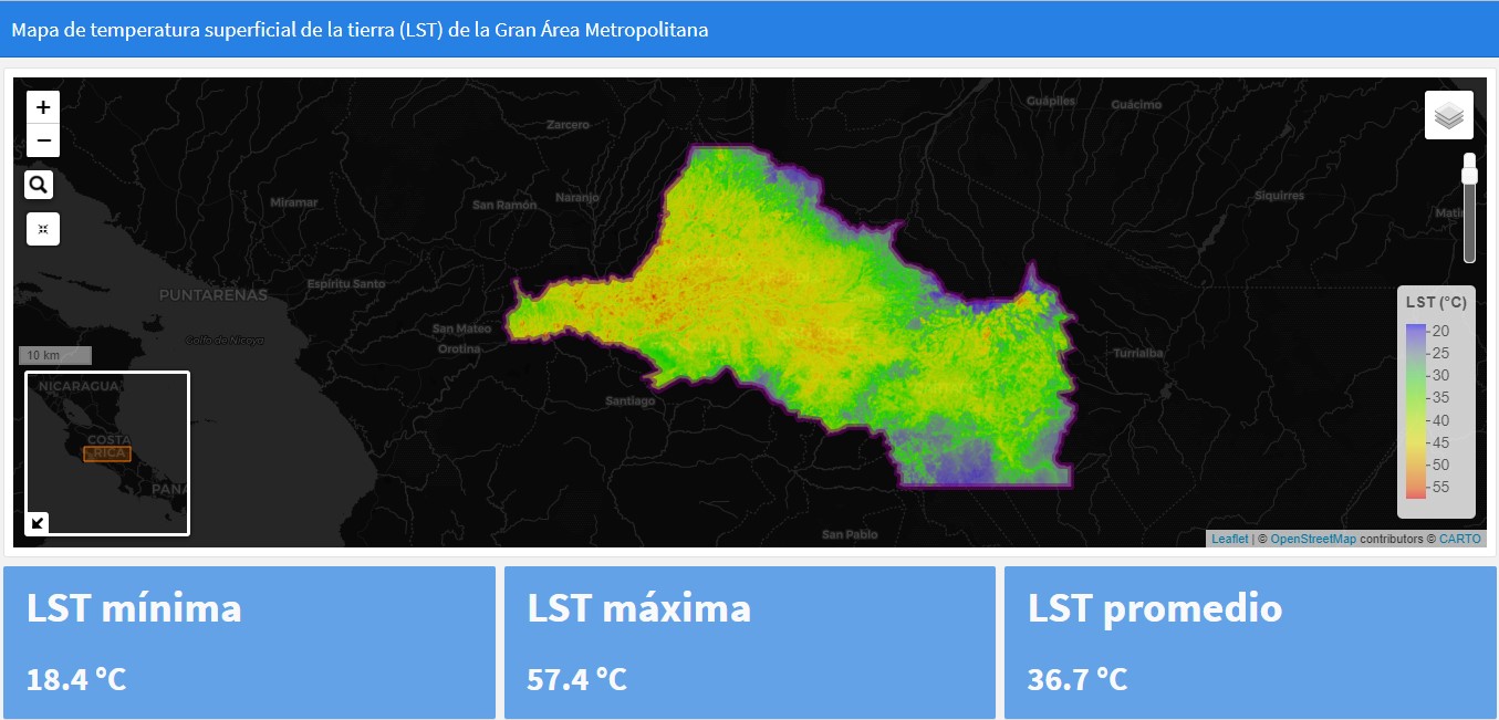
With this first exercise, the municipality identified the presence of several heat islands where the ambient temperature could reach up to 48.7 °C (see map of ground surface temperature). In addition, it was possible to correlate geo-spatially, that these sites coincide with the predominance of gray infrastructure and that in the sites with a more comfortable temperature there is the presence of green areas that regulate the surface temperature. This evidence justified the selection of sites for intervention and implementation of green infrastructure measures (GIS) in order to take advantage of these ES (Ecosystem Services) and make efficient and effective use of the available budget.
As a result, the local government introduced sidewalk gardens, planting trees and native plants, prioritizing areas near schools and health centers. Following this successful project, the municipality will be integrating the use of BNS into its urban planning by allocating budget in its 2022 annual operating plan. Results are expected to be seen in the reduction of heat islands in the medium and long term; in the short term, there has been a positive response from the nearby community and a beautification of the city.
Connect with contributors
Other contributors
Ricardo Laurent
Municipality of La Unión
Christian Brenes
CATIE
Rebeca Brenes
CATIE

