Long-term Commitments and Partnerships

The long-term plan of OMY is embodied not merely by one private developer but jointly initiated by a group of public-private stakeholders across the local business districts. Indeed, the Council for Area Development and Management of OMY, being comprised of 68 landowners, 12 observers, and 8 special members in 2016, established the Advisory Committee on OMY Area Development in 1996 together with the Tokyo Metropolitan Government, Chiyoda Ward, and East Japan Railway Company. As the first area management initiative in the country, the Committee regularly updates the guidelines for redevelopment activities since 1998. These guidelines set out 8 development goals, key functions of zones, axes, and hubs, district design standards, and local operation rules for coordinating cityscape, networking public open spaces, and transferring FARs. Furthermore, the committee has introduced a variety of area management and place-making initiatives such as free loop bus service, car-free public spaces, establishment of a district-level association, and various city events.

  • Council for Area Development and Management of OMY (comprised of 68 landowners, 12 observers, and 8 special members)
  • Coordination across the local govenrment, the ward government, and the railway company
  • Legalization of the Area Management Initiative

Large-scale redevelopment projects generally require the complex and painstaking coordination of property rights among various stakeholders. The long-term commitment of major developers and the establishment of horizontal partnerships are essential for intergenerational redevelopments and sustainable area management. Many details of urban design, operation, and place-making efforts must be initiated and guided in local specific ways.

Market Incentives for Social Capital Improvements

Accompanied by private redevelopment projects, the national government decided to restore the old redbrick building of Tokyo Station, initially built in 1912 and damaged by firebombing during World War II. While the symbolic building restoration was expected to have broader social and cultural benefits for the neighboring business districts, its project cost was estimated around JPY50 billion. In order to meet both social and commercial objectives, the site of Tokyo Station was extensively designated as a zone for the special FAR exemption and allowed to transfer the unused FARs from the historic redbrick building to the neighboring lots for new commercial tower developments. The station building restoration, partially financed by the FAR transfer revenues, was successfully completed in 2013 by a railway company, which also developed two 205-meter tall skyscrapers among the towers with extra FARs, and reinvested the increase in land value of the densified grade-A office buildings to cover the railway finance. To improve the district further, the current provision of a multimodal transportation square for regular bus and taxi services plans is to be completed by East Japan Railway Company in partnership with the Tokyo Metropolitan Government in 2017.

  • Legislative and institutional requirements met to apply bonus FAR schemes
  • Finance mechanism to cover a vast amount of capital improvement cost through land value capture

  • Sound approach for land and property value assessment

Private redevelopment projects could meet both commercial and social objectives if market incentives are properly given for public capital improvements. In particular, the exemption and transfers of extra FARs should be designed not merely to increase short-term business profitability but rather to raise public funds for life cycle asset management.  

Going the extra mile

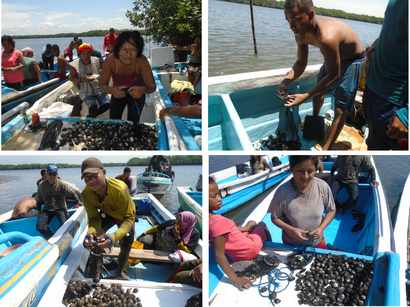
Once the creative process has started, ideas have turned into plans, and there are high expectations about what can be achieved, the Association faced the dilemma of fast profiting, by catching all product available (altought at lower price per unit), or long term profiting, establishing a catch-limit in order to ensure the availability of high quality product (better valued, and allowing black shell population to meet its life cycle).
Since the second alternative seemed more rational for members, the had to design the tool to manage the catch limit. The solution was to set the catch-size 2 millimeters above the legal limit to catch, and to adopt some several regulations into their rules of procedure. That is, to pass from some crazy ideas to a disciplinated implementation with strong sanctions ( monetary and suspension of the fishing rights of the members) aprooved by the total of the members.

Strong comunity and associative principles allowed to adopt mature decisions, even those perceived as too restrictive.


The certainty that in order to achieve a better future, changes in their way of living must be done.

To be confident into their propositions, and to not be afraid of the uncertainty of their decissions.

Disciplined implementation is a key factor.

Rotate the responsibility of administrative management allows most of them to understand the importance of control role and to respect eachother, reducing unrest potential.

Creative participation

Despite self-clousures are well known measures in order to preserve a biological resource, it has never been applied by the Association or the black shell resource in the area. Creative sessions have allowed members to propose ideas (self-clousures) to the plenary, and the creative participation on analyzing and discussing its benefits and consequences have helped to develop complementary measures (like zonification and a fattening area), obtaining a more robust and fruitful plan.

Trust environment for working sessions allow to talk in an open and confident way, and allow creativity outcrops.

Do not throw away ideas. Allow the discussion of all of them, enabling open participation.

Cooperative networking

Association Las Huacas has developed a Cooperative networking with different allies from private and public sectors. Partnership agreement with GEOGES C.Ltda. (environmental consultancy agency), wich has been interested into cooperate with ancient populations in order to preserve the culture and traditions, as well as to recover the optimal conditions for mangrove development and conservation.
The agreement brings to the association the technical capabilities of the Agency, in order to get the assistance to design- implement- and follow up of the management plan. The agreement has also served as a framework for cooperation at different levels – community, asociation – in order to enforce the organizational aspects of both institutions, as well as to propose and to develop alternative initiatives of production or self-employment, and the critical analysis of thrird parties cooperation initiatives.

To find the right partner, relative objectives and vision (apply to bothsides).

Total commitment to cooperation, with full involvement of the members into the planned activities.

Long-term follow-up, in order to create and to register data that will allow future decission making.


Active participation in identifiying issues and planning process will allow better understanding of the issues and more realistic paths to deal with it.

Try and failure process is also necessary in order to understand different dynamics working at the time, and to develop successful next steps.

Importance of conservation

Scientists, who have been monitoring the area before it was closed, estimate a 500% increase in biomass within the area since the closure. The area, previously covered with sea urchins, is now a thriving biodiversity hotspot with the balance restored. The elders report new species in the MPA that have not been seen in living memory. The coral, previously destroyed by human feet, has recovered quickly and the lagoon area is now known as one of the best snorkelling destinations on the Kenyan coast. Local and international students come and learn in our living marine classroom. Turtles feed on the seagrass beds undisturbed, and the number of nests has increased significantly. The area has returned from being a marine desert to a marine paradise and a critical model globally that shows how a poor community can help conserve nature and benefit from it too. Bigger and better catches outside the MPA has ensured support for the permanent closure.


The MPA could not have gone a head without the belief and forsight of the fisherfolk in the area and the acceptance to beleive that positive change was possible even in difficult circumstances. Local knowledge from the elders ensured a suitable site for the closure was chosen. Scientific research also supported the choice as having the most potential for long term improvement. Regular updates on improvements within the MPA has helped sure up the belief that it is successful as a breeding area.

That nature is resilient and can recover amazingly quickly if left alone to do so. Identifying needs and fostering willingness to embrace change can improve livelihoods. The importance of undertaking an environmental impact assessment on the area, underpinned by research and local knowledge, before the project started has been a critical factor towards the success of the MPA. Constant awareness and updates of the improvement in the MPA need to be communicated back to the community. Analysing the information can be used to put into perspective in the socio-economic impact. The importance of communication of our progress back to the community has been something we have had to improve. When the community understands and sees the benefits from change they are, understandably, more willing to accept it.

Technical support from different sectors and infrastructure support from LGU

To empower the people's organisations, government, NGOs and private entities shard their expertise and provided them technical support. The LGU, government agencies and NGOs trained them to be able to manage their own organisations, practice community based management, and the technical skills on how to manage tourism activities.  SIKAT, an NGO with significant years of experience in community-based coastal resource management program implementation also provided them with training on basic ecology and training and technical support in Marine Protected Area Management.

  • Partnership and good working relationship of LGU with other government agencies, non-government organizations and private entities
  • The ability of the LGU to network also helped them gain support from other government agencies, who provided them with trainings on the different aspects of tourism, and helped build their capacities to manage their organizations.
  • An NGO provided them training on ecology and Marine Protected Area Management to capacitate them in their environment management role
  • Participatory process in the identification of trainings.
  • Capacity building on organizational skills and on environment conservation is as important as the technical trainings on tourism management.
Marine protected area (MPA)

Community recognition that action was needed to improve dwindling fish stocks was followed by the identification of various stakeholders to help us achieve our goals. Communication, outreach and awareness building programmes were set up and a visit to a similar project in Tanzania went ahead in 2004, and encouraged the community to use local marine resources sustainably.


A democratic decision to close an agreed lagoon area was agreed. Legal and policy frameworks were put in place, and the first LMMA in Kenya was approved in 2006 under the National Environmental Management Authority. Following this, a collaborative governance model has emerged under Beach Management Units (BMU's), where fishers and government work together towards sustainable fishing and improved livelihoods. In setting up the MPA, we went through various phases; conceptualisation; inception; implementation; monitoring; management and ongoing adaptive management.


The realisation by the community that there was a significant crisis looming and a determination to act for the sake of future generations was a crucial factor in the implementation process. Trust and belief in a positive outcome was paramount. Initial funding for alternative enterprises and support from key partners was necessary for technical and advisory capacities. An area was chosen that had good recovery potential with help from a scientist that had previously been monitoring that part of the coast coupled with local knowledge.

From the outset a clear strategy and management plan devised with maximum participation from community members is critical. Listening to the elders within the community creates an essential link between past and present. Targets and goals need to be achievable and clear timelines need to be set and adhered to keep the support of the community. The entire community needs to benefit from the project, and livelihoods need to improve tangibly in order to maintain support and create a sense of ownership that gives the project longevity. A community welfare aspect should be part of the strategy. Awareness, education and sharing of information need to be maintained, and a willingness to an adaptive management approach is vital. Learning from mistakes, sharing knowledge and creating close alliances with other similar organisations helps the project progress quickly. Creating collaborative partnerships and following clear procedures and legislative guidelines strengthen the structure of any entity. Good governance from the outset with a clear constitution that is followed at all times. 

Awareness raising campaigns at local level

Awareness raising campaigns were conducted in each of the 9 cantons. They covered the following elements:


  1. field to discuss about FLR and the planning of potential activities
  2. local meetings with 77 villages, to share findings from field visits
  3. radio programs in local languages
  4. exchange sessions with the prefectural director for environment,
  5. design & development of signboards for each village


After the participative mapping and inventory findings were shared with the communities by the installation of synoptic tables in the villages themselves, visible and accessible for everyone. This triggered community internal discussions and allowed to identify one or two low-cost restoration options per village to be implemented by the communities themselves under the technical supervision by forest service staff. The continuous information provision via various awareness raising formats and participatory meetings to identify FLR priority options in each of the cantons, led to a high momentum and legitimacy in the communities to engage in restoration.

  • Openness by land users to participate since most are facing severe challenges (e.g. lack of fuel wood, soil degradation) and see a direct benefit in restoration
  • Preparatory visits to restoration hotspots and workshops including agreements with prefectural authorities & traditional chiefs
  • Local NGOs as very trustful partners
  • Successful activities of GIZ in the Mono Delta Transboundary Biosphere Reserve provided convincing arguments to support restoration
  • It is essential but also challenging to define the appropriate group size to reach the maximum of the members of the communities (village or cantonal level)
  • The content of communication products and messages needs to be adapted to the circumstances of each canton
  • The right language for communication is crucial: Early on the decision was made to use the local dialect for a common understanding of all
  • The integration of women in all phases of the process was crucial for its success.
Forest inventory at subnational level

The inventory of natural forests and plantations was based on the participatory mapping. It covered the following steps:


1. Training of forest inventory teams

2. Definition of forest types and layers (stratification): analysis and interpretation of RapidEye 2013-2014 satellite images (resolution of 5 m x 5 m)

3. Implementation of pre-inventory: Assessment of results from national forest inventory, preparation of field work, determination of variation coefficient and statistical method, measurement of 20 circular plots. Inventory of main forest stand with a 20 m radius for samples ≥ 10 cm in diameter and ≥ 1.30 m height; inventory of forest undergrowth in circular plots with 4 m radius on trees and shrubs samples with a diameter between 5 and 10 cm open and a height ≥ 1.30 m

4. Implementation of inventory: preparation of field work, measurement of 173 circular plots with same sample plot features as during pre-inventory and with the support of local cartographers.  

5. Data processing at regional management level with support from the inventory database management unit

6. Zonation and identification of forest landscape restoration options
 

  • Experience of technical staff of MERF in carrying out the first national forest inventory of Togo
  • Existence of forest and cartographic data management units within MERF
  • Using results of the first national forest inventory at the regional level
  • Availability of RapidEye satellite images (2013-2014)
  • Evaluation of restoration potential of forest landscapes study in Togo (2016)
  • Guidance and knowledge of local cartographers about the local resources during the forest inventory
  • A thorough identification and mapping of actors in the beginning of the inventory was crucial to form a solid coordination structure
  • It was crucial to keep the interest and support of local communities in the inventory process, based on regular communication and awareness raising
  • The local forestry administration implemented the inventory at community level in a very remarkable way; the participatory process put foresters in a new role of highly appreciated community advisers and companions for forest management. The administration - once perceived as a repressive force and authoritarian manager of resources – was accepted by the community as a partner
  • The inventory, including the identification of 70 tree species in total (incl. 24 families & 65 genera) in the four zones, increased the awareness about existing biodiversity and their potential in the context of forest landscape restoration and climate change adaptation