Slovenian Olympic Forest
South America
South Asia
West and South Europe
Oceania
Fabrizio
D'Angelo
Building block 1 – Using an existing initiative (the Olympic Forest) as a blueprint for National Olympic Commit-tees to initiate their own nature restoration projects.
Building block 2 – Establishing principles for admitting National Olympic Committees’ projects to the Olympic Forest network
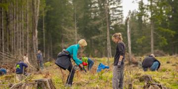
Building block 3 – Embracing local expertise, governance, and ownership of projects
Building block 4 – Cooperation between NOCs and local nature conservation organisations as a prerequisite for success
Political will and a mandate for developing a multi-stakeholder initiative to strengthen Inclusive Sustainable Blue Economy in the WIO region

The Western Indian Ocean (WIO) region is recognized globally as a biodiversity hotspot with high ecological and socio-economic value. However, with increased global demand for natural resources, pollution, climate change, and a diversity of unsustainable economic activities, the region’s fragile coastal and marine ecosystems are under threat. In response to this, efforts and innovative solutions are urgently required as a business-as-usual scenario will likely result in the depletion of coastal and marine resources and associated socio-economic benefits. Starting in 2020, to bolster collective leadership between state, private sector, and civil society actors, GIZ’s Western Indian Ocean Governance Initiative (WIOGI) and partners supported discussions to develop a regional multi-stakeholder initiative for an Inclusive Sustainable Blue Economy in the Western Indian Ocean region. This proposal was presented and endorsed during the tenth Nairobi Convention Conference of Parties (Decision CP.10/12) in November 2021.

  • Having an official mandate is an essential success factor for such a participatory, multi-stakeholder, and multi-sectoral process. It helps create ownership for the process and continuous collaboration within the Our Blue Future alliance.


  • It is important to have a clear role for governments in a multi-stakeholder initiative. Without an appropriate role for government actors, their willingness to join the initiative becomes challenging. 

  • Multi-stakeholder and collective leadership approaches are essential to engaging in high-quality dialogue among key actors, an essential basis for forming action-oriented partnerships across the region.

Judy Kosgei/WWF
Political will and a mandate for developing a multi-stakeholder initiative to strengthen Inclusive Sustainable Blue Economy in the WIO region
Multi-stakeholder approach
Involving the private sector
Moving towards implementation and impact on the ground
Judy Kosgei/WWF
Political will and a mandate for developing a multi-stakeholder initiative to strengthen Inclusive Sustainable Blue Economy in the WIO region
Multi-stakeholder approach
Involving the private sector
Moving towards implementation and impact on the ground
Judy Kosgei/WWF
Political will and a mandate for developing a multi-stakeholder initiative to strengthen Inclusive Sustainable Blue Economy in the WIO region
Multi-stakeholder approach
Involving the private sector
Moving towards implementation and impact on the ground
Drone Data

Drones play a pivotal role in the 3LD-Monitoring system, complementing other data collection methods.Drones are essential tools in partner countries to fortify technical skills among local staff. These skills encompass flight planning, navigation and image evaluation. The drone monitoring aims to empower project staff to capture data tailored for photogrammetric analyses, from which crucial geoinformation emerges.

The drone mapping methodology encompasses five stages, with the first two focusing on drone operations:


  1. Mapping mission preparation (desktop work)
  2. Mapping mission execution (fieldwork)
  3. Development of Digital Surface Model (DSM) & Orthomosaic generation (desktop work)
  4. Data analysis and refinement (desktop work)
  5. Integration into the prevailing data system (desktop work)


Drone data aids in evaluating indicators linked to carbon/biomass, such as mortality rates and forest types. Notably, with the application of allometric equations and proper characterization of the land type, above-ground biomass estimations of trees can be determined.

Drones with pre-set flight planning capability ensure seamless orthophoto creation from individual images. This enables individual snapshots to seamlessly merge into an orthophoto (aerial photograph corrected for distortions, allowing accurate measurements). It's also vital to consider the availability of these drones in the local markets of partner countries. Leveraging local knowledge by involving local academia is paramount in this process. They can provide essential allometric equations, grounded in tree height, that facilitate precise biomass calculations.

Drones generate high resolution images, allowing a detailed overview of land cover changes, tree survival and erosion rates, among others. Combined with field data, drone-based monitoring is strengthened, guaranteeing a sound monitoring.


The heterogeneity of trees and vegetation density often hinders a sound extraction of common key points between the images, which is necessary to estimate the heights and other indicators. In this regard, increasing the overlap between images to a minimum of 85 % frontal and side overlap can improve the extraction of key points. Also, increasing the flight height of the drone reduces perspective distortion, which facilitates the detection of visual similarities between overlapping images. However, too much overlapping, i.e., high overlapping percentages result in higher amount of data, making data processing more time intensive.


Another aspect already mentioned is the availability of suitable drones in the partner countries. Importing drones to the respective countries is difficult, and bureaucratic barriers persist.

Satellite Data

Satellite data forms the bedrock of the 3LD-Monitoring system, harnessing the capabilities of open-source imagery from the Copernicus Sentinel-2 and LANDSAT satellites. An algorithm, meticulously developed by Remote Sensing Solutions (RSS) GmbH, revolutionizes this process. Users can seamlessly submit the shapefile of their area of interest, prompting the algorithm to automatically fetch and analyze relevant data. A spectrum of robust analyses are conducted including the 5-year vegetation trend using NDVI for assessing vegetation gains or losses, 5-year vegetation moisture analysis through NDWI, and a nuanced 5-year rainfall trend evaluation. Additionally, the algorithm facilitates the visualization of vegetation changes since the inception of the project, bolstering the monitoring framework with dynamic insights. Satellite data, a vital component of the 3LDM-Monitoring system, leverages open-source imagery from the Copernicus Sentinel-2 mission and LANDSAT satellites. For predefined areas, this data is automatically fetched and analyzed for specific parameters. Key analyses include a 5-year vegetation trend using NDVI as a proxy for vegetation gains or losses, a 5-year vegetation moisture trend through NDWI, and a 5-year rainfall trend. In addition vegetation changes from project start can be visualized.

Effective use of this building block hinges on users drawing and saving areas in GIS platforms like QGIS. Additionally, enhancing the shapefile with project specifics, such as start dates and FLR type, optimizes analysis. Proper training in these skills ensures accurate data input and tailored monitoring, making capacity building in these areas essential if not present.

While satellite data, especially open-source, offers broad insights, its capability for species identification is highly restricted, if not unattainable. This limitation emphasizes the indispensable role of field work in discerning species composition and characteristics. Additionally, understanding the innate constraints of satellite imagery, especially with young tree plantations, reinforces the need for integrating field and drone data to gain a comprehensive view of forest terrains.

Efficient Monitoring, Reporting and Verification (MRV) system

Compared to similar carbon projects in agriculture, the Western Kenya Soil Carbon Project piloted an efficient Monitoring, Reporting and Verification (MRV) system. By using a modelling approach instead of pure activity monitoring, monitoring costs of the scheme could be decreased significantly. Also, the pilot uses digital monitoring tools (app), which makes the MRV more efficient. The digitalized MRV system provides the potential to integrate commodity market platform access for smallholder farmers. 

Sufficient financial resources to ensure the availability of digtial tools are important. Moreover people need to be available in the field to introduce farmers to the digital tools like apps and help with problems and questions. A coordination entity to supervise this but also the whole MRV process and its quality is thus a key component.

Increasing the efficiency of carbon schemes requires reduction of transaction costs, for example by applying satellite-based SOC monitoring or digital extension service support systems. To improve partner countries' national climate MRV system efficiency, it is recommended to link carbon projects MRV to national carbon registries. 

Baseline

The baseline refers to the projection of greenhouse gas (GHG) emissions that would occur in a specific project area if no interventions or changes to current practices are implemented. This serves as a point of comparison to assess the effectiveness of the carbon project in reducing emissions.

The baseline is essential for calculating the actual carbon reductions attributable to the Capercaillie project and to measure the project’s impact on mitigating climate change.

The baseline sets the benchmark for assessing the carbon reduction achievements of the project and is therefore highly relevant for the issuance of CO2 certificates. Especially demanding is the forecast of the developement in a given area over long periods of time, which plays a crucial role on the amount of CO2 certificates issued. The long term protection goal in protected and conserved area is therefore a important advantage for the long term sequestration of CO2 equivalents. 

Long-term sequestration

Long-term sequestration refers to the practice of capturing, securing, and storing  greenhouse gas (GHG) or other forms of carbon from the atmosphere for an extended period of time, ideally indefinitely.

The goal of long-term sequestration is to mitigate the effects of climate change by reducing the levels of CO2 and other greenhouse gases in the atmosphere.

It is important that the used methods are sustainable and secure to ensure that the carbon does not re-enter the atmosphere. In this pilot, we reached that goal through using the wood for construction purposes in the area near the forest reserve. 

Long-term sequestration is essential for stabilizing global carbon levels and is considered a crucial component in efforts to combat climate change, but to identify and secure the long term storage of CO2 in construction sites is a large task and costly exercise.