Skip to main content
Main navigation
Explore solutions
Network
Resources
News & Events
Contribute solution
Secondary navigation
About PANORAMA
Partners and Collaborators
Communities
Utilities navigation
Newsletter
Manual
FAQ
English
English
Français
Español
Deutsch
Italiano
中文
العربية
Bahasa Indonesia
한국어
Русский
Português
日本語
Nederlands
Türkçe
User account menu
Log in
Register
Southeast Asia
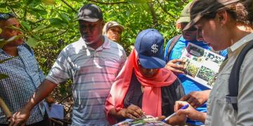
Training on Disease Prevention, Detection, Response and Recovery for Protected Area Managers in Vietnam
Jimmy
Lee
Central America
Footprints4ourFuture: A Crowdfunding Campaign for Sustainable Reforestation and Job Creation in Costa Rica
Gamze
Akarsu
4 Building blocks
Combining a variety of donation options and marketing strategies to promote contributions
Using funds to improve the living conditions of vulnerable populations while promoting tree planting and ongoing maintenance in an integrated way
Multi-stakeholder partnerships for effective campaign design and gender-responsive implementation
Innovative tools for monitoring tree planting and maintenance
West and Central Africa
East and South Africa
Central America
South America
North and Central Asia
Southeast Asia
South Asia
East Asia
International Alliance against Health Risks in Wildlife Trade
Secretariat of
International Alliance against Health Risks in Wildlife Trade
6 Building blocks
Project Map
Funded Projects
Country packages
Members Area
Working Groups
Governmental Consultation Facility
East and South Africa
Roots of Change: Community-Based Ecological Mangrove Restoration in Kenya
Susanna
Tol
3 Building blocks
Capacity building, Knowledge sharing and awareness raising on CBEMR with Stakeholders
Establishment of CBEMR demonstration site for learning and research
Monitoring and evaluation for evidence-based practice and sustainability
East and South Africa
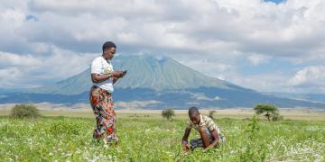
Catalyzing Community Action for Resilient Grasslands
Neovitus
Sianga
Caribbean
Central America
South America
Blue Carbon A-Z: from small projects to policy development
Miguel
Cifuentes-Jara
6 Building blocks
Carbon inventories in mangrove ecosystems
Social and ecological vulnerability assessments
Geospatial and emissions modeling
Ecosystem services valuation
Development of national policy frameworks
Promoting blue carbon networks
East and South Africa
Community participation in PA management provides development benefits
Christophe
Du Castel
3 Building blocks
Revitalizing community engagement in park management
Community action for sustainable artisanal fisheries
Sustainable agriculture in watersheds and vulnerable coasts
Caribbean
Central America
Coastal Communities combat Climate Change
Téa
Garcia-Huidobro
3 Building blocks
Focal management targets
Social indicators
Communication and coordination networks
West and South Europe
Assessment of individual PAs’ contribution to environmental conventions
Volker
Mauerhofer
3 Building blocks
Selection of relevant MEAs and (sub-)national legislation
Identify activities contributing to MEA implementation
Develop, discuss and evaluate PA management recommendations
East and South Africa
The use of interpretation to influence the behavior of snorkelers
Sander
den Haring
4 Building blocks
Identifying salient beliefs of target audience
Interpretive training workshop
Interpretive tools to influence behavior
Post training monitoring of progress and feedback
Pagination
Previous page
‹‹
Page 24
Next page
››
Subscribe to Subnational