
Embedding Integrated Water Resources Management in Rwanda's Sebeya Catchment
Full Solution
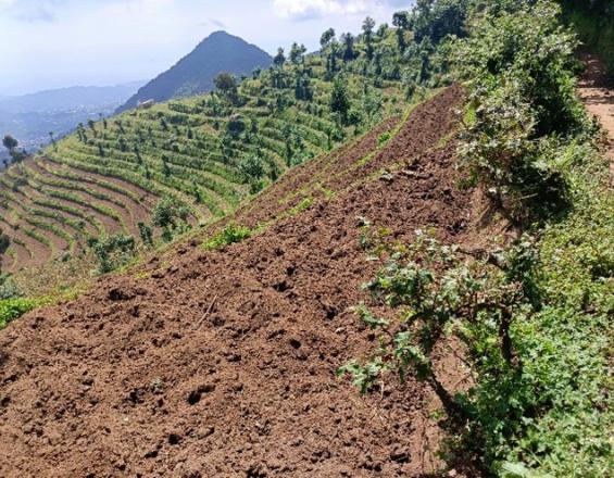
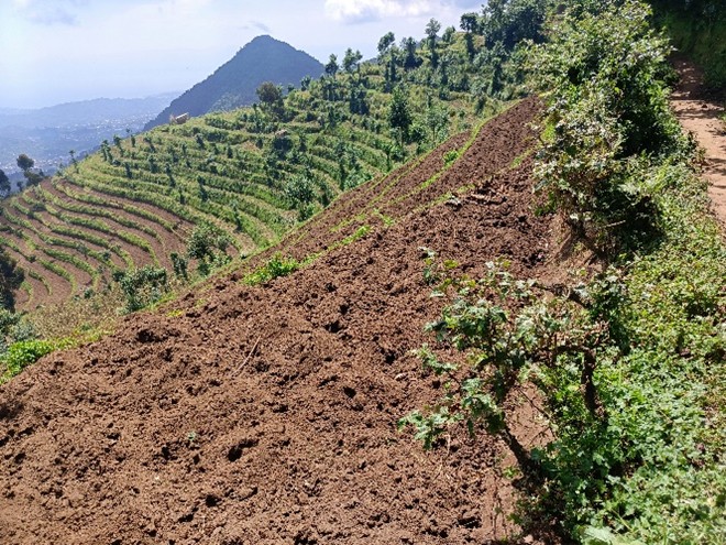
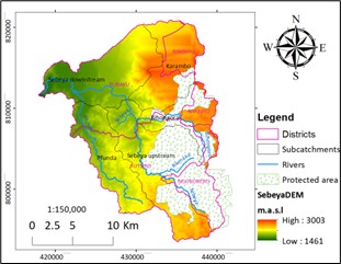
Natural context of the site-Kanama sector
RUTEBUKA Jules
The Sebeya catchment in Western Rwanda, once prone to recurrent flooding, erosion, and landslides, was transformed through the "Embedding Integrated Water Resources Management in Rwanda (EWMR)" project. Led by Rwanda Water Resources Board and partners, the project applied Nature-based Solutions (NbS) to restore 7,700 hectares using terraces, trenches, riverbank protections, and afforestation. The approach combined land rehabilitation with innovative financing, value chains, and inclusive planning. Over 35,000 green jobs were created, alongside improved soil health, aquifer recharge, agricultural productivity, and livelihoods. By integrating community-driven land use planning into district-level governance, the project laid the foundation for long-term resilience and scalability.
Last update: 20 Nov 2025
139 Views
Photo and video gallery
Context
Challenges addressed
The Sebeya catchment faced severe environmental degradation: deforestation, soil erosion, flooding, and landslides due to steep slopes and intense rainfall. Socially, communities lacked access to clean water, sustainable livelihoods, and inclusive planning mechanisms. Economically, agriculture—covering over 74% of land—suffered from low productivity due to poor soil health, leading to poverty and food insecurity. The project tackled these interconnected challenges through integrated restoration, improved water and soil management, community mobilization, and nature-based infrastructure. It also addressed weak institutional coordination by embedding participatory land use planning within formal district governance systems.
Location
Western, Rwanda
East and South Africa
Process
Summary of the process
The project began by engaging communities in VLUAP development to identify local needs and plan interventions. Restoration techniques were selected based on topography, soil conditions, and community inputs. Implementation was coordinated across government agencies and partners, while livelihood support, including livestock, water tanks, kitchen gardens, and improved cookstoves, complemented ecological goals. Financing innovations such as VSLAs and Community Environmental Conservation Funds supported resilience. Soil health and biodiversity monitoring were conducted to evaluate impact, and results fed into adaptive planning. All components were interlinked, with participatory governance anchoring the solution.
Building Blocks
Restoration of Degraded Lands Using Nature-based Solutions
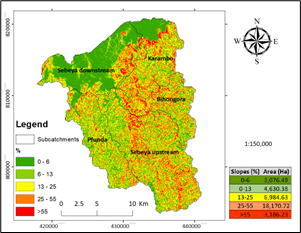
Land degradation in Sebeya was addressed by restoring 7,700 hectares with terraces (both radical and progressive), afforestation, trenching in forests and tea plantations, gully treatment, and riverbank protection. These interventions stabilized soils, reduced runoff, improved infiltration, and minimized landslide and flood risks. Restoration activities were tailored to agro-ecological zones, and linked to productivity improvements. Afforestation and fruit tree planting contributed to erosion control and diversified incomes.
Enabling factors
The success of the restoration activities was enabled by a combination of strong institutional collaboration and a well-financed, multi-stakeholder implementation framework. Funding from the Embassy of the Netherlands provided financial stability and flexibility to scale restoration interventions. Technical and organizational support from RWB, IUCN, SNV, and RWARRI ensured that scientifically informed and community-adapted techniques were applied. Crucially, the involvement of local communities from the outset fostered ownership and facilitated the co-design of interventions. Integration into local government planning processes through District Imihigo secured political commitment and long-term alignment with regional development goals. Lastly, the technical capacity provided by national agriculture and environment institutions allowed for monitoring and adaptive management during implementation.
Lesson learned
Local ownership and community co-design were critical for sustained impact. Use of locally appropriate restoration techniques ensured effectiveness. However, extreme rainfall events continue to challenge the durability of interventions. Future efforts must integrate disaster risk management and climate-resilient infrastructure. Agroecological zoning and adaptive management based on soil and water assessments were key success factors. Challenges included limited capacity for post-project maintenance, underscoring the need for local government commitment and ongoing finance mechanisms.
Community-driven Village Land Use Action Planning (VLUAPs)
VLUAPs were developed in 200 villages through participatory processes involving women, youth, indigenous people, agribusinesses, NGOs, and churches. The plans identified land use priorities and restoration needs and were integrated into district-level annual plans and budgets. This alignment with the District Imihigo performance system ensured local accountability and long-term institutional support.
Enabling factors
The institutional framework of Rwanda’s decentralization policy allowed for effective integration of local land use plans into district performance contracts, providing both legitimacy and enforceability. RWARRI and IUCN played key roles as facilitators of inclusive stakeholder engagement, ensuring that all groups—including marginalized communities—had a voice in planning. Strong local leadership helped sustain momentum and promote transparency throughout the VLUAP process. Technical guidance from agricultural (RAB, MINAGRI) and environmental (RWB, REMA) agencies ensured feasibility of proposed land uses. Continuous dialogue, backed by trust and mutual respect, created a positive environment for collaboration and accountability across government and community levels.
Lesson learned
Participation ensures legitimacy, but requires time, capacity-building, and sustained facilitation. Inclusion of marginalized groups increased equity and strengthened social cohesion. Challenges included managing diverse expectations and aligning technical interventions with community priorities. Embedding VLUAPs in governance frameworks created continuity beyond project timelines.
Impacts
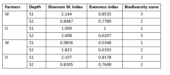
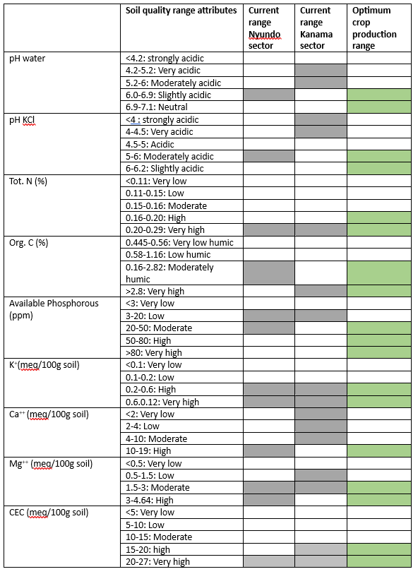
The EWMR project delivered significant environmental, economic, and social benefits. It restored 7,700 hectares, improved soil health, and enhanced biodiversity. Soil organic carbon and nitrogen increased in both Nyundo and Kanama sectors, with reduced acidity and improved C:N ratios. Invertebrate diversity increased, with higher Shannon indices in intervention zones. Over 35,000 green jobs were created through restoration and livelihood support. Distribution of 758 rainwater harvesting tanks improved water security and reduced erosion. 328 livestock units, 3,563 improved cookstoves, and 350,000 fruit trees boosted household resilience and reduced forest pressure. The creation of 331 VSLAs and CECFs provided financial inclusion. Disaster risks decreased through improved water infiltration and reduced runoff, and local governance was strengthened by embedding land use planning in official budgets and monitoring systems.
Beneficiaries
Local farmers, youth, women, indigenous communities, district planners, and supply chain actors
Global Biodiversity Framework (GBF)
GBF Target 2 – Restore 30% of all Degraded Ecosystems
GBF Target 8 – Minimize the Impacts of Climate Change on Biodiversity and Build Resilience
GBF Target 10 – Enhance Biodiversity and Sustainability in Agriculture, Aquaculture, Fisheries, and Forestry
GBF Target 11 – Restore, Maintain and Enhance Nature’s Contributions to People
GBF Target 14 – Integrate Biodiversity in Decision-Making at Every Level
GBF Target 20 – Strengthen Capacity-Building, Technology Transfer, and Scientific and Technical Cooperation for Biodiversity
GBF Target 21 – Ensure That Knowledge Is Available and Accessible To Guide Biodiversity Action
GBF Target 22 – Ensure Participation in Decision-Making and Access to Justice and Information Related to Biodiversity for all
Sustainable Development Goals
SDG 1 – No poverty
SDG 2 – Zero hunger
SDG 6 – Clean water and sanitation
SDG 8 – Decent work and economic growth
SDG 13 – Climate action
SDG 15 – Life on land
SDG 17 – Partnerships for the goals
Connect with contributors
Other contributors
Rushemuka Nsengimana Pascal
Rushemuka Nsengimana Pascal
Munyandamutsa Philippe
University of Rwanda
Jules Rutebuka
IUCN ESARO