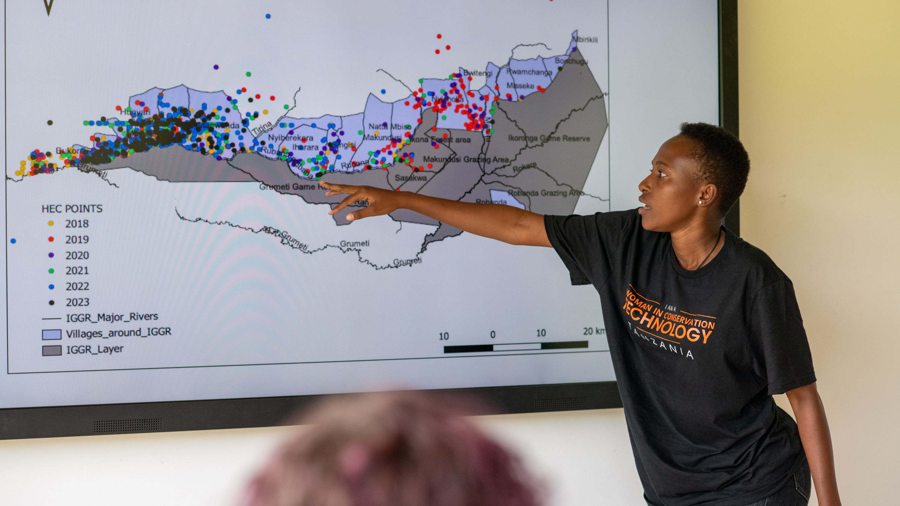
Integrated Land Use Planning

Integrated Land Use Planning involved strategically allocating land for agricultural and conservation purposes to balance human and wildlife needs. This comprehensive approach ensures sustainable land use that supports both community livelihoods and wildlife conservation. The planning was necessitated by the 10% fence plan, where 10% of beneficiaries' land was secured with an electrified short fence. Farmers utilized the secured land to incorporate skills honed from climate-smart agriculture training, maximizing production, while 90% of the land was left fallow for wildlife and livestock. Currently, a total of 129 acres have been secured by the 10% fence plan, with over 1,000 acres (90%) left as room for wildlife to roam. Up to date, there has been zero elephant conflict registered within the fences, securing crops and property with zero crop raids or property damage.

  • Collaborative Planning: Community members, conservationists, land use experts, and government officials were involved in the planning process. This inclusivity ensured that diverse needs and perspectives were considered, leading to more balanced and effective land use strategies.
  • Sustainable Practices: Land management practices that enhanced biodiversity, improved soil health, and strengthened ecosystem resilience were implemented. By focusing on sustainability, land use supported long-term ecological balance and productivity.
  • Policy Support: Policies that backed integrated land use planning were advocated for and developed. Strong legal and institutional frameworks were essential for the successful implementation and enforcement of land use plans.
  • Monitoring and Evaluation: Systems for continuous monitoring and evaluation of land use plans were established. Regular assessments helped adapt strategies to changing environmental conditions and community needs, ensuring that plans remained relevant and effective.
  • Inclusive Planning: Engaging a broad range of stakeholders in the planning process helped meet the needs of both people and wildlife. This approach fostered a sense of ownership and commitment, which was crucial for successful implementation and long-term sustainability.
  • Adaptive Management: Continuous monitoring and adaptation were vital for addressing evolving environmental and community needs. Flexibility in land use planning allowed for timely adjustments in response to new information or changing conditions.
  • Policy and Legal Frameworks: Strong policy support and legal frameworks were critical for the successful execution and sustainability of integrated land use plans. Effective policies ensured that plans were backed by law and had the necessary resources for implementation.
Integrated Land Use Planning

Integrated Land Use Planning involved strategically allocating land for agricultural and conservation purposes to balance human and wildlife needs. This comprehensive approach ensured sustainable land use that supported both community livelihoods and wildlife conservation. The planning was necessitated by the 10% fence plan, where 10% of beneficiaries' land was secured with an electrified short fence. Farmers utilized the secured land to incorporate skills honed from climate-smart agriculture training, maximizing production, while 90% of the land was left fallow for wildlife and livestock. Currently, a total of 129 acres have been secured by the 10% fence plan, with over 1,000 acres (90%) left as room for wildlife to roam. Up to date, there has been zero elephant conflict registered within the fences, securing crops and property with zero crop raids or property damage.

  • Collaborative Planning: Community members, conservationists, land use experts, and government officials were involved in the planning process. This inclusivity ensured that diverse needs and perspectives were considered, leading to more balanced and effective land use strategies.
  • Sustainable Practices: Land management practices that enhanced biodiversity, improved soil health, and strengthened ecosystem resilience were implemented. By focusing on sustainability, land use supported long-term ecological balance and productivity.
  • Policy Support: Policies that backed integrated land use planning were advocated for and developed. Strong legal and institutional frameworks were essential for the successful implementation and enforcement of land use plans.
  • Monitoring and Evaluation: Systems for continuous monitoring and evaluation of land use plans were established. Regular assessments helped adapt strategies to changing environmental conditions and community needs, ensuring that plans remained relevant and effective.
  • Inclusive Planning: Engaging a broad range of stakeholders in the planning process helped meet the needs of both people and wildlife. This approach fostered a sense of ownership and commitment, which was crucial for successful implementation and long-term sustainability.
  • Adaptive Management: Continuous monitoring and adaptation were vital for addressing evolving environmental and community needs. Flexibility in land use planning allowed for timely adjustments in response to new information or changing conditions.
  • Policy and Legal Frameworks: Strong policy support and legal frameworks were critical for the successful execution and sustainability of integrated land use plans. Effective policies ensured that plans were backed by law and had the necessary resources for implementation.
Registration and licensing, controls, and inspection

As a key measure to raise transparency within small-scale and artisanal fisheries, a robust registration and licensing system needs to be put in place. It is advised to introduce mobile, and if possible, community-led, on-site licensing initiatives, providing immediate support for licensing with registered tax numbers. This enhances the accessibility of the licensing process and compliance among fishers, due to a sense of community ownership. In cooperation with a dedicated governmental body, such as the Department of Fisheries and the local research institute, a digital management system should be developed. This central database helps to monitor licenses and registrations from multiple locations and thus enables conclusions to be drawn about the status of fish populations.

Controls and inspections are key principles of curbing IUU fishing. Improving the quality of patrols through specialized training for inspectors is essential to monitor fishing activities directly on board or after landing. Additionally, processors are encouraged to conduct self-inspections to prevent the processing of undersized fish and enforcing regulations in their businesses, thereby reducing reputational risks in the industry. The development and / or revision of standard operating procedures for these controls ensures that they remain relevant and effective in the face of changing IUU fishing practices.

Community-based management structures and sensitization of stakeholders

In tandem with the technical measures, building cooperative and community-based management structures has proven to be very successful. Such communities establish rules and regulations for accepted fishing methods but also facilitate stakeholder engagement to encourage local fisherfolk and associations to participate actively in fisheries management. Training programmes for the management structures focusing on organizational and technical capabilities are essential, equipping beneficiaries with the necessary skills to sustainably manage their waterbodies. In certain regions, the approach has included restructuring local management systems into cooperatives. This ensures that they have legal status and a well-defined management plan, thereby validating their operations. It also improves their ability to manage resources and increases their access to financial support through various funding opportunities.

Sensitization of stakeholders and the general public is another major activity in the context of combating IUU fishing. Information campaigns, such as videos explaining data collection at landings and the role of inspectors, contribute to raising awareness about the importance of sustainable fishing practices and the dangers of IUU fishing. These campaigns can be spread through national television, social media platforms or radio programmes to reach a wide audience and foster compliance and accountability. Public engagement initiatives, like consultation workshops, are essential for disseminating information on licensing, legislation, and the consequences of non-compliance. Especially focus group discussions further strengthen a sense of responsibility among fishers. Key factors for success include integrating local knowledge, establishing clear and enforceable regulations, and raising awareness of the consequences of compliance (sustainable fish stocks) and non-compliance (penalties).

Potential risks such as resistance to change, insufficient funding, and the complexity of monitoring vast and remote fishing areas need to be continually addressed through adaptive management and stakeholder collaboration.

Regular Evaluations

To ensure that fish production supported by the GP Fish is an accessible protein source also for the most vulnerable, GP Fish regularly tracks fish prices and the share of total production accessible to the food insecure population. According to the conducted surveys 90 %, 58 %, 84 %, and 99 % of farmed fish is accessible for the food insecure population in Madagascar, Malawi, Zambia, and Cambodia respectively (status 2023). These numbers again highlight the potential of extensive and semi-intensive aquaculture techniques to supply affordable protein and nutrients in areas with a high share of vulnerable people.

Integrated Land Use Planning

The project strategically allocated land for agricultural and conservation purposes to balance human and wildlife needs. This comprehensive planning ensured sustainable land use that supported both community livelihoods and wildlife conservation. Farmers cultivated their lands using the skills from Climate-Smart Agriculture (CSA) training, resulting in improved harvests with zero threats from elephants and other wildlife, making the 10% fence plans 100% effective. The remaining 90% of the land was used as fallow for wildlife and farmers' livestock, bringing a sense of wildlife-livestock integration. All farmers received dam liners for water pans and collected water for livestock and farming. This model brought a sense of integrated land use with a win-win benefit for both wildlife and communities. Sustainable practices were promoted, and policy support was advocated to back the integrated land use plans legally and institutionally. Continuous monitoring and evaluation systems were implemented to adapt and improve the plans over time.

  • Collaborative Planning: Community members, conservationists, land use experts, and government officials were involved in the planning process to ensure all perspectives and needs were considered.
  • Sustainable Practices: Land management practices that enhanced biodiversity, soil health, and ecosystem resilience were promoted and implemented.
  • Policy Support: Policies that supported integrated land use planning were advocated, ensuring legal and institutional backing for the plans.
  • Monitoring and Evaluation: Continuous monitoring and evaluation systems were implemented to adapt and improve land use plans over time.
  • Community Engagement: Regular meetings and workshops were held to engage the community in the planning process and ensure their buy-in and cooperation.
  • Data-Driven Decision Making: GIS mapping, surveys, and historical data analysis were used to make informed decisions about land allocation and management practices.
  • Training and Capacity Building: Community members were trained in sustainable land use practices to ensure long-term adherence and success.
  • Resource Allocation: Adequate resources, including funding and technical support, were secured to facilitate the implementation and maintenance of the land use plans.
  • Water Management: Provision of dam liners for water pans ensured adequate water collection for livestock and farming, supporting sustainable agricultural practices.
  • Inclusivity: Inclusive planning processes that involve all stakeholders ensure that the needs of both people and wildlife are met, fostering coexistence and sustainability.
  • Adaptability: Continuous monitoring and adaptation are necessary to address changing environmental and community needs effectively.
  • Policy and Legal Support: Strong policy support and legal frameworks are essential for the successful implementation and sustainability of integrated land use plans.
  • Community Ownership: Engaging the community and ensuring their ownership of the planning process leads to better compliance and success.
  • Data Utilization: Accurate data collection and analysis are crucial for making informed decisions and targeting interventions effectively.
  • Sustainable Practices: Promoting and implementing sustainable land management practices enhances ecosystem resilience and supports long-term community livelihoods.
  • Capacity Building: Training and capacity building are vital for ensuring that community members can sustain and manage the land use plans independently.
  • Integrated Benefits: The integrated land use model provided a win-win benefit for both wildlife and communities, promoting coexistence and mutual support.
Community Engagement and Training on Climate-Smart Agriculture

The project trained farmers in climate-smart agriculture (CSA) and permaculture farming practices to improve yields and sustainability. This involved practical training sessions, demonstration plots, and ongoing support to help farmers adopt and sustain new practices. Training programs were developed and delivered on CSA techniques, including soil conservation, water management, and sustainable crop choices.

Farmers were trained by experts from the Kenya Agricultural and Livestock Research Organization (KALRO), with a deep concentration on dry crop farming such as cowpeas, green grams, millet, and cassava. They were also linked to KALRO for the procurement of certified seeds for planting. The training was conducted before the onset of the long rains season, allowing farmers to apply the skills garnered just in time for planting before the rains started. County Agriculture officers attended the sessions to drum up support from the government.

Demonstration farms were established within the community to showcase best practices and allow farmers to see the benefits firsthand. Support networks and farmer groups were created for sharing knowledge, resources, and experiences, fostering peer learning and support. Necessary resources such as seeds, tools, and organic fertilizers were provided to help farmers implement new techniques.

  • Training Programs: Comprehensive training programs on climate-smart techniques were developed and delivered. These programs included soil conservation, water management, and sustainable crop choices. Practical sessions and workshops were conducted to ensure farmers understood and could apply these techniques effectively.
  • Expert Training: Farmers were trained by experts from KALRO, focusing on dry crop farming such as cowpeas, green grams, millet, and cassava. This specialized training ensured that farmers had the knowledge to successfully grow crops suited to their environment.
  • Certified Seed Procurement: Farmers were linked to KALRO for the procurement of certified seeds, ensuring access to high-quality planting materials.
  • Seasonal Timing: The training was conducted before the onset of the long rains season, allowing farmers to apply their new skills in a timely manner for planting.
  • Government Support: County Agriculture officers attended the training sessions, providing government support and increasing the program's credibility and reach.
  • Demonstration Farms: Demonstration farms were established within the community to showcase best practices. These farms allowed farmers to see the benefits of climate-smart agriculture firsthand, enhancing their understanding and encouraging adoption of new practices.
  • Support Networks: Networks and farmer groups were created for sharing knowledge, resources, and experiences. These networks fostered peer learning and support, providing a platform for farmers to discuss challenges, share solutions, and learn from each other’s experiences.
  • Monitoring and Evaluation: Tsavo Trust and KALRO developed and implemented systems to monitor the progress of farmers adopting climate-smart practices. Regular evaluations were conducted to assess the effectiveness of the training programs and make necessary adjustments.
  • Partnerships: Partnerships with local communities and government agencies provide additional support and resources. These partnerships enhanced the reach and impact of the training programs.
  • Hands-on training and demonstration farms enhanced learning and adoption of new practices. Practical experience and seeing the benefits firsthand were crucial for encouraging farmers to adopt climate-smart techniques.
  • Ongoing support and mentorship were important for sustained agricultural improvement and innovation. Continuous engagement and guidance helped farmers overcome challenges and maintain their commitment to new practices.
  • Peer networks and community groups enhanced the sharing of knowledge and resources, improving overall adoption rates. Collaborative learning and support among farmers fostered a community-wide shift towards climate-smart agriculture.
  • Access to necessary resources was crucial for the successful implementation of new techniques. Providing seeds, tools, and organic fertilizers ensured that farmers could effectively adopt and sustain climate-smart practices.
  • Involving agricultural experts ensured that the training programs were based on the latest research and best practices. Their expertise added credibility and depth to the training, enhancing its effectiveness.
  • Regular monitoring and evaluation allowed for continuous improvement of the training programs. Feedback from farmers and ongoing assessments helped refine the approach and address any issues promptly.
  • Building partnerships with local communities and government agencies provided additional support and resources. These partnerships enhanced the training programs' reach and impact, ensuring more farmers could benefit from climate-smart agriculture.
Mapping, Needs Assessment, and Data Collection

Thorough assessments were conducted to identify human-wildlife conflict (HWC) hotspots and ensure the project addressed the most critical areas. This involved gathering quantitative and qualitative data to make informed decisions about fence placement and other interventions. GIS mapping, surveys, and interviews were utilized to understand current land use patterns, wildlife corridors, and areas experiencing frequent HWC. Surveys were also conducted with households to establish threats, crop and property destruction, and the amount of harvest farmers were getting. The results of the needs assessment were submitted to the Kamungi Board, who used this information to select three final beneficiaries of the 10% Fence Plan. Their decision was then passed through a public participation community meeting, where members present endorsed the identified beneficiaries.

  • GIS Mapping: Geographic Information Systems (GIS) were employed to map current land use patterns, wildlife corridors, and areas experiencing frequent HWC. This technology provided detailed spatial data that was crucial for planning and implementing the 10% Fence Plan effectively.
  • Surveys and Interviews: Structured surveys and interviews with community members were conducted to gather data on HWC incidents, economic losses, community needs, and the amount of harvest farmers were getting. This approach ensured that the project was grounded in the actual experiences and requirements of the affected communities.
  • Historical Data Analysis: Historical data on HWC incidents were reviewed to identify trends and predict future conflict zones. This analysis helped in understanding long-term patterns and preparing proactive measures.
  • Community Involvement: Local community members were involved in data collection processes, which helped in building trust and ensuring that the data gathered was comprehensive and accurate.
  • Technology Integration: Advanced data collection tools and software (kobotool box) were utilized to streamline the data gathering and analysis processes, improving efficiency and accuracy.
  • Board Engagement: The Kamungi Board reviewed the needs assessment results and selected three final beneficiaries of the 10% Fence Plan. This ensured that decisions were made by trusted local authorities.
  • Public Participation: The selection of beneficiaries was endorsed through a community meeting, ensuring transparency and community buy-in.
  • Accurate data collection and mapping were crucial for targeting interventions effectively.
  • Community input provided valuable insights into local challenges and needs, ensuring that the project was responsive and relevant.
  • Involving local community members in data collection fostered ownership and increased the accuracy of the information gathered.
  • Utilizing technology improved the efficiency and accuracy of data collection and analysis processes.
  • Regular updates to mapping and data collection ensured that interventions could adapt to changing conditions, maintaining their relevance and impact.
  • Historical data analysis provided important context and helped in predicting future conflict zones, enabling proactive planning.
  • Effective communication of data and findings to the community and stakeholders built trust and facilitated better decision-making.
  • Continuous learning and adaptation based on data analysis allowed for ongoing improvement of intervention strategies.
  • Engagement of the Kamungi Board in the beneficiary selection process ensured that decisions were made by trusted local authorities.
  • Public participation in endorsing the beneficiaries built community trust and support for the project.
Results

Under the application of the trap for intermittent harvest, the best results were achieved with the following combination of variables: maize bran (supplementary feed) x maize bran (trap bait) x O. Shiranus (species) x 2 fish/m2 (stocking density).

The total yields under this combination were 25 percent higher than in the control group with single batch harvest. A higher stocking density (3 fish/ m2) led to a slightly higher total harvest in the control group, but to a lower net profit. The use of pellets reinforced both effects and was the least economical.

Results from the on-farm trials (see Figure 1) have demonstrated the functionality and the excellent catch effect of the traps. Over the three-month on-farm trial period, the trap was used 2 to 3 times a week and a total of 27 times. On average, around 120 small fish – an equivalent of 820 grams – were caught each intermittent harvest. With the use of the trap, all households reported that they now eat fish twice a week. Before that, fish consumption was between one and four times a month.

The benefits:

  • Reducing the competition for oxygen and food among the fish in the pond and thus measurable increase in yield.
  • Improved household consumption of small, nutritious fish and better cash flow.

Success factors:

  • Traps are easy and inexpensive to build (USD 3).
  • Traps are easy to use, also for women.
  • Directly tangible added value thanks to easy and regular access to fish.


Examples from the field

Overall, the user experience of households engaged in the on-farm trials was very positive:

As a family we are now able to eat fish twice and sometimes even three times a week as compared to the previous months without the technology when we ate fish only once per month.” (Doud Milambe)

Catching fish is so simple using the fish trap and even women and children can use it.” (Jacqueline Jarasi)

It is fast and effective compared with the hook and line method which I used to catch fish for home consumption that could take three to four hours but to catch only three fish and thus not enough for my household size.” (Hassan Jarasi)

Results

Under the application of the trap for intermittent harvest, the best results were achieved with the following combination of variables: maize bran (supplementary feed) x maize bran (trap bait) x O. Shiranus (species) x 2 fish/m2 (stocking density).

The total yields under this combination were 25 percent higher than in the control group with single batch harvest. A higher stocking density (3 fish/ m2) led to a slightly higher total harvest in the control group, but to a lower net profit. The use of pellets reinforced both effects and was the least economical.

Results from the on-farm trials (see Figure 1) have demonstrated the functionality and the excellent catch effect of the traps. Over the three-month on-farm trial period, the trap was used 2 to 3 times a week and a total of 27 times. On average, around 120 small fish – an equivalent of 820 grams – were caught each intermittent harvest. With the use of the trap, all households reported that they now eat fish twice a week. Before that, fish consumption was between one and four times a month.

The benefits:

Reducing the competition for oxygen and food among the fish in the pond and thus measurable increase in yield.

Improved household consumption of small, nutritious fish and better cash flow.

Success factors:

Traps are easy and inexpensive to build (USD 3).

Traps are easy to use, also for women.

Directly tangible added value thanks to easy and regular access to fish.


Examples from the field

Overall, the user experience of households engaged in the on-farm trials was very positive: “As a family we are now able to eat fish twice and sometimes even three times a week as compared to the previous months without the technology when we ate fish only once per month.” (Doud Milambe)


Catching fish is so simple using the fish trap and even women and children can use it.” (Jacqueline Jarasi)


It is fast and effective compared with the hook and line method which I used to catch fish for home consumption that could take three to four hours but to catch only three fish and thus not enough for my household size.” (Hassan Jarasi)