4. Mission to monitor the implementation of agreements for access to the PNC as part of the worship of sacred sites in the Bouna and Nassian sectors, and to scale up to all villages on the outskirts.

Following the signing of access agreements to the PNC for the worship of sacred sites, and after months of implementation, a monitoring mission was carried out in the field to identify the difficulties encountered in implementing the agreements and how to remedy them, the planning of visits to sacred sites in the PNC by all partner villages, and the status of villages that had not made any visits. In addition to the monitoring mission, discussions were held with the customary authorities of the villages bordering the Tehini sector, to gather information on the possibility of extending the sacred site access agreement to the Tehini sector. Twenty (20) sacred sites were inventoried in collaboration with communities in seven (07) villages in the Tehini sector, where certain communities have expressed the need to access sacred sites within the PNC for their worship.This mission was led by the OIPR/DZNE (the Chargé d'Etudes at the DZNE, the Chiefs of the Bouna, Nassian and Tehini sectors, rural animators and community relays from the sectors concerned) and the Biodiversity Expert from GIZ/Pro2GRN.

During the follow-up, it was noted that some villages had performed adoration in the PNC to implore the manna (35 adoration activities for 03 of the 17 villages that had signed the conventions). As for the other villages, they hailed the convention's initiative and added that, for the most part, no events requiring adoration had occurred since the conventions were signed. During the discussions, some villages pointed out that there had been a break between them and their manna for a very long time. As a result, there is no immediate need for worship. For them, sacrifices will have to be made before they can resume their ancient practices.

This stage enabled the identification of new partner villages, namely 08 (eight) villages in the Tehini sector (31 sites identified) and 04 (four) villages in the Nassian sector (08 sites identified), which have sacred sites in the PNC and would welcome collaboration in the worship of sacred sites.

In addition to the mission, data was collected from the local population in order to compile a list of useful plants that had disappeared, and the reasons for this in their territories.

The formalization of access to sacred sites has enabled local populations to renew contact with their spirits. However, for some villages that had abandoned these practices, the resumption of worship requires material and financial resources. New partnerships also need to be signed with new sites identified in other villages. These agreements build trust between managers and local populations, opening up new prospects for collaboration, such as the participatory preservation of utilitarian plants and their domestication for future generations.

Integrated Land Use Planning

Integrated land use planning strategically allocated land for agriculture, conservation, and human settlements, balancing the needs of both people and wildlife. After training on climate-smart agriculture (CSA) and continued sensitization on wildlife and habitat conservation during monthly community meetings facilitated by the BIOPAMA project, the integrated land use approach was on its way to being achieved. The beneficiaries of the 10% Fence Plan maximized the allocated 10% for agriculture by planting certified seeds best suited for the climatic conditions, resulting in high yields. At the same time, the remaining 90% of the land was effectively utilized by wildlife and livestock, creating the much-needed balance in Kamungi Conservancy. This approach benefited both the communities and wildlife by promoting sustainable land use that supported livelihoods and conservation efforts.

  • Collaborative Planning:
    A multi-stakeholder approach was essential for the success of integrated land use planning. Community members, conservationists, agricultural experts, and government officials were actively involved in the planning process, ensuring that the needs of all parties were considered. The inclusion of indigenous knowledge and the contributions made during monthly community meetings, facilitated by the BIOPAMA project, fostered a sense of ownership and commitment from local communities. This collaborative approach ensured that land was allocated for both agricultural and wildlife purposes, balancing the coexistence of people and nature.
  • Sustainable Land Management Practices:
    Training on climate-smart agriculture (CSA) empowered community members to adopt practices that enhanced agricultural productivity while conserving the environment. Certified seeds were used to optimize crop yields in the 10% of land allocated for agriculture under the Fence Plan. Simultaneously, sustainable grazing and habitat management ensured that the remaining 90% of the land was beneficially used by wildlife and livestock. This approach helped maintain biodiversity, supported ecosystem resilience, and contributed to soil health and water conservation.
  • Zoning and Mapping:
    Clear zoning and mapping strategies were implemented, designating areas for agriculture, wildlife, and livestock use. The 10% allocation for farming was carefully selected based on land suitability for crops and climatic conditions, ensuring maximum productivity. The remaining 90% was preserved for wildlife and grazing, providing a balanced and functional land use system. Community land mapping allowed for real-time monitoring of land use, helping to maintain the ecological integrity of Kamungi Conservancy.
  • Economic Incentives:
    Economic benefits played a critical role in ensuring community participation and adherence to the land use plan. The high agricultural yields from the 10% Fence Plan, achieved through the use of climate-smart practices and certified seeds, provided direct financial benefits to the local communities. Additionally, Tsavo Trust’s community support initiatives—such as the provision of solar home systems, energy-saving cook stoves, dam liners for water conservation, scholarship and education support, and health support—further incentivized communities to maintain the balance between conservation and development. These incentives significantly contributed to the overall success of the integrated land use approach by improving livelihoods while promoting sustainable land management practices.
  • Capacity Building and Training:
    The capacity-building initiatives led by the BIOPAMA project were instrumental in training community members on climate-smart agriculture and wildlife conservation. These trainings, along with continued sensitization efforts during the monthly community meetings, ensured that communities were well-equipped with the knowledge and skills to implement sustainable land management practices. The strong foundation of knowledge led to more effective land use, increased agricultural productivity, and improved wildlife conservation efforts.
  • Inclusivity Drives Success:
    Engaging all stakeholders—community members, conservationists, agricultural experts, and government officials—was essential to the success of the integrated land use planning. The participatory approach ensured that diverse needs were considered, fostering community ownership and long-term adherence to the plan. The inclusion of local knowledge, reinforced by continuous sensitization through the BIOPAMA project’s community meetings, contributed significantly to the plan’s success.
  • Climate-Smart Agriculture is Key to Productivity:
    The use of certified seeds and climate-smart agricultural practices under the 10% Fence Plan led to significantly higher yields, demonstrating that sustainable farming techniques can greatly benefit local communities. The successful integration of these practices allowed the community to benefit economically while simultaneously contributing to the conservation of surrounding ecosystems.
  • Economic Incentives Encourage Community Buy-in:
    Direct economic benefits, such as the provision of solar home systems, energy-saving cook stoves, dam liners, scholarship and education support, and health services, played a crucial role in encouraging community adherence to the land use plan. These livelihood projects, supported by Tsavo Trust, reinforced the balance between conservation and development, ensuring that communities saw tangible benefits from their participation in conservation efforts. This linkage between conservation and improved living standards fostered long-term support for the plan.
  • Balancing Land Use Enhances Coexistence:
    By designating 10% of the land for agriculture and reserving 90% for wildlife and livestock, the land use plan successfully created a balance that supported human livelihoods while maintaining wildlife habitats. This careful land allocation reduced human-wildlife conflicts and ensured the sustainable use of natural resources, promoting long-term coexistence.
  • Policy and Legal Frameworks Provide Stability:
    Strong policy backing and legal support were instrumental in enforcing the integrated land use plan. The collaboration with local governments ensured that land use boundaries were respected and violations addressed. This legal framework created a foundation for sustained conservation efforts and development.
  • Adaptability is Essential for Sustainability:
    The continuous monitoring and evaluation of land use through GIS mapping and community feedback mechanisms allowed for adaptive management. This flexibility ensured that the land use plan could respond to changing environmental conditions and socio-economic needs, making it more resilient and sustainable in the long term.
Biodiversity Monitoring

The establishment of the Golden Monkey Monitoring and Research Base at Northwest University and the Zhouzhi Substation for the National Field Scientific Observation and Research of Biodiversity for Giant Pandas and Golden Snub-nosed Monkeys, in collaboration with various institutions such as the Shaanxi Institute of Zoology, Northwest A&F University, Beijing Forestry University, and Northwest University, serves as an internship base for graduate and doctoral students. These partnerships facilitate joint efforts in wildlife surveys and other scientific endeavors, thereby promoting high-quality development within the region.

Research projects have been implemented to conduct extensive surveys, resulting in the creation of a comprehensive database of rare and protected species such as the Giant Panda, Golden Snub-nosed Monkey, Golden Takin, Himalayan Yew, and Kingdonia uniflora. This has led to the compilation of 13 specialized survey and monitoring reports, including the "Giant Panda and Its Habitat Monitoring Report" and the "Golden Snub-nosed Monkey Survey Report," earning two second-place awards for scientific and technological advancements from the Shaanxi Forestry Department.

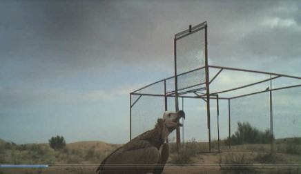
Since 2012, infrared cameras have captured approximately 40,000 photographs and 5,000 video clips of rare wildlife activities, including Giant Pandas and Golden Snub-nosed Monkeys. Remarkably, the Zhouzhi Nature Reserve has recorded three leopards foraging together on three occasions, as well as footage of two wild Giant Pandas playing, and the first recorded appearance of a brown Giant Panda. Additionally, images of the Asiatic Golden Cat have been documented in various areas within the jurisdiction. In 2019, footage of the Golden Takin garnered the "Best Video Award" on CCTV's "Eyes of the Secret Realm." In 2023 alone, the effectiveness of biodiversity conservation efforts has been reported 16 times by provincial and national-level media.

Establish Management Systems and Technical Procedures

1.Establishment of Nanshan National Park Patrol Technical Regulations: The guidelines have clarified the purposes, types, procedures, and documentation requirements for patrols. Standards for establishing patrol teams and planning patrol schedules and routes have been defined. Key plots, rare tree species, and endangered animals within the national park are under focused conservation, with any issues being reported promptly. Additionally, the regulations help in disseminating forestry policies and regulations, enhancing the community's awareness and participation in resource protection.   2. Issuance of the "Nanshan National Park Key Protected Terrestrial Wild Animals Damage Compensation Regulations": This policy specifies the circumstances, eligible compensation recipients, compensation authorities, and procedures. It provides necessary legal support and enforcement for citizens, legal persons, or other organizations that suffer losses due to the infringement of key protected terrestrial wild animals within the national park.

  1. Management Support: The administrators recognize the necessity of this work and have organized professional technical staff to develop technical procedures and management systems based on the actual situation of Nanshan National Park. These have been published after several discussions and studies within the management bureau. 2.Technical Support from the Administration: The management bureau has established a department responsible for patrol work and employs professional technical workers to guide and supervise the effective implementation of technical management systems and procedures. There are multiple conservation stations within the national park's boundaries, and several local patrol officers who are familiar with the terrain and knowledgeable about wildlife protection have been hired. 3.Adequate Funding: The management bureau and local government provide funding and subsidies for the patrol work, ensuring that the patrol teams have sufficient financial support.
Education and Advocacy

- Provide training workshops focusing on sustainable fishing methods, resource management, and the legal ramifications of illegal fishing practices. 

- Work with local authorities to educate them about the role of the associations and the necessity of enforcing regulations that protect their members and the ecosystem. 

Every descent into each village, our team was always accompanied by staff from the regional directorate of fishing and the blue economy (DRPEB). Through fieldworks, they took the opportunity to raise awareness about fishing regulations, reminders of laws and procedures as well as respect for fishing calendars for various fishery resources.

Operational Guidelines

- Create operational guidelines that detail how the association will manage fishing activities, including rules about fishery zones, seasonal closures, and sustainable practices. 

   - Establish a monitoring system to ensure compliance with these rules, reinforcing accountability among members. 


The fishermen cards, which are essential for lawful fishing, operate as a crucial incentive; those who do not secure membership within their respective associations will be ineligible to receive these cards, exposing them to potential legal repercussions.

Through these associations, local fishermen gain official membership status, which is a prerequisite for obtaining their professional fishermen cards. 

Registration and Credentialing

- Develop a procedure for registering members in the association, ensuring they meet all local requirements. 

- Guide association members through the process of obtaining their fishermen cards, emphasizing its importance as a legal requirement for their livelihood. 

-Taking fishermen identities, information and photo

Formation of Associations

- Conduct community meetings to gather fishers and discuss the benefits of forming local associations. 

- Facilitate the establishment of association statutes that outline membership requirements, roles, and responsibilities. 


This mechanism serves dual purposes: it not only regulates access to the fishing grounds by preventing unauthorized fishing activities from transient fishers but also fosters a sense of community ownership among the local population. 


As they each have their own statutes and internal regulations but also their common fund allowing their association to develop 

Conception of one action plan with the Regional Directorate of Fisheries and Blue Economy (DRPEB) of Diana

In close collaboration with the Regional Directorate of Fishing and the Blue Economy of Diana, with whom we developed an action plan for the implementation of all the activity, mutually approved and signed.

It is always necessary to establish synergy with the partners concerned in order to be able to implement the planned activities effectively and efficiently.

Capture and Release of Vultures

Collecting data will be done by catching and releasing vultures by using a capturing cage. The capturing cage is progressively being built at a site where animal carcasses are regularly placed, this site is called "Vulture Restaurant". Vultures will then be fitted with GPS trackers, tagged, and released, allowing to record their movements and possibly locate their breeding grounds. Samples (blood, swabs, faeces, ectoparasites, and feathers) will be collected to assess the health of the individuals and check their exposure to diseases, environmental lead and possible NSAID contaminants. Samples will also be preserved for future conservation genetics.

At the current and initial stages, the important factors needed for a capture and release operation to work is by making sure the vultures are comfortable enough to enter the capturing cage and making sure the capture and release operation is done quickly on a day when it is cooler, such as in the winter season. 

  1. When establishing a capturing cage for vultures, the use of camera traps is very useful. Camera traps allow to record elusive vultures and their adaptation to a newly built structure, such as a capturing cage.


  2. Depending how skittish the vultures are, it is important to plan how the capturing cage door will close on the day where a capture and release operation will take place. These are a couple of possible options, remotely from a distance with a remote control or manually with a rope. It is important to implement a mechanism to ensure the capturing cage door does not slam down hard and quickly inorder to avoid vulture injury.