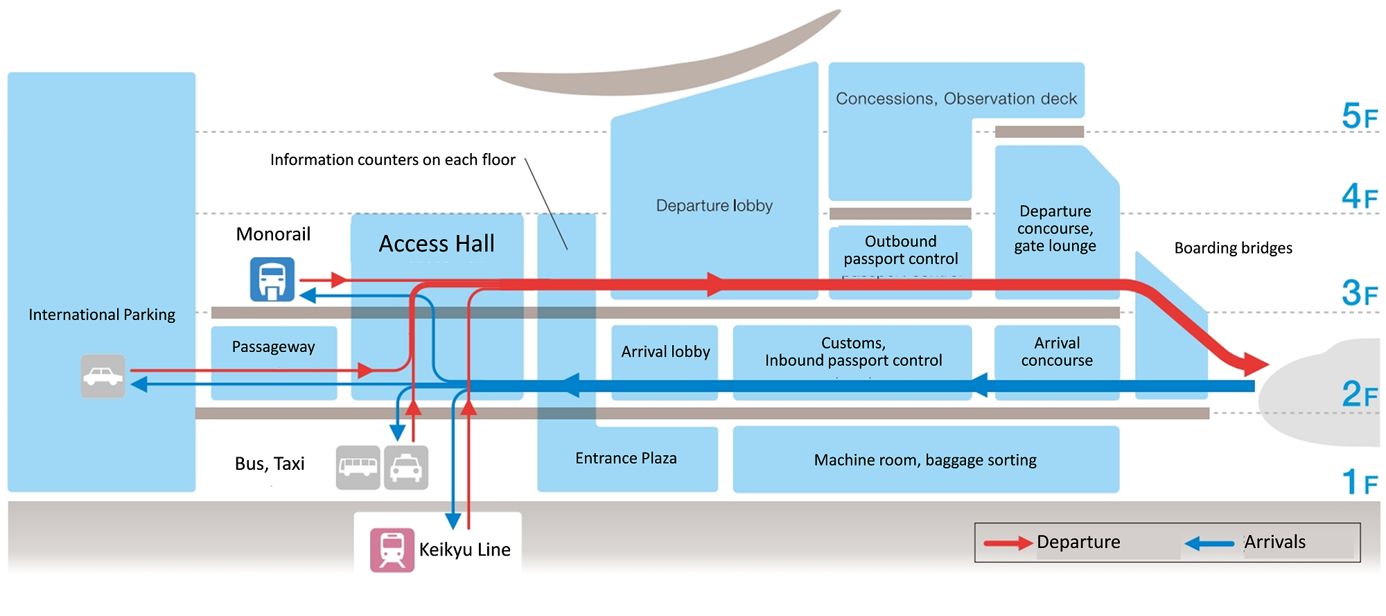
Integrated Access to and from Urban Centers

The design of the airport itself is half of the success equation - how to ensure seamless door-to-door travel experience for various people including the elderly and disabled is a key. Haneda International Airport Terminal is directly connected to the city’s major urban centers by two railway companies. When the new terminal and stations were built, TIAT and these two railway companies collaborated to get rid of physical barriers across facilities for people with mobility disadvantages. For example, a hall in the terminal allows passengers to directly access to departure/arrival lobbies, public transportation services (e.g., Monorail, railway, buses, and taxies) and a car parking area via flat and straight paths. Several large-size elevators set in the station can also carry a large volume of passengers between the platforms and the arrival/departure floors. A railway line redirected the guideway from the existing platform at the domestic terminal to the second floor of the international terminal to produce flat passenger access from the station to the departure lobby. In addition, the both railway lines introduced movable step boards that bridge train vehicles and platforms for wheelchair users, and platform screen doors for passengers’ safety.

  • Coordination of facility design with railway companies providing access to the airport

Integrated access design between an airport terminal, ground transportation systems, and urban centers is critical for travelers with disabilities. In particular, it is essential to eliminate all types of level differences and floor gaps that can cause stress and hamper passengers from having seamless door-to-door travel experiences. Incorporating a centralized hall into the terminal benefits all users, as it enables smooth transfers among different transportation modes with barrier-free paths and, in turn, mitigates pedestrian congestion at airports.

Thoughtful and Interactive Design Process

The universal design committee organized approximately forty universal design workshops and reflected the opinions collected from a wide range of users to the detailed drawing of the terminal. The members also visited existing airport facilities and used mock-ups to assess the effect of the design plan. As a result of these joint design efforts, the terminal successfully provides seamless access to public transportation, especially railways. It also progressively introduced world-class terminal facilities with the Universal Design concept; Multipurpose toilets, boarding bridges, and versatile concierge service and communication devices exemplify its novelty.

  • Establishing a universal design committee as a coordinating board
  • Organizing universal design workshops that allow governments and private companies to gather more input from airport users into design of facilities.
  • Strong private players (NGOs, community development conference, etc.) active in promoting universal design

Airport terminals require several special facilities related to a series of air travel procedures, such as security checks, embarking and disembarking, immigration, and lengthy waiting times. To increase access to the terminal for everyone, the usability of all facilities needs to be scrutinized and should reflect the voices from a range of actual users.

Implementation of a GPS navigation system

During this survey, the Nature Reserve's launch was made available to study the shallow coastal waters. With a length of 8 meters
equipped with sounder, GPS and radar. To complement this equipment and obtain the finest possible accuracy, the launch was equipped with a differential GPS operating in real-time WAAS/EGNOS metric mode, with an accuracy of the order of 1 to 2 meters. An RTK (Real Time Kinematic) system was used for greater precision during the investigations. Its beacon was placed on the roof of the Cap Béar semaphore, close to the survey area. This is a method whereby GPS signal corrections are transmitted in real time from a reference receiver, located at a precise known point, to the boat's mobile receiver. Accuracy can then be
centimeters if you are close to the reference receiver.

It is essential to identify the partners who can meet the objectives set by the manager. Appropriate resources and local knowledge are also essential to avoid wasting time. Regular exchanges with the partners involved in the project will help to obtain answers and anticipate problems.

It is essential to define very precise specifications so that the monitoring meets the expectations of the service provider, but also so that the use of these new technologies does not distort the comparison with the results obtained during previous monitoring.

Use of side-scan sonar to map seagrass beds in the Cerbère-Banyuls Marine Nature Reserve

For several years now, numerous studies have been carried out on Posidonia meadows in the Reserve. Each study provided increasingly accurate results, but left a number of gaps. The Reserve decided to fill these gaps by simultaneously using several innovative systems, such as side scan sonar (SBL). This sonar provided an overview of the characteristics of the seabed. The integration of Acoustic Systems for Automatic Bottom Classification (SACLAF) data from previous missions into this project will have been a complementary means to the acoustic scanning imaging system, providing an element of data validity. The reliability of the results was assessed using GoPro® cameras. All data were processed using ArcGIS version 10.3 geographic data processing software.

Acoustic data were acquired using a C-MAX CM2 EDF side scan sonar and processed using Hypack 2012 software. In order to obtain the expected results, i.e. precise mapping of the Reserve's seagrass beds and a comparison of the evolution of the seagrass beds in relation to the last surveys, perfect knowledge of this equipment and of the study area is required.

- Regular exchange and sharing with service providers

- Competence of equipment users

- Ability to process data

- Realization of ground truth

Upscaling agroecological practices through joint networking

The various zones engage in joint zonal networking activities such as having joint learning and sharing forums, joint farmer exchange visits, joint exhibitions, joint proposal writing and implementation among others. This enhances learning and sharing amongst the network members as this provides an opportunity to interact. Through the zonal initiative, members are able to apply for consortium funds are this enhances their level of winning the funds. For instance,  five members from Nairobi and Central zone are currently implementing a joint project by the name Food Security and Livelihoods (FOSELI). This is a way of creating synergy and doing things that one member organization cannot do alone.

PELUM Kenya secretariat supports zonal initiatives in its programmes and promotes a suitable ground for members to engage each other

PELUM Kenya has recruited zonal Networking Coordinators who are engaged in enhancing networking amongst members in a zone

The zonal members hold periodic meetings to discuss various issues regarding theis zones as a way of reflecting and improving

There is need to plan early especially for activities that engage various members so that there is time to intergaret in the organizational plans and for effectiveness

There is need for members to be engaged from the planning stage to the implementation stage to minimize conflicts


Clustering member organizations from one region in one zone

The decentralised zonal networking operates in such a manner that member organizations from a certain geographical region are clustered together in one zone. This brings together members who are experiencing similar challenges based on their geographical locations together.

The members are able to engage in decision making process and representation in various initiative in the national network is based on zonal representation and decisions

Members in the same zone are therefore able to meet more in a cost effective manner as limited time and resources is require to engage a fellow member organization in the same zone

The members in a certain zone are also able to engage in joint advocacy initiatives in their various regions

By clustering members in a certain geographical region, the members are able to know each other, interact more and engage in activities that enhance learning and sharing amongst themselves

Participatory processes that engage the zonal emmbers: Various zones are given the mandate to make decisions that involve the zone and are also represented in various intitiaves by the national secretariats

There is need to encourage zonal members in decision making for ownership and sustaiability purposes

Land Owners in the Driver's Seat

In the case of Marugamemachi, a community development company manages a range of properties and services (e.g., commercial buildings, housing, tenants, car parking, and community bus operation). In contrast to such companies that in general often hire city officers or private executives to promote and coordinate redevelopment projects, all the staff are business professionals who have rich knowledge and experience in managing commercial buildings. Financially, 95% of the investment to the company comes from the private sector and the rest comes from the local government. This means that the involvement of local government is very limited in the management of the company. Nevertheless, several government subsidy schemes were utilized for the re-development project to reduce the amount of borrowing from banks, which resulted in a reduced financial burden for the land owners.

  • Government's understanding of themselves as "facilitators" "brokers" of the redevelopment initiative
  • Presence of a local body coordinating individual land owners (e.g. Community Development Company in this case - see project overview for details)
  • Professional expertise of a community development company on property and business service

Government financial support is important to implement capital-intensive redevelopment projects to reduce the financial burden and lower the risks for the group of small land owners leading the projects. However, in the case of private-based redevelopment efforts like this particular case, governments should not always be at the centerpiece in the decision-making process. Less government involvement encourages land owners to take initiatives, make immediate decisions, and expedite revitalization at their own risk and expense.

Strong Local Private Initiatives to Revitalize an Urban District

Historically, retailers along old shopping streets are both individual land owners and local business operators. Although a large-scale redevelopment project has a great potential to generate huge benefits to all the stakeholders, these land owners are often less cooperative with each other for protecting their own property rights. In the case of Marugamemachi, this issue was solved by land owners’ decision to lease their land use rights for the redevelopment project while retaining their property rights, with the strong initiative of local land owners themselves. Through this ownership arrangement, fragmented land lots with different owners were efficiently consolidated into a large parcel for redevelopment and leased to a community development company. Then, the company selectively invited new competitive tenants in consideration of a well-balanced mix of business types to make the place more attractive for customers.

  • Local leadership, both from the public and private, to serve as brokers to bring together land owners and various stakeholders 
  • Urban redevelopment law that allows to exchange land rights and also to separate the land use rights from the landownership

It is essential to strongly motivate all owners to redevelop by clarifying both potential project risks and investment returns and tightly unite them by sharing vision and goals of redevelopment. The strong will of local communities for redevelopment and the involvement of experts to support the redevelopment are also key factors for success.

Land Use Incentives

Under a market freehold system, it is not always easy for local planning departments to curb large shopping mall projects and gain control over individual land uses by zoning. When and where traditional planning and regulatory systems are not sufficient to manage land use and shape development, generous incentives (e.g., direct subsidies, tax reductions, and expedited reviews) may be needed to move new residents to the target districts and corridors.

  • Substantial assistance from the city government to provide direct subsidies, tax reductions and expedited reviews

It is critical for local governments to identify major property owners and involve powerful private developers in both capital projects and operation programs that aim to materialize the public vison of building a compact city in a profitable way.

Long-term Vision from Mayor Shared by Citizens

Holding one iconic vision with all citizens is essential to make long-term efforts in tarnsforming a city structure and synchronizing a variety of individual capital projects and operation programs delivered by several public-private stakeholders.

  • Strong committment from the Mayor
  • Frequent and continuous opportunities for dialogue with the citizens to transform the city's development vision into a "shared" vision by the people
  • Detailed operational programs to translate the vision to step-by-step actions

In order to transform a vision into reality, (1) Capital Projects with Multiple Funding Sources and (2) Successive Operation Programs is key.


More specifically: 


Capital Projects with Multiple Funding Sources: The vision of forming a compact city inevitably calls for major capital projects, such as public transit reinvestments and social infrastructure improvements. Small cities and peripheral towns under severe budget constraints need to combine multiple funding sources efficiently and consistently into a project finance scheme.


Successive Operation Programs:

The provision of modern infrastructure alone does not automatically lead to urban regeneration. “Placemaking” efforts need to be made for inducing value-added social interactions in the long run. Individual business owners and local commercial associations play a vital role in successively implementing a variety of urban operation and district management programs together with municipal governments and transit agencies.