Technical support and training

CCF provides a holistic digital ecosystem integrating landscape-scale technology, training and community engagement to drive meaningful change, contributing to GBF Target 20 – Strengthen Capacity-Building, Technology Transfer, and Scientific and Technical Cooperation for Biodiversity.

Launching in June 2025, the Protected Area Technician (PAT) Training Programme has been developed by CCF to empower local communities to protect nature.

This tailored programme is designed to build practical, in-demand skills that create real opportunities—from entry-level technician roles to long-term careers in leadership and consulting within protected areas. Co-developed with industry experts and rooted in local needs, the curriculum blends hands-on field training with applied conservation technology knowledge.

Participants will graduate with job-ready skills to support and maintain vital conservation tech infrastructure. They’ll also have the opportunity to earn a PAT Certification, with a pathway to a globally recognised Cisco Certification—unlocking even broader career potential in the conservation and tech sectors.

By investing in local talent, the PAT programme helps communities take a leading role in protecting the natural landscapes they call home.

Monitoring of impact will take place through the first cohort of learners, focusing on their career journeys and personal development outcomes

Centralising data for management and control

A visualisation platform for real-time protected area management, helping managers make informed, conservation-related operational decisions. A community of users is now sharing best practices and innovative concepts, engaging EarthRanger as it extends beyond just elephant protection to a diversity of wildlife, ecological and community applications.

CCF has a long-term partnership with the AI2 Team, which developed this software. 

  • Data flows seamlessly from field-based hardware through the network into Earth Ranger
  • Diagnostic information is key to good support and maintenance.
Transporting data from the field to the operations room

From soil moisture and water levels to animal migrations and habitat health, data from sensors travels via Cisco LoRaWAN gateways and Actility’s ThingPark™ Platform to central operations rooms, where platforms like EarthRanger provide a comprehensive 360-degree view of ecosystem health and threats. Previously, these have been donated by Cisco Inc. 
These LoRaWan gateways now support over 800 IoT sensors across protected areas. 

  • When using LoRaWAN, data is transmitted wirelessly to a gateway. The gateway listens for the corresponding signals and transmits them to a LoRaWAN network server, which is connected to the Internet.
  • Deploying a LoRaWAN network is quicker and much more accessible than setting up a conventional cellular system.
  • Operation requires minimal infrastructure. Setting up cables and making connections to the power line is not required. Network design and optimisation are also simplified, as with one gateway, you can cover a larger area very effectively.
  • Reliable and long-term : The gateways are robust and come with a 7-year warranty, offering peace of mind and operational security for protected area managers working in harsh and remote conditions.
  • Unmatched coverage in rugged terrain: LoRaWAN technology continues to outperform alternatives in remote and rugged landscapes, providing extensive and reliable coverage across challenging terrain where cellular connectivity is limited or non-existent.
  • Seamless regional asset tracking: The system supports device roaming, allowing for uninterrupted tracking of assets across different regions without manual reconfiguration—an essential feature for mobile wildlife monitoring and conservation equipment.
  • Cost-effective: By leveraging low-cost, commodity-based hardware and integrating standard radio modules, LoRaWAN devices reduce overall deployment costs significantly. Compared to cellular or Wi-Fi-based solutions, this makes wide-area sensor networks more financially accessible for conservation teams.
  • A scalable and sustainable alternative: With its low power consumption, long range and minimal infrastructure needs, LoRaWAN provides a sustainable alternative to satellite communication. It enables real-time environmental monitoring in even the most isolated locations.
  • Widespread adoption for Conservation: Outside of this partnership, over 200 protected areas across the country are now using LoRaWAN to monitor vital resources like water, food, and habitat health. This growing adoption is helping secure a resilient future for wildlife, ecosystems, and the communities that depend on them.
Filtering data types and onward rooting

Actility  LoRaWAN Things Park Network ServerThe network server connects sensors, gateways and end-user applications and ensures reliable and secure data routing all along the LoRaWAN network. Along with the Operation Support System (or OSS), they are the brain that controls the complete LoRaWAN network


  • Collects data from the LoRaWan Gateways and transports this data from field-based sensors onto Node Red, which sends data to Earth Ranger (a data visualisation software).
  • It can be self-managed through training. 
  • It is easy to replicable.
  • It can be deployed on-premise or on the cloud

Today, Actility’s IoT network server supports 131 LoRaWAN gateways with CCF and nearly a thousand sensors across 35 community-led and private conservancies. These networks span iconic landscapes like the Masai Mara, Tsavo and Northern Rangelands of Kenya, forming a digital safety net across nearly 10 million hectares.

Government agencies, including the Kenya Wildlife Service and Uganda Wildlife Authority, have endorsed the LoRaWan approach for expansion across national parks and community lands.


Building Cross sectoral Partnerships

Hack The Planet acknowledge that our partnerships allow us to combine strengths, resources, and expertise, amplifying the impact and fostering innovative solutions. Collaborating creates shared value and builds networks, enabling mutual growth and sustainability.

Local involment:
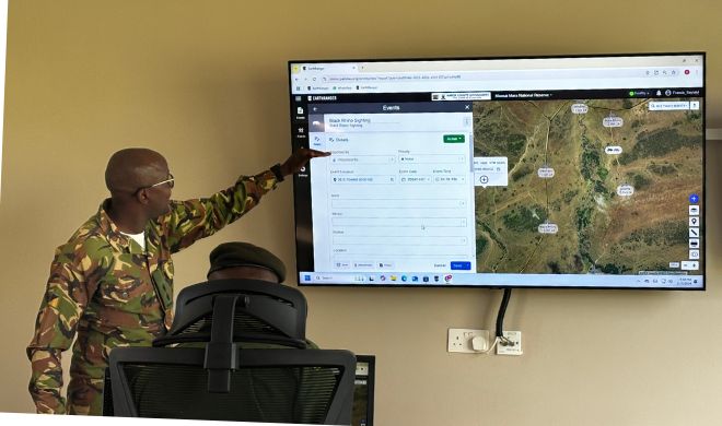
The scanners send real-time alerts to the anti-poaching control room. These alerts can also be shared with local communities or neighboring farms, enabling them to act as third-party partners in anti-poaching efforts. By involving locals directly in the response process, the system fosters collaboration, increases situational awareness, and empowers communities to take an active role in protecting wildlife.

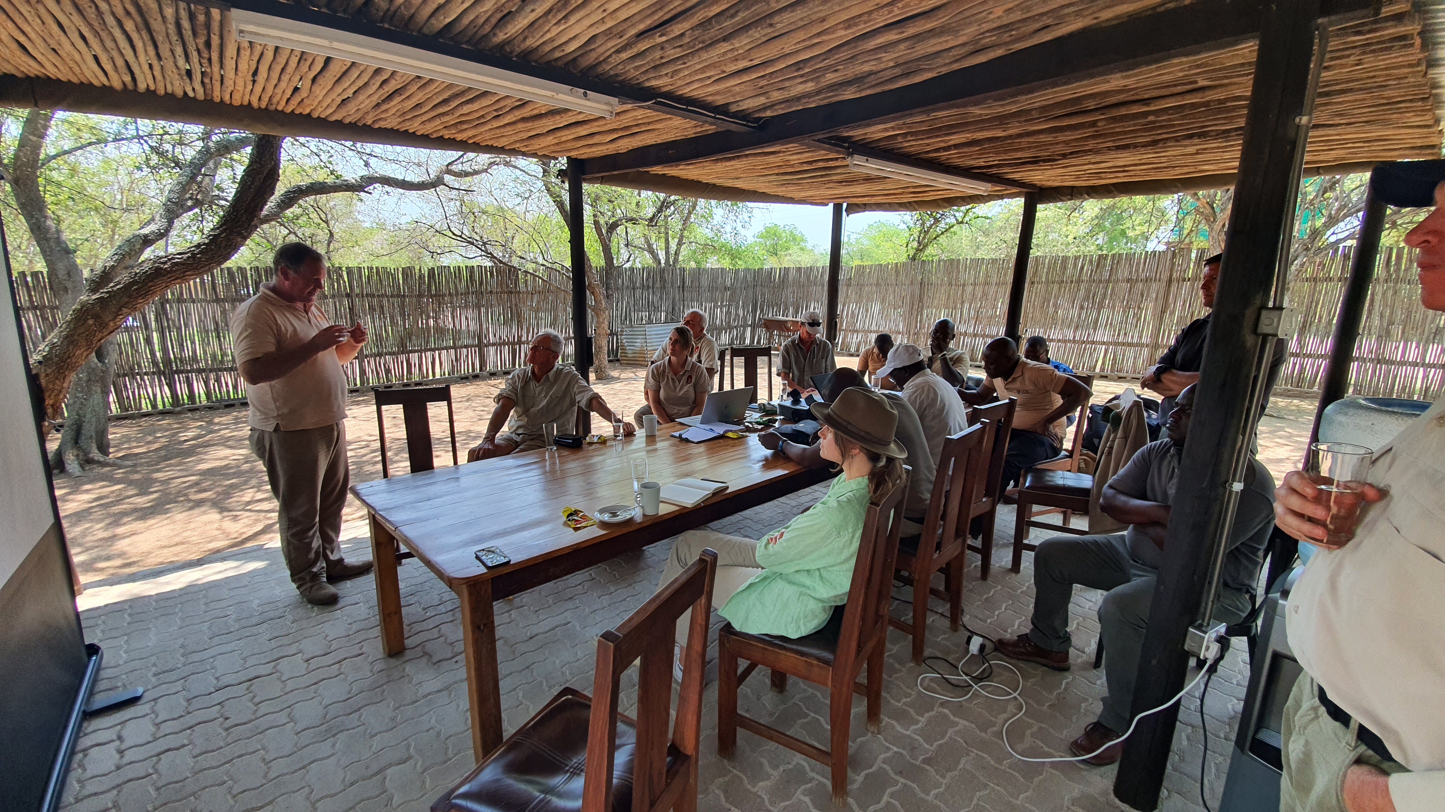
Scanneredge is a collaboration with Tech for Conservation organisation Smartparks, Management of national parks like Gonarezhou - Zimbabwe, park technicians, rangers(QRU) and the local community. Through this cross-sector partnership, we have demonstrated that ScannerEdge is ready for broader deployment, increasing the number of active national parks and total scanners in use.

To establish a successful cross-sector partnership, it is essential to clearly define each partner's role and level of involvement from the outset. Ensuring local ownership of the solution is crucial for achieving long-term sustainability and impact.

Purpose: To align resources, expertise, and strategic goals across different sectors for effective implementation and operational success.

How it Works: Partnerships are built through workshops, shared missions, and transparent agreements outlining roles and responsibilities. Regular evaluations ensure partnerships remain productive.

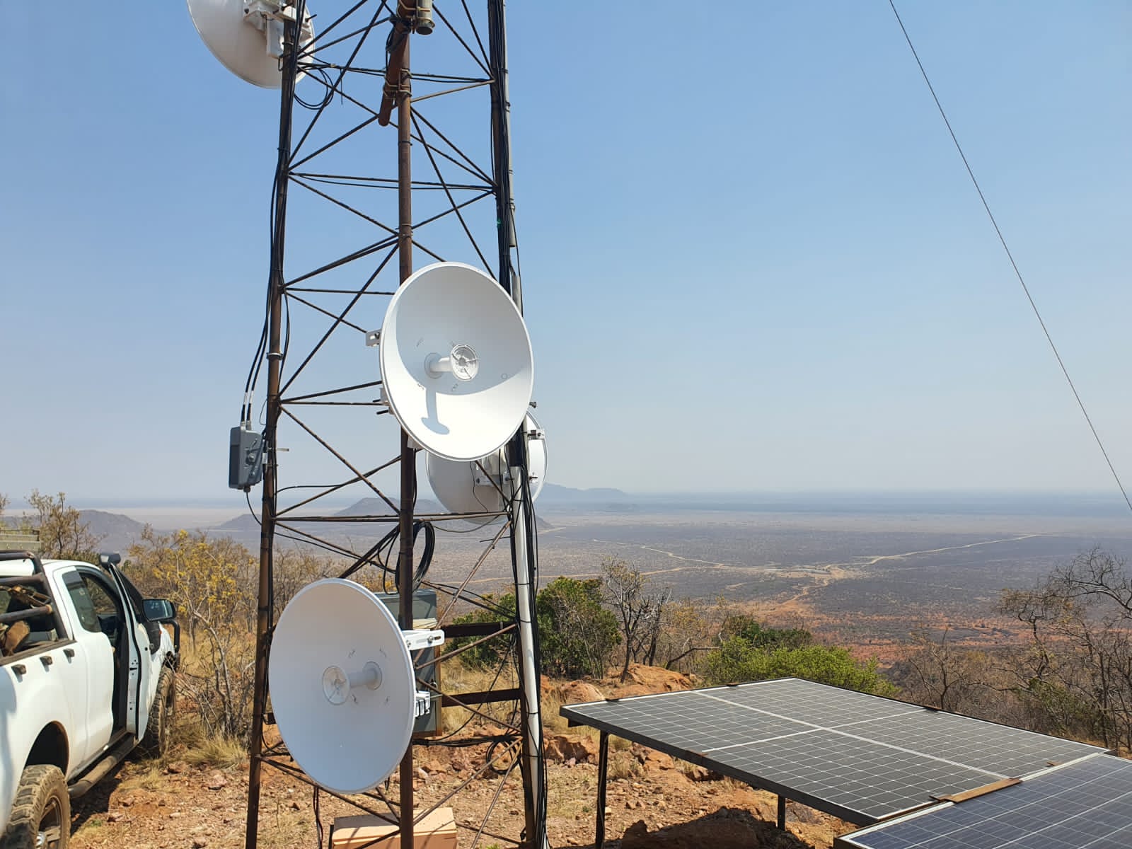
Scanneredge offers a plug&play innovation offering a quick installation that can be monitor the area for signs of potential poachers immediately after installation. 

The true success depends on the internal Rangers Quick Response Unit's ability to act swiftly and effectively on the real-time data provided. The unit must remain on constant standby, equipped with reliable transportation, and prepared to respond on poaching activity.

Building trust among stakeholders takes time but is essential for long-term collaboration.

Cross-sectoral partnerships increase funding opportunities and knowledge sharing, enhancing the overall impact.

Quick Response Unit acting on suspicious threats based on real-time data

Leveraging real-time alerts from ScannerEdge, a response unit can quickly assess and mitigate potential threats, such as poaching or other illegal activities.

Purpose: To translate RF signal detection into actionable insights that trigger swift response actions in the field.

How it Works: Alerts are routed to dedicated response teams equipped to investigate and intervene. ScannerEdge’s GPS functionality and integration into EarthRanger aids in pinpointing signal sources for precise action.

Response protocols must be clearly defined to avoid delays in decision-making.

Collaboration with local enforcement agencies enhances the effectiveness of rapid response teams.

Real-time response is more effective when combined with predictive analytics based on historical ScannerEdge data.

Mobile/Satellite Phone Monitoring

ScannerEdge specializes in monitoring RF signals from mobile and satellite phones, as well as other communication devices, to detect human activity in remote areas.

Purpose: To provide real-time intelligence on human presence or illegal activities by detecting and analyzing RF signals within a 3 km radius.

How it Works: ScannerEdge scans for RF signals (UMTS, Wi-Fi, Bluetooth, satellite phones, and VHF radios) and transmits alerts via LoRaWAN or satellite connectivity. Data is centralized for further analysis and decision-making.

ScannerEdge’s ability to integrate with multiple communication networks LoRa/Satellite ensures reliable data transmission even very remote regions.

Satellite data transmission, while robust, can be cost-prohibitive and requires funding models that accommodate operational expenses.

Proper calibration to filter false positives is critical for actionable intelligence.

Technical Installation and Training

Ensuring that ScannerEdge devices are properly installed and configured in the field, with thorough training for operators to maximize their effectiveness in detecting illegal human activities.

Purpose: To equip field teams with the skills and knowledge to install, operate, and maintain ScannerEdge devices, ensuring continuous functionality in diverse environments.

How it Works: ScannerEdge is installed in strategic locations, configured via Bluetooth through a smartphone app, and calibrated to local RF conditions. Training includes understanding signal detection, troubleshooting, and device maintenance.

On-site, hands-on training yields better outcomes than theoretical sessions alone.

Operators need to understand both the technical and practical implications of the data collected.

Regular follow-ups improve long-term device functionality and user confidence.

Connecting the public

Connecting the public: This mini program aims to promote the mainstream of biodiversity conservation by desensitizing current monitoring data in the industry and designing low threshold interactions for the traditional data labeling process. This allows the public to participate in the training process of biodiversity models in a more accessible and intuitive way through the mini program. On the one hand, the public can enjoy and learn about the most authentic protection monitoring images through the form of "playing games"; On the other hand, the power of the public can be utilized to continuously train a universal model of biodiversity, achieving the goal of citizen science in the process.
Through product design, 'Wild Friends' breaks down the process of annotating and verifying institutional data into tool based tasks, reducing the initial training costs of institutions. With simple guidance, volunteers or the general public can complete basic annotation content.
The first step is to check for the presence of animals (manually identified or judged by AI);
Step two, estimate the number of animals (manually determined);
Step three, select animals (manually or through AI evaluation of selection accuracy);
Step four, identify the name of the animal (manually selected or judged by AI);
Step five, randomly allocate cross validation in the background. Ensure the accuracy and consistency of data.
 

AI Species Recognition

AI species recognition: This product uses AI recognition as the underlying technology, with endangered species as the core recognition object. It trains a large biodiversity recognition model that can support monitoring of mountains, rivers, forests, fields, lakes, grasses, and sands systems. The model is free and open to public welfare organizations dedicated to biodiversity conservation, such as research institutes, conservation organizations, and individuals. The reason why "wild friends" are so powerful is because they have a powerful "engine": YOLO World.
As the underlying universal model of 'wild friends', its primary characteristic is strong learning ability. It has powerful multimodal zero sample recognition and few sample recognition capabilities, which means it can quickly identify animal location regions and species information of multiple species through a small number of samples. For example, to recognize a new species, traditional models require thousands of photos and several days of training; YOLO World only requires a small number of photos and training iterations to achieve rapid adaptation.
Secondly, it has a high degree of tolerance. No longer limited to training and prediction of specific species, it has strong open vocabulary recognition ability and zero sample recognition ability, and can accurately identify and locate untrained species. For example, traditional models can only recognize trained species such as tigers and antelopes; The new model can also recognize snow leopards and foxes simultaneously - even if it has never trained these two animals before.
Another advantage of "wild friends" is that they spend less money. Common AI models heavily rely on high-performance acceleration cards, which result in high costs for both hardware environment and maintenance operations.