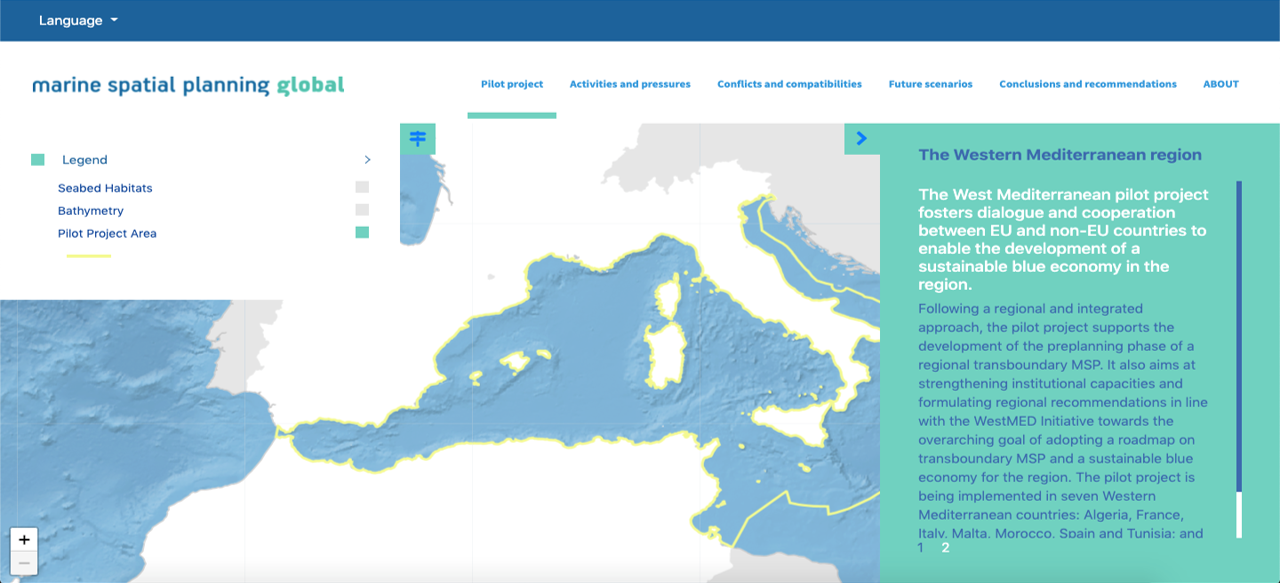
Showcasing key results through a simplified and interactive storytelling tool

This Building Block aimed to develop a multilingual storytelling tool to showcase both existing conditions and scenarios for the pilot in the Western Mediterranean. The objective was to present the data and information in a simplified and interactive way, and as such to turn complex concepts into notions easily understood by all stakeholders.

  • Professionals with previous experience in developing an online storytelling tool with spatial data visualization

  • Technical reports with the necessary data and information published in advance

  • Teamwork: Those involved in the development of the reports need to work in close collaboration with those responsible for developing the tool to ensure that the key results are properly selected and displayed

  • Structure: Organize the story through different themes, titles, taglines and sections

  • Be concise: Limit the size of the texts to the key messages. If the user is interested in learning more, reports with the full information should be available

  • Technical terms: Whenever possible, avoid using difficult and/or technical language (including acronyms) that might be incomprehensible for a wider audience. If it cannot be avoided, better to add the meaning

  • Responsive web tool: Depending on the type and format of the content, it might be difficult to ensure that the tool is sufficiently responsive across different internet browsers, resolutions and electronic devices

  • Beta version: It is recommended to develop a beta version (pre-release) and then ask some users to play with it before the launch

Showcasing key results through a simplified and interactive storytelling tool

This Building Block aimed to develop a multilingual storytelling tool to showcase both existing conditions and scenarios for the pilot in the Gulf of Guayaquil. The objective was to present the data and information in a simplified and interactive way, and as such to turn complex concepts into notions easily understood by all stakeholders.

  • Professionals with previous experience in developing an online storytelling tool with spatial data visualization
  • Technical reports with the necessary data and information published in advance
  • Spatial data organized in a geodatabase with metadata
  • Teamwork: Those involved in the development of the reports need to work in close collaboration with those responsible for developing the tool to ensure that the key results are properly selected and displayed
  • Structure: Organize the story through different themes, titles, taglines and sections
  • Be concise: Limit the size of the texts to the key messages. If the user is interested in learning more, reports with the full information should be available
  • Technical terms: Whenever possible, avoid using difficult and/or technical language (including acronyms) that might be incomprehensible for a wider audience. If it cannot be avoided, better to add the meaning
  • Responsive web tool: Depending on the type and format of the content, it might be difficult to ensure that the tool is sufficiently responsive across different internet browsers, resolutions and electronic devices
  • Beta version: It is recommended to develop a beta version (pre-release) and then ask some users to play with it before the launch
B2: Communication and capacity building strategy for climate action

The first step towards the development of a target group specific communication and capacity building strategy was a KAP analysis (knowledge, attitude, practices), which established a baseline, in terms of understanding the private sector´s knowledge about climate change, as well as its attitude towards the topic and the practices already in place. The analysis also included a capacity needs assessment, which served as input for ADAPTUR´s capacity building and training program. The findings were also used to train counterparts, consultants, and project members in better understanding the private sector and to improve their communication skills by using the right words, concepts and messages.


The training program comprised several topics about climate change vulnerability, climate-proof investment, cost-benefit analysis, national/subnational policies related to climate change, EbA solutions, public-private cooperation, financial mechanism, etc.


At the same time, a press campaign was launched in cooperation with local media and journalists. The ADAPTUR website was introduced with regular newsletters, best-practices, case studies and messages from industry leaders. It also contained a resources section with studies, tools and information material.
  • A good understanding of the industry context and the private sector´s challenges, priorities, needs and restrictions.
  • Create attention by linking climate change with business interests.
  • Recognition of private sector work culture and values (fast decision making, time is money, etc.). Offer cooperation and training formats that are suitable for the private sector.
  • Cooperation with industry leaders, known journalists and lead consultants as change agents to position the relevance of adaptation for the sector.
  • Plan some time for understanding your target group and awareness raising before you initiate the first direct contact. Preparing the ground and being well prepared may save you time later.
  • Work together with a professional agency to develop and implement your communication strategy.
  • Identify possible change agents in the private sector that could motivate other businessmen/women to engage in the project.
  • Encourage peer-to-peer dialogue and exchange between private sector actors to build a relationship, increase trust and learn from each other.
  • Offer planning and training formats that are suitable for the private sector context and consider local needs and realities (e.g. business executives normally do not have time to participate in day-long participatory workshops).
  • Recognize realities, limitations, concerns and existing risks for business leaders, entrepreneurs, and investors especially during pandemics like COVID-19 or other crises.
NaturaLista: citizen observations of biodiversity

Citizen science has influenced resource management, contributing to the improvement of public policies and strengthening the capacity of communities to address environmental problems. Also, citizen science efforts have contributed to conservation, the recording of biodiversity, and help empower communities by breaking down barriers that separate science and society.

Citizen science is being driven by technology and digital platforms, helping to collect and organize information and make it available to all. The NaturaLista initiative, for example, is a digital space for recording and organizing observations of nature through photographs, meeting other enthusiasts, and learning about the nature of Mexico and the world. Through this platform, awareness of biodiversity has been created in the communities and the exploration of local environments is promoted. Thus, fishermen and fisherwomen can contribute by recording species and being part of the change, keeping in touch with researchers and collaborating in different projects.

  1. Training the community in taking photographs, and in the use, management and scope of the digital platform.
  2. A greater impact is generated in the communities when the scientific information contained in the platforms is suitable for all audiences.
  3. It is key to integrate leaders and innovators of the coastal communities as users, so that they become examples to follow and more people join this initiative.
  1. The use of new platforms and digital tools can sometimes be a barrier for some members of coastal communities, so training and constant monitoring is required.
  2. Some communities have limited internet service. This can lead to disinterest in continuing to contribute to the platform, as a connection is needed for photographs to be uploaded to the platform.
  3. One way to motivate communities to use Naturalista is to provide feedback and follow up on the records they document through their photographs, sharing their use and the comments made by others. In some cases, the photographs have even identified new species and range extensions for Mexico and worldwide.
  4. Having photographic equipment suitable for use in the high seas is very important, since going out to sea every day can document incredible things.
Community-based climate change monitoring

Fishing communities are witnessing the effects of global changes every day. Aware that this impacts fishery resources and degrades marine ecosystems, fishing communities in Mexico have become interested in better understanding the effects of climate change and other local changes, giving them the opportunity to make better mitigation, prevention and adaptation decisions.

Through citizen science and collaboration with academics, a community monitoring program with oceanographic sensors has been implemented in 19 fishing communities in Mexico since 2011. Both women and men have been trained, involved and responsible for data collection and analysis. It has been proven that the training of mixed teams allows the integration of women in areas traditionally perceived as masculine (such as underwater activities), contributing to gender equality.

Today, fisherwomen and fishermen know how oceanographic sensors work, download the information collected, interpret the results and use them to make decisions related to the use of fishery resources, with a sustainable approach and seeking solutions to adapt to climate change.

  1. Multi-sectoral participation in climate change monitoring.
  2. Strengthening local capacities for community-based climate change monitoring.
  3. The exchange and analysis of information at the local and regional level.
  4. The relevance of oceanographic data and its interpretation for local decision making is evident to the community.
  5. The integration of mixed teams, since it favors performance and has a positive impact on the community.
  1. Training and community participation in climate change monitoring provides information to improve decision-making, mitigate the effects on fisheries, and adapt. Monitoring also provides tools to participate in discussion forums with the government, academia, civil society organizations, and the fishing sector itself.
  2. Just as participation is key, so is the systematization and rigor of data collection in conjunction with the fishing communities.
  3. Multisectoral participation allows better decisions to be made in terms of fishing and conservation, integrating traditional and scientific knowledge.
  4. The information obtained from oceanographic monitoring has empowered communities and given them a better understanding of the impacts of climate change. They have become an example of multi-sectoral partnerships, have participated in national and international conferences, and have inspired other communities and the government sector to replicate this effort.
Alliances

Various alliances had to be build to ensure the success of the programme. Collaboration was necessarry between the following stakeholders: 

  • Local and provincial government and administrative authorities
  • Social groups like youth clubs, women groups, agriculture committees
  • Forest and land protection committes 
  • Local, regional and national private sector businesses 
  • Various experts, researchers and scholars in this sector

Since this solution involves multi-level activities from planning, implementation, conservation, monitoring, marketing and promoting, it becomes essential to bring all the stakeholders together and interlink them through common goals and their ascribed responsibilities by the state and the society. 

- Stakeholders don't always have the same interests and goals

- Conflict between the stakeholders in the alliances are common because of their interests 

- The thoroughness of legal aspects while dealing with the local bureaucracy is needed

- The awareness of greater good has to be evoked to all the stake holders, time and again


Value chain logic

The scope of the Ocean Economy, considered in the Portuguese Ocean Satelite Account (OSA), aggregates activities in two main areas: "established activities" and "emerging activities” which, in turn, are divided into groups. It considers nine groups, eight of which correspond to established activities (groups 1 to 8). The last group (group 9) includes new uses and resources of the ocean, which congregates emerging activities (see figure). The adopted criterion for the classification of economic activities as established or emerging obeyed the international logic of maturity level of the markets, namely what is followed in the EU, in the study “Blue Growth” for the purpose of international comparisons.


Overall, we adopted a value chain logic considering, inter alia, the level of industry disaggregation permitted by the National Statistical System. Given this restriction, the methodological option was to consider Maritime and Marine Equipment Services as independent groups, including cross-economic activities in other groups.

  • Mature statistical systems with quality and detailed data
  • Broad discussion with several stakeholders on the concepts, definitions, and aggregations of the account
  • Very good articulation among entities
  • Time consuming activity in the first exercise due to its pioneering character (pilot exercise)
  • Difficulty in obtaining information on emerging activities
  • Results compensate the effort: this organization of data allowed illustrating heterogeneity of the different groups (dynamic, productivity, resilience, etc.)
Benefits generated to communities and livelihood improved

Community forestry in Nepal has brought a number of benefits including an increase in income. It has helped to fight against illegal logging by putting clear rules in place on timber access and a strong system of forest monitoring. Community livelihoods have also improved with easier access to firewood and fodder and better health care and energy access, for example through money from ecotourism and subsidies for renewable energy.

Community forestry shows traits of political, financial, and ecological sustainability, including emergence of a strong legal and regulatory framework, and robust civil society institutions and networks.

A continuing challenge is to ensure equitable distribution of benefits to women and marginalized groups.  


The immediate livelihood benefits derived by rural households bolster strong collective action wherein local communities actively and sustainably manage forest resources. Community forests also became the source of diversified investment capital and raw material for new market-oriented livelihoods. 


Communities empowered and trusted

Conservation oriented community forestry is essentially a participatory process that requires strong technical assistance on both policy and implementation. Expanding the property rights of local communities over resources and empowering them with knowledge, information, resources, technologies, and required skills for forest management and institution building are basic building blocks for the community forestry. Gender and equity concerns are addressed from the program design so that the poor, women, and marginalized receive fair benefits from the program.

Legal rights over the resources, institutions, capacity, trust, and leadership,

It evolved from the community level, and is based on traditional uses of the forest by communities. This bottom-up approach is a great strength of the Nepalese model as it gives ownership and leadership to communities to decide both where to create a community forest and how to run it.

Environmental Guide: Wildlife Friendly Roads

This guide is the tool used to collect wildlife data on roads to identify the impact and recommed measures for Costa Rica. It can be inpmenented on new road projects and for existing roads. Since 2015, this guide is used by Costa Rican Government to implement masures on new road projects. We started implementing it on exisitng roads since 2020. 

1. Government participation;

2. Funding for the data collection;

3. Legislation requesting measures to reduce development impact on wildlife;

4. Inclusion on the Environmental Impact Assesment;

5. Funding for the implementation of measures to prevent or reduce road impact;

In many countries of Mesoamerican region, guidance is needed to reduce road impact. So this document can be adapted to local characteristics and to legislation of the country to start the implementaiton of measures on roads for wildlife;