3. Management actions of the directorate to monitor and track the use of public sites.

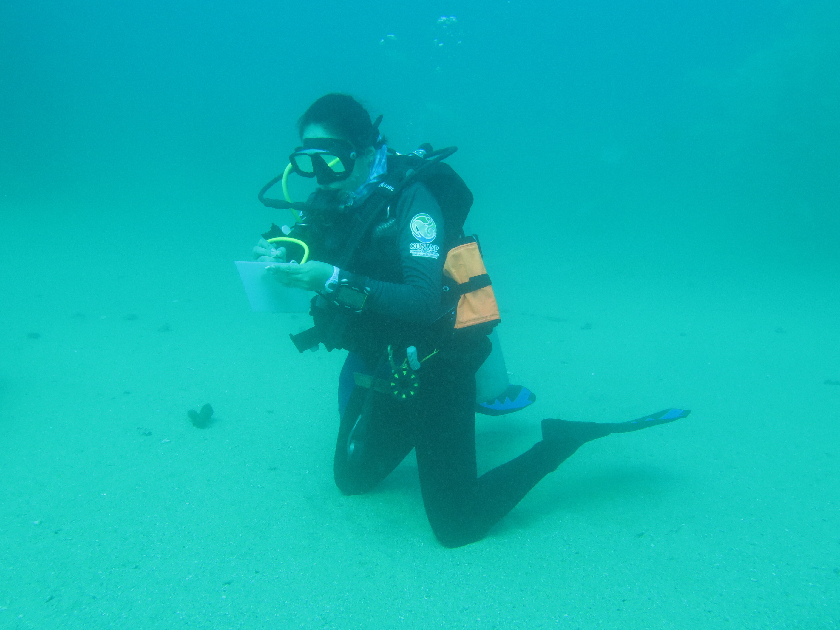
The rapid growth of tourism has caused negative impacts on reef ecosystems, caused mainly by inexperienced or careless divers. Damage has been observed since 2011. Later, in 2015 it was found that the sites of greater tourist use had more fragmented corals mainly of the genus Pocillopora. In 2016, CONANP and NIPARAJÁ participated in a workshop to exchange experiences on monitoring protocols of tourism use in Protected Natural Areas, where a standardized methodology was proposed to carry out impact monitoring and underwater monitoring. The impact assessment is carried out using the “Protocol for Monitoring Impacts and Surveillance of Snorkel and Autonomous Diving Activities for Marine Protected Areas” which has been used to know the impacts generated by recreational diving in sites with reef ecosystems, focusing on the number of contacts each diver makes on the substrate and the number of times corals are broken over time. Since 2017, the National Park personnel have been carrying out underwater monitoring and surveillance of diving groups. At each dive, a diver or tourist is selected and monitored for 10 minutes.

The presence of the management authorities of the National Park in the areas of public use allows the immediate detection of bad diving practices carried out both by tourists and their guides. This allows us to come into direct contact with them to explain the observed situation and thus be able to correct their performance.

Also, it is favorable that managers can monitor and supervise in real time the conditions of the reef and its elements.

It is important to mention that even though the managers of the protected area make every year a greater effort in underwater monitoring and the training courses on good diving practices have been maintained, the percentage of contacts by tourist divers on the environment has not reduced considerably. But a decrease in contact/impact on the reef structures has been detected.

It is extremely important to continue the underwater monitoring efforts in conjunction with the training of the guides to strengthen the management actions of the Cabo Pulmo National Park and the protection of the coral reef.

Working closely with the community

Working closely with the community respects the diversity of traditions, acknowledging elements of a backward nature.


The community work must begin with the interests and needs of the community itself; the work should act as the protagonist in the solution to problems.


The purpose of the governance processes that the Institute applies is to facilitate communication processes between the organization and the communities, using methodology based on inclusive management workshops.


  1. In the Brazil region, it is known that nature conservation is 90% related to local communities. Bearing this in mind, the Institute is building relationships and creating a long-term work plan.
  2. The bonds of trust that are established with the communities are crucial to being able to work closely with them.
  3. Government governance processes
  4. Governance processes in indigenous and community-based conservation areas.
  1. Several organizations have participated in initiatives in an effort to ensure conservation in and development of communities. However they have not been able to do so because they have not been able to understand and respect the communities.
  2. Various organizations still do not understand that 90% of conservation projects involve communities and indigenous peoples
  3. It is important to work hand in hand with government governance processes; effective management of the territory will be achieved by involving stakeholders.
Developed a complete Legal supervision,monitoring and patrol system

The Regulations on the Protection of Water Resources of Guizhou Province came into effect on January 1, 2017. It was the first, in China, to propose a full implementation of the “River Chief System” in local regulations, stipulating that the water resources (including lakes and reservoirs) management and conservation in the province shall be fully implemented the “River Chief System” at all levels government.

In addition, the administration has carried out a wide range of monitoring and analysis of water in the Huangguoshu Scenic Area Master Plan (2018-2035). For example, established a water quality monitoring and assessment system for cross-section boundaries, and provide ecological compensation if the water quality outside the boundary meets the assessment requirements. In addition, a strict patrol system was implemented. The local government requires district-level River Chiefs to patrol the river at least once a quarter, town-level River Chiefs to patrol the river at least once a month, and village-level River Chiefs to patrol at least once a week. The administrative departments of each district have to organize patrols at least twice a quarter.

  1. Govern water resources in accordance with the law.The decentralization of management functions and departments in the national water resources management and protection mechanism has led to multiple political inconsistencies and low efficiency. We rely on the law to support the River Chief's personal authority to effectively regulate the above-mentioned drawbacks.
  2. Established a reasonable and effective monitoring system.
  3. Recorded the operation of the monitoring equipment.
  4. Implemented the maintenance system of monitoring equipment.
  1. Adjust the relationship between "Govern by human" and "Govern by law": The "River Chief System" is a typical model of human governance. The effectiveness of water governance is closely related to individual authority, expertise, and experience. Therefore, it’s necessary to construct a legal system, and to coordinate the relationship between individual and law, to ensure the stability and continuity of the water governance, and to avoid the unfavorable situation of " Individuals leave, policies disappear".
  2.  Supervise with neighboring government departments: The agency should regularly carry out joint law enforcement with neighboring government departments.
  3.  Strengthen the supervision and voice of community residents: In addition to satisfying the public’s right to know, the agency needs to ensure the residents have a voice in the assessment and evaluation of the governance effectiveness as well as substantive supervision.
Authoritative Geodata and Map Services

The foundation of any SeaSketch project is geospatial information (maps) displayed as map services. There are no minimum data requirements. You can begin working with whatever you've got. Maps may be published as Esri REST Services (e.g., with ArcGIS Server or ArcGIS online) and open source mapping services (e.g., WMS, WMTS) and then imported into SeaSketch. Example maps include administrative boundaries (e.g., EEZ, territorial sea, existing MPAs), seafloor habitats, bathymetry, human uses, etc.


The maps you choose to include as Data Layers in SeaSketch depend on the goals of your process. If you are planning for marine protected areas, shipping lanes and aquaculture sites, you may want navigational charts, habitat maps, the distribution of fishing activities and other layers that may be used to guide users in the design of their plans. Protected areas are only meaningful if they effectively protect certain habitats, shipping lanes minimize collision and maximize efficiency, aquaculture sites are located in certain depth zones, etc. On a case-by-case basis, you will need to evaluate what data need to be viewed as maps, and what subset of these data need to be analysed.


In some cases, relevant map data may already be published as map services and discoverable in coastal atlases and other map portals. As long as they are in the correct formats (Esri map services, WMS, WMTS, etc), they may be imported directly into SeaSketch and displayed as map layers. 
 

In many cases, it will be advantageous to publish your own map services for display in SeaSketch. This will give you control over the cartography and performance of the maps.

Successful projects usually have a single GIS technician who is responsible for locating existing map services, acquiring data from providers (government agencies, NGOs, academics) and generating new map services using standard desktop and web-mapping tools. 
Partnership strengthens stakeholder linkages for Sustainable Growth

Partnerships with KMFRI and other relevant county departments have enabled the proposal development by the association to be review regularly and more effectively in order to submit a clear and non-ambiguous proposal to the World Bank and other funders. Handholding by partner agencies such as KMFRI, WWF, National Bank, Base Titanium, etc. has been essential in enhancing the knowledge on tendering, procurement of construction material, furniture and equipment.

  • Recognition that the project is addressing the need of the entire community.
  • Presence and participation of stakeholders from various sectors is providing effective technical knowledge and know how, as well as opening career opportunities for the youth.
  • Participation of community members in the activities of various stakeholders is creating job opportunities.


  • Appropriate timing for engagement of the local communities is crucial for success – the day, place and time of engagement must be agreeable to all otherwise the partnership will be skewed and might appear to be imposed.
  • Respecting and appreciating community culture and traditions is critical for smooth implementation of project activities e.g. ceasing to work during prayer time, or rescheduling to attend meetings (Known as Baraza) hosted by area Chief or Government representatives.
  • Culture of saving part of the income earned from daily activities is possible through discipline and good planning.
  • Antagonizing the community against fellow partner agencies should be avoided at all time.
  • All partner agencies working with the communities must stick to their roles and responsibilities at all time.
  • Sustainability of the community project is the most crucial aspect that will ensure the project doesn’t collapse once the champions exit or move on. New members must therefore be recruited constantly and trained on the ideals of the project through an internship programme.
Resources for decision making

A key component of the Soqotra Heritage Project is the ability to access information about the heritage of Soqotra to allow for decision-making. This was realized by incorporating all documented tangible and intangible heritage in the Soqotra Heritage Database implemented through the Arches Project. Although maintained externally, and although internet connections on Soqotra prevent access to such resources in any meaningful way, the local team have access to all information through the Arches Collector App which can be used to visualize information, and also to collect and add information in the field.

Updates can be verified and enabled at regular meetings at the Arab Regional Centre for World Heritage until a sustainable internet provision is enabled on Soqotra.

This has allowed stakeholders on Soqotra to access information for planning purposes, and to raise awareness with stakeholders about the importance of considering heritage components in development activities.

The building block required adequate provision and maintenance of the central database at a secure location as well as the ability to regularly update and access information.

Online solutions are not appropriate for Soqotra while the internet connections and availability is unsustainable and of low quality. This applies to ALL sustainable solutions on Soqotra and is not confined to heritage programmes.

Provision of an offline App is the first step, but requires routine updates that can only be accomplished at the expense of international travel and availability of flights.

Capacity building on financial management

Committee members were trained on book-keeping, basic audit process, budget planning and selection of tenders for constructions. Using partners such as the National Bank of Kenya (NBK) to train new committee members and regularly provide refresher courses for existing members has been essential to enable the Bank to grow more independently, save cost, and retain modern banking operations. Youth, especially local students, were involved to assist in drafting proposal writing and record keeping, applying what they learn at school.


The Association members were trained on writing and submitting applications for World Bank funding through HMP, which is critical for future funding or to obtain development loans. They also learned to develop their Strategic Plan 2018-2022. This strategic planning has enabled the Association to have clear focus of where they want to go. Although., there is need to start developing a new Strategic Plan for the next cycle, where partners including Base Titanium, relevant County Government department and NGOs operating in the area can be mobilised to assist in the process.

  • Capacity building and infrastructure support has been provided by partners.
  • The need to have a local bank nearby in order to reduce the cost of travelling long distance for banking.
  • Opportunity is being created for local students and youth to appreciate banking as a profession and to consider it as a career in the future.
  • Obtaining loans no longer require a laborious process with long distance travel to a major town such as Kwale or Mombasa.
  • The County Government can now channel funds more effectively and fast to the local Community Cased Organizations via KKCSA.
  • Training of Trainers - Use locally built capacity to train others and replicate projects in the neighbouring communities.
  • When trainers emerge from among the community following effective capacity building campaigns, they are appreciated locally and emulated easily.
  • Knowledge learnt in various aspects of financial management and banking opens up new career possibilities for the young, which were previously obscure such as book keeping, of foreign such as Information Communication Technology (ICT).
  • Locally nurtured capacity through training of trainers is more effective because the lessons can also be conducted in the local language.
Mobilizing Community Members through Local Leaders

Kinondo community recognised the need and importance of coalescing around a common vision in order to attain self reliance and improve their livelihood. They realised that while it is important to retain a strong leadership in the top management of the Bank, it is necessary to rotate members of the Committee regularly to enable members to introduce new ideas.  The opportunity is available for any capable individual to join the leadership committee. This is done democratically by holding regular elections. In order for the bank to thrive, Committee members are encouraged to create awareness and to encourage local people and those from the wider Msambweni Ward to join KKCSA to save and obtain loans and related services.

  • Community share common values in culture, faith and tradition, and they are also affected by similar challenges.
  • Goodwill from the community living in Msambweni Ward and its neighbourhood.
  • Community engagement and empowerment.
  • Bank covers multiple needs for all categories of the local people.
  • Limited inclusion and involvement of political sentiments.
  • Knowledge of the local languages, culture and tradition is crucial for implementing processes.
  • Delay in approval processes is caused by limited number of experts from relevant departments in the County and National government.
  • Inclusion of the community project in the annual County Integrated Development Plans (CIPD) contributes substantially in ensuring project sustainability.
Budj Bim Ranger Program

Budj Bim Ranger Programme is a key component of the institutional arrangements for the management and conservation of Budj Bim eco-cultural landscape. The programme is funded by the Australian government (through it’s Indigenous Protected Areas program) and managed through the Winda-Mara Aboriginal Corporation and employs full-time rangers mentored by Gunditjmara Elders to provide them with traditional and cultural knowledge and support. The Budj Bim Rangers are responsible for the management of the Budj Bim and Tyrendarra Protected Areas. The rangers are responsible for a wide range of management activities including native flora and fauna management, building and maintaining walking tracks, providing guided tours and monitoring.

The Budj Bim rangers have a key role in ensuring the cultural continuity and the ongoing transmission of traditional and contemporary Gunditjmara knowledge and practices across generations

The Indigenous Protected Areas program is funded through the Australian Government’s Indigenous Advancement Strategy program and the Budj Bim Ranger Program is implemented by the Gunditjmara in ways that support working on Country as a cultural activity that ensure transmission of knowledge and practice. Without the government funding, the Gunditjmara are not – at present – resourced to manage Country.

  • This management arrangement of Budj Bim Cultural Landscape allows on the ground management approaches to be guided by Gunditjmara Traditional Owners in line with cultural knowledge, traditions and practices.
  • Management and conservation activities conducted by Traditional Owners through the Budj Bim Ranger Programme has led to a high-degree of control and containment of environmental weeds and pest animals; and extensive revegetation of native plant species, including Eucalypt, Acacia, Bursaria and other native trees, shrubs, sedges, groundcovers, herbs and grasses.
  • The rangers are in charge of combating pest plants and animals; revegetation work using native plant species, many of cultural importance, is enhancing the natural and cultural environment.
  • Rangers play a key role in outreach and educational activities through the Visiting Schools Program. The Budj Bim Rangers run this program for school groups. Approximately 50 such visits take place each year (2017).
  • Land management and monitoring activities across the entire Budj Bim Cultural Landscape.
Legislation regulating protection and development

Previous to the inscription in the WH List, from 2000 to 2013, the HHTR World Heritage Administration and the Yuanyang Management Committee for World Heritage HHTR enacted a modern law and regulatory system to promote the sustainable development of the rice terraces based on local customary laws, such as regulations on forest protection and water resources use. They have drafted local laws, regulations and administrative measures. At the same time, they nominated the site to be protected at national level. They formulated conservation and management plans which were announced by the State Council and provincial people’s government so it could be incorporated into the national legal protection system. This would allow them to obtain State financial support. While using and maintaining the customary laws and village regulations, the conservation and management of the rice terraces are conducted according to the law and are gradually being integrated into the modern legal framework.

  • Modern management is integrated with community-based traditions through the setup of specialized conservation offices. These are complementary to the traditional social organization.
  • A clear understanding of the current state of conservation of the rice terraces and the management system through on-site research and work.
  • Issue of the Rules of Procedure and signing of the Target Responsibility which merged the traditional and modern conservation and law systems in China.
  • The enactment of laws and regulations is conducive to the long-term protection of the rice terraces. It is also the challenge and opportunity for the integration of traditional customary law in the minorities’ remote areas and the modern legal system under a new dual social structure combining traditional and modern management system, which exist in parallel at different levels and have not been integrated.
  • In the context of the new dual social structure, the traditional community-based organization comprising “Migu-Mopi” (persons in charge of religious affairs and artisans, ditch diggers and forest rangers) is inadequate for the increasingly complex and rapidly changing modern society, as well as  the maintenance and development of the rice terraces. There is an urgent need to integrate with  the modern administrative system and carry out an innovative management of the rice terraces.
  • Raising awareness of cultural laws and regulations needs to be undertaken among local communities. This could reduce difficulties and management costs, improving conservation efficiency.