Work in the nursery

The production of plant material in the PA for its own use facilitates the restoration process carried out within the area, since it is not easy to obtain these species in external nurseries. Taking into account this need, the SFFG nursery was inaugurated in 2021 and has a capacity to propagate and house more than 80,000 individuals of 23 species, including 13 species of frailejon, 3 of which are endemic.

The specific conditions for propagation, maintenance and species-specific production have been generated from the process developed with the protected area team. The propagation process begins with the collection of the seeds, in the case of the frailejones, these are found in the flower stalks, then they are sieved and the best ones are selected. They are then taken to the nursery for germination. The work in the nursery includes activities such as watering the seedlings twice a day, weeding, filling the bags, transplanting into the bags or potting, monitoring, experimentation and, of course, maintenance of the nursery.

-People working full time in the nursery.

-Experimentation and research aimed at optimizing germination processes and seedling care, as well as nursery maintenance.

-Strategic alliances for resource management and training.

Improved germination processes: storage and selection of seeds and technical pre-germination processes.

-Team with technical capacity and experience.

- In situ work allows for constant observation and experimentation in order to generate knowledge about the best way to propagate species for which no further information is available.

-Linking local knowledge and experiences learned in the construction of infrastructure.

- Seed storage and adequate collection times to increase viability.

Collaborative restoration of the páramo ecosystem

The release of areas within the Sanctuary that were used for cattle ranching, within the framework of the signing of conservation agreements with the farmers, to reduce pressure on the Paramo, was the first step in the recovery process of this important ecosystem, which offers vital ecosystem services for the territory such as water supply, water regulation, purification, carbon sequestration and habitat provision, besides being an area that is characterized as a corridor for various species of fauna, richness in flora diversity and presence of endemic species.

In this sense, this restoration initiative helps guarantee that local communities can continue to enjoy the benefits it offers and at the same time gain knowledge about the propagation and management of high mountain species.

Thus, the Sanctuary is committed to the conservation, restoration, and sustainable management of the ecosystem together with strategic allies such as regional environmental authorities, non-governmental organizations, local communities, public entities, and private enterprise.

- Local communities willing to participate in the actions proposed by the Sanctuary for the conservation of the páramo.

- Management capacity and sensitivity to socio-cultural aspects on the part of the Sanctuary's team to establish channels of dialogue and trust with institutional and community stakeholders.

- Working team with knowledge of páramo restoration.

-Integration of restoration actions to help prevent and mitigate use pressures.

- Research and monitoring information is key in the implementation of actions to prevent and mitigate pressures that impact strategic ecosystems such as the páramos.
Drone Data

Drones play a pivotal role in the 3LD-Monitoring system, complementing other data collection methods.Drones are essential tools in partner countries to fortify technical skills among local staff. These skills encompass flight planning, navigation and image evaluation. The drone monitoring aims to empower project staff to capture data tailored for photogrammetric analyses, from which crucial geoinformation emerges.

The drone mapping methodology encompasses five stages, with the first two focusing on drone operations:


  1. Mapping mission preparation (desktop work)
  2. Mapping mission execution (fieldwork)
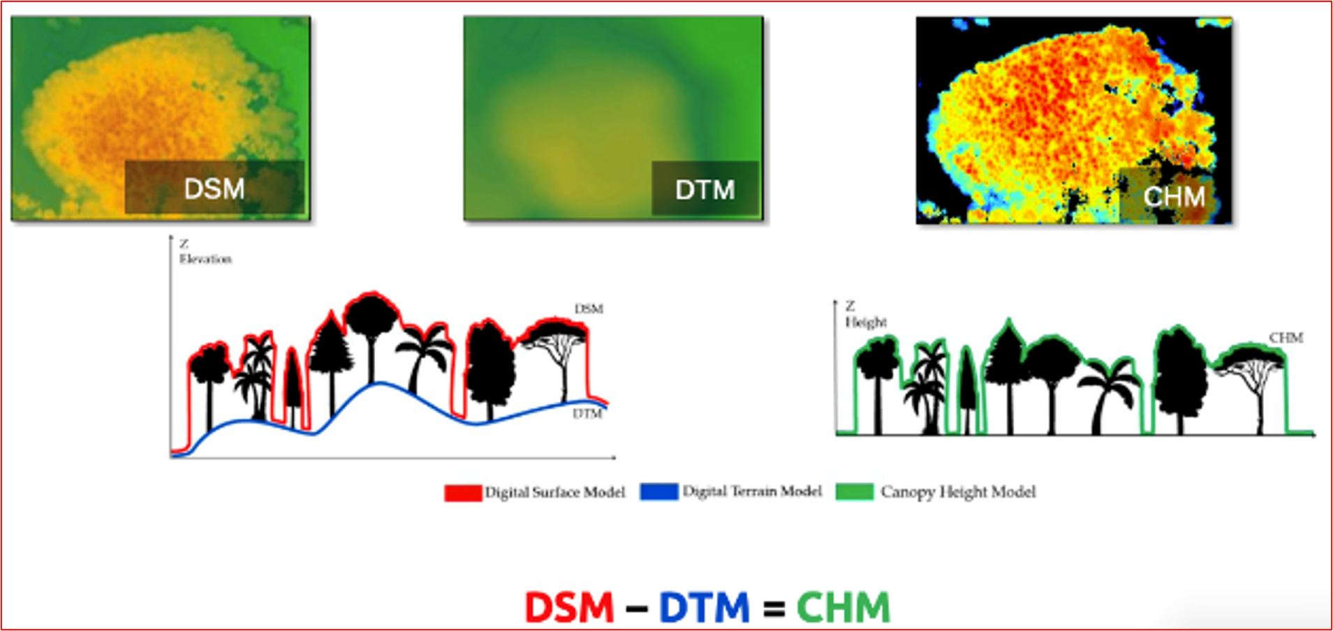
  3. Development of Digital Surface Model (DSM) & Orthomosaic generation (desktop work)
  4. Data analysis and refinement (desktop work)
  5. Integration into the prevailing data system (desktop work)


Drone data aids in evaluating indicators linked to carbon/biomass, such as mortality rates and forest types. Notably, with the application of allometric equations and proper characterization of the land type, above-ground biomass estimations of trees can be determined.

Drones with pre-set flight planning capability ensure seamless orthophoto creation from individual images. This enables individual snapshots to seamlessly merge into an orthophoto (aerial photograph corrected for distortions, allowing accurate measurements). It's also vital to consider the availability of these drones in the local markets of partner countries. Leveraging local knowledge by involving local academia is paramount in this process. They can provide essential allometric equations, grounded in tree height, that facilitate precise biomass calculations.

Drones generate high resolution images, allowing a detailed overview of land cover changes, tree survival and erosion rates, among others. Combined with field data, drone-based monitoring is strengthened, guaranteeing a sound monitoring.


The heterogeneity of trees and vegetation density often hinders a sound extraction of common key points between the images, which is necessary to estimate the heights and other indicators. In this regard, increasing the overlap between images to a minimum of 85 % frontal and side overlap can improve the extraction of key points. Also, increasing the flight height of the drone reduces perspective distortion, which facilitates the detection of visual similarities between overlapping images. However, too much overlapping, i.e., high overlapping percentages result in higher amount of data, making data processing more time intensive.


Another aspect already mentioned is the availability of suitable drones in the partner countries. Importing drones to the respective countries is difficult, and bureaucratic barriers persist.

Satellite Data

Satellite data forms the bedrock of the 3LD-Monitoring system, harnessing the capabilities of open-source imagery from the Copernicus Sentinel-2 and LANDSAT satellites. An algorithm, meticulously developed by Remote Sensing Solutions (RSS) GmbH, revolutionizes this process. Users can seamlessly submit the shapefile of their area of interest, prompting the algorithm to automatically fetch and analyze relevant data. A spectrum of robust analyses are conducted including the 5-year vegetation trend using NDVI for assessing vegetation gains or losses, 5-year vegetation moisture analysis through NDWI, and a nuanced 5-year rainfall trend evaluation. Additionally, the algorithm facilitates the visualization of vegetation changes since the inception of the project, bolstering the monitoring framework with dynamic insights. Satellite data, a vital component of the 3LDM-Monitoring system, leverages open-source imagery from the Copernicus Sentinel-2 mission and LANDSAT satellites. For predefined areas, this data is automatically fetched and analyzed for specific parameters. Key analyses include a 5-year vegetation trend using NDVI as a proxy for vegetation gains or losses, a 5-year vegetation moisture trend through NDWI, and a 5-year rainfall trend. In addition vegetation changes from project start can be visualized.

Effective use of this building block hinges on users drawing and saving areas in GIS platforms like QGIS. Additionally, enhancing the shapefile with project specifics, such as start dates and FLR type, optimizes analysis. Proper training in these skills ensures accurate data input and tailored monitoring, making capacity building in these areas essential if not present.

While satellite data, especially open-source, offers broad insights, its capability for species identification is highly restricted, if not unattainable. This limitation emphasizes the indispensable role of field work in discerning species composition and characteristics. Additionally, understanding the innate constraints of satellite imagery, especially with young tree plantations, reinforces the need for integrating field and drone data to gain a comprehensive view of forest terrains.

Field Data

Satellite and drone images, despite their undeniable contribution for monitoring, they are limited in the initial years of FLR efforts. Data collection at field level is crucial in the first projects years.


Data collection at field level is further divided into three participative approaches:


  • Permanent sampling plots: Fixed plots, where tree height, DBH, and tree survival rates will be estimated. Permanent sampling plots will be assessed in 3-year interval, due to their high labor and time input.
  • Land use planning: discussion rounds for the assessment of information, as well as identification of endangered species according to the Red List of Threatened Species by the World Conservation Union (IUCN). It is integrated into other land use planning processes, and thus, has not a defined assessment interval.
  • Transects: Identification of floristic and faunistic species, as well as forest structure composition, in an assessment interval of three months

All relevant indicators included in the three participative approaches are collected using the KOBO Toolbox. This software offers suitable conditions and is easy to operate, aligning with the monitoring objectives of the project.

A participative approach is essential in guaranteeing a long-term monitoring of the restored areas. The symbiosis of local knowledge and training/capacity building of local staff and regional partners is the core of this approach. Identifying the needs of the community, organizing discussion rounds, involving the local community in the developing and testing of the monitoring system, encourages consciousness and connection to the restored landscape.

  • Field Data Priority: In early FLR stages, field-level data collection is more effective than relying solely on satellite and drone images.

  • Participative Approaches: Employing participative methods like permanent sampling plots, land use planning, and transects involves local communities and enhances monitoring.

  • Appropriate Technology: Using user-friendly tools like KOBO Toolbox aligns well with project objectives and simplifies data collection.

  • Local Community Engagement: Engaging and training local communities ensures long-term success and fosters a connection to the restored landscapes.

Assessing and strengthening institutional capacity for mainstreaming landscape restoration in sectoral plans

To ensure landscape restoration is adequately mainstreamed in sectoral and local action plans, TRI Tanzania undertook an assessment on institutional capacity for mainstreaming restoration in institutions with mandates related to SLR. The undertaking aims at identifying key capacity gaps and generating recommendations for enhancing institutional capacity for mainstreaming landscape restoration in the target plans. Target sectors are those with mandates relevant to SLR such as agriculture, livestock, land, water and mining. On enabling Ministerial mandates and operational arrangements, the assessment revealed low levels of staffing and competence on SLR. In terms of supportive policy and legal instruments, existing sectoral policies and strategies need to be reviewed and updated to accommodate emerging environmental global issues and ambitions. Cross-sectoral coordination structures exist, most of which are passive with limited capacities to coordinate SLR. Identified gaps and recommendations will inform the design and implementation of capacity building modules and programmes to enhance restoration integration in cross sectoral plans. Continuous strengthening of institutional capacity is a critical step towards supporting environmental restoration and biodiversity conservation in Tanzania.

TRI was able to build institutional capacity for mainstreaming SLR because of the expertise the project gathered. Other major factors are interest and willingness of target Ministries and Local Government authorities in participating in the assessment. The effectiveness of the capacity building programme depends on the extent that it reflects and addresses stakeholder issues. Critically, the participatory ROAM assessment informed the National Environmental Masterplan formulation process and ensured the right areas were prioritized in recommendations.

The existence of conservation regulatory frameworks alone is insufficient to advance and sustain restoration objectives in the face of competing sectoral priorities and land uses. A critical process is integration of restoration in sectoral and local action plans. Mainstreaming is critical for minimizing negative impacts of regulatory frameworks on SLR and maximizing synergies between restoration and development objectives. By undertaking assessment and delivering tailored trainings, TRI Tanzania has learned how to strengthen institutional capacity for mainstreaming SLR in sectoral and local plans. Institutional capacity for mainstreaming SLR comprises of both in-house technical capacity and adequacy of regulatory frameworks. Identification and assessment of the relevancy and strength of existing frameworks defines the nature of impact of such frameworks on SLR.

Establishing Cross Sectoral Planning Mechanisms for Sustainable Land Restoration

To help incorporate cross sectoral planning mechanisms and frameworks, TRI Tanzania has worked to establish and support a cross-sectoral national working groups (a national SLR committee) with a core mandate to promote sector integration as well as guide and coordinate the implementation of SLR programs. This aims to ensure Tanzania achieves its AFR100 / Bonn Challenge Restoration target. Further, TRI has initiated the establishment of landscape level multi-stakeholder platforms to address competing and conflicting land use interests towards a shared vision. Cross-sectoral planning mechanisms are expected to address silos in planning, decision making and implementation of SLR initiatives to enhance biodiversity conservation, climate resilience and local livelihoods. Stakeholder engagement and participation is provided for in different policy frameworks defining the position as well as the specific roles and responsibilities of the various stakeholders and sectors. By addressing multi-sector issues and including diverse stakeholders, TRI was able to incorporate cross sectoral planning mechanisms in SLR policies that also address cross-cutting issues such as good governance, resource mobilization, and gender.

The cross-sectoral mechanisms would not have been successfully established and functional without interest and willingness amongst stakeholders. Shared challenges, desire for a common vision and clearly defined priorities catalyzed the need for concerted efforts and effective communication, engagement and coordination ensured effective stakeholder participation in SLR working groups. The mechanisms provide opportunities for addressing and capitalizing on conflicting priorities and synergies, leading to win-win conservation and socio-economic outcomes.

By working to incorporate cross sectoral planning mechanisms and contribute to policy processes that use multi-sector and multi-stakeholder participation to address cross-cutting environmental issues, TRI Tanzania learned what interests and priorities each of the different sectors have and how restoration can be influenced and implemented by these sectors. Additionally, with the use of the cross-sectoral working group to guide and coordinate SLR work, TRI learned how the various agencies and stakeholders work together to negotiate,  formulate policy and mainstream restoration work. The process allows TRI to identify where relationships, alliances and partnerships can be established and strengthened, which synergies can be leveraged, and how the different stakeholders approach restoration policy process and implementation. All these lessons taught TRI how to best to design and operationalize cross-sectoral mechanisms that integrate sectoral interests and priorities and a range of cross-cutting issues.

Reviewing Relevant National Policies: Identifying Gaps and Generating Recommendations

TRI Tanzania collected baseline data in the areas of policy, development plans, and legal frameworks that impact SLR initiatives and evaluated the extent to which they supported SLR, including community and private sector participation in restoration. This process resulted in the identification of policy gaps and in generating key recommendations for enhancing regulatory enabling environment for SLR. The proposed high-level and intervention level policy recommendations is expected to result into the reformulation of regulatory frameworks at national and local level. In addition, the Project conducted a environmental and social safeguards study  in the seven districts implementing the project to map potential environmental and social risks. The safeguards report informed the design of the Environmental and Social Management Plan detailing key measures  and  strategies for  minimizing key risks and negative impacts that may arise during the project’s implementation..   This robust review allowed TRI to push priority interventions in its policy development work and ensure any negative impacts are mitigated.  

The review of national policies and the identification of existing gaps in restoration and generation of concrete recommendations was made possible through the technical input through TRI Tanzania experts and partners. Further, this was enabled by stakeholder interest and willingness underpinned by shared vision and strategic priorities. In addition, effective stakeholder engagement and coordination further ensured successful policy review.

By reviewing existing restoration related policies, legislations and plans, TRI Tanzania  has learned lessons around where restoration policy and legal frameworks need to be strengthened and which existing actions have been successful in facilitating restoration. Reviewing the existing frameworks also provides information on where the expertise from the different agencies and stakeholders can be used to better improve restoration policies and more efficiently implement them. Additionally, TRI Tanzania initiated to identify the environmental and social safeguards, the project learned what strategies and measures needed to be established to minimize the negative impacts that might happen due to the activities undertaken by the project on the ground. Through its thorough policy review and identification of safeguards,   TRI Tanzania learned what policy gaps needed to be addressed to enhance regulatory frameworks that are supportive of SLR as well as suite of strategies for safeguarding the environment and local communities.

Developing a Policy Framework for the Sustainable Commercialization of Non-Timber Forest Products and Services

TRI’s Kenya ASAL team has also supported the development of a policy framework for the management and utilization of NTFPs. The First National Strategy and action plan for Sustainable Commercialization of Non-Timber Forest Products and Services in Kenya has been developed to support sustainable production, extraction, utilization, access to finance and market development of NTFPs and Services value chains in Kenya. A multi-stakeholder consultative approach through a Technical Working Group (TWG) that includes TRI's National Project Coordinator (a renowned NTFPs specialist), held an inception meeting and developed the structure for the strategy and action plan which KEFRI used to develop an initial draft. A number of meetings were held  to review and improve the draft strategy and action plan before subjecting it to public participation in seven clusters throughout the country. Additionally, TRI has helped the government develop their 2016 forest regulation on equitable benefit the Forest Conservation and Management Act, sharing with sensitization workshops and recommendations to ensure NTFP benefits are properly distributed. 

The development of the NTFPs Strategy was enabled by the robust literature review, surveys, and consultations undertaken by KEFRI. Without the review and situational analyses, the strategy would have missed appropriate intervention measures, stakeholder needs, and the contours of the various NTFP subsectors. TRI would also not have been able to pursue measures related to the equitable benefit sharing in forestry without the pursual of policy by the national government.

By supporting the elaboration of the NTFPs Strategy, TRI gained critical information about how generating science-based information along with consultations helps develop more robust policies. As the team helped identify 14 NTFPs, including seed oils, indigenous fruits, medicinal plants aloes, dyes and tannins, and ecotourism, as well as potential government interventions the government, TRI worked to highlight science-based information and how it could be used in restoration. The process of consultations also underscored key potential interventions included in the strategy such as the establishment of local tree nurseries and the branding and certification of medicinal plants. By working to promote and develop the regulation on equitable benefit sharing, TRI was able to learn more about how to communicate with local communities and how equitable benefit sharing could most effectively be pursued in the forestry sector. In all, TRI Kenya ASAL learned that joining science-based knowledge with input from local communities allows for policies that address local issues with evidence-based measures.

Facilitating the Integration of Natural Resource Management and FLR Policies at the County and Local Levels

TRI has worked to integrate natural resource management and FLR policies at the county and local levels by facilitating the elaboration of multiple county policies. This includes the creation of a policy influence plan (PIP) to mainstream FOLAREP within county units and enable effective integrated restoration that targets multiple benefits for both people and the environment. TRI also provided technical input and logistical support for the creation of three County Environment Action Plans in Marsabit, Isiolo, and Laikipia counties. The final action plans have been drafted with validation workshops to take place now that recent elections have concluded. Once validated, the plans will go through the county assembly where they can be approved and actualized. These policies will facilitate the implementation of FOLAREP and further promote FLR with greater local context in the three counties. Furthermore,  Isiolo County has developed a County Climate Change Policy and a County Rangeland management bill that both await approval. Additionally, the county produced a County Prosopis species management plan that has been operationalised.

To be able to elaborate these county policies, TRI benefited from a willingness from county officials to implement policies that included FLR and sustainable natural resource management measures as well as the enthusiastic participation of local leaders in the consultations and workshops needed to draft the action plans. Without the political will to pursue FLR policies, the action plans would not have been able to be drafted. 

Throughout the process of creating the various county policies, TRI was able to learn lessons around how county policies and regulatory frameworks can be better suited to effectively integrate FLR in natural resource management and implement national FLR policies. The process also provided a road-map on how to elaborate and adopt policies at the county level. By working to develop the county action plans, TRI now knows better how to successfully enact future policies further promoting FLR and sustainable natural resource management.