Localized Reference Library Development

The creation of a comprehensive, open-access DNA reference library of native plant and animal species was foundational to our solution. Recognizing that global databases lacked coverage for many Eastern Mediterranean species, we built the first Lebanese library encompassing plants, mammals, and now expanding to insects, birds, and fungi. This reference database improves the accuracy of DNA sequence matching and enables precise identification of species present in environmental samples. It also fills a critical regional data gap and facilitates ecological studies, biodiversity monitoring, and conservation planning. By publishing the library openly, we promote transparency, collaboration, and the potential for adaptation in similar biodiversity hotspots.

Strong institutional support from Saint Joseph University, collaboration with local taxonomists, and access to specimens were vital. Funding from initial grants allowed sequencing efforts. Commitment to open data principles ensured broad accessibility. Support from iBOL facilitated integration into global databases, enhancing utility and visibility.

Building a reliable reference library requires significant coordination between molecular scientists and taxonomists. Accurate species identification depends heavily on quality-verified voucher specimens and metadata. The process is time-consuming but indispensable for meaningful metabarcoding results. Sharing the library openly generated interest and collaboration but also highlighted the need for continuous updates and expansion to cover more taxa. Engaging local experts fostered ownership and increased the scientific credibility of the data, ensuring the library’s sustainability as a national resource.

Advanced DNA Barcoding and Metabarcoding Techniques:

DNA barcoding and metabarcoding are cutting-edge molecular techniques that allow precise identification of species from small biological samples such as animal scats. Barcoding targets a single species by sequencing a standard gene region, while metabarcoding amplifies multiple DNA markers simultaneously, enabling comprehensive analysis of complex mixtures. These methods provide detailed insights into animal diets, predator-prey relationships, and seed dispersal patterns without invasive sampling. In our solution, these techniques were adapted to the Lebanese ecological context, enabling high-throughput biodiversity assessment and revealing key interactions between fauna and flora. This approach overcomes limitations of traditional ecological surveys and opens new possibilities for monitoring biodiversity changes, especially in regions with scarce baseline data.

Access to high-throughput sequencing technology, expertise in molecular biology, and the availability of regional reference libraries enabled successful implementation. The collaboration with international experts, such as the Smithsonian Institution, ensured methodological rigor. The development of protocols tailored to local conditions and sample types was crucial for reliable results. Funding from FERI and MEPI provided the necessary resources to establish and scale the molecular workflows.

We learned that customizing DNA metabarcoding protocols to local ecological conditions is essential to maximize data accuracy. Establishing comprehensive reference libraries beforehand is critical for correct species identification. Early engagement with molecular experts and international partners accelerated technology transfer and improved quality control. We also discovered that noninvasive sampling methods, such as scat collection, can yield rich data but require strict protocols to avoid contamination. Finally, integrating these molecular tools with traditional ecological knowledge strengthens interpretation and practical application for restoration.

Foundation - Consultation with stakeholders, identify and prioritize suitable device, platform and network to be applied at MPNR for efficient wetland monitoring

Goal: To lay the foundation for integrating I&T solutions into traditional wetland management

Objectives: 

 - To introduce three proposed IoT applications to wetland stakeholders and I&T sectors 

 - To consult wetland stakeholders and I&T sectors for their views and comments 

 - To review potential IoT applications beneficial to the management of MPNR 

 - To identify and integrating relevant IoT solutions for gei wai operation and wetland research into MPNR  


Studies were conducted to identify and prioritize suitable device, platform and network to be applied at MPNR for efficient wetland monitoring by:  

Consultation with wetland stakeholders:

  • Consultation with Mai Po Management Committee (MPMC), which comprises of representatives from Agriculture, Fisheries and Conservation Department, Hong Kong Bird Watching Society, academics, independent wetlands experts and ornithologists.  Obtained advice on the proposed IoT application. 
  • Consultation with local village communities. Their input helped align the project with community values and needs.
  • Consultation with innovation and technology sectors. Technical advice obtained on the selection of proposed IoT applications, transmission network system and deployment requirements from Electrical and Mechanical Services Department, Innovation and Technology Commission, member company of Incu-Tech Programme, Hong Kong Science & Technology Park.  

Review of potential IoT applications in wetland conservation:

  • A Technical Review Summary of Potential IoT Application was created (as attached)

Views and suggestions from MPMC are summarized as follows: 

  • Given that I&T solutions could be expensive, compromise between data sampling frequency and cost has to be made
  • Selection of locations for sensors deployment provides detailed information for habitat management
  • Quality control of data is crucial 
  • The real-time, automated IoT monitoring system enhances efficiency of data collection. The data can correlate with other scientific researches
  • Deployment of sensors might visually affect the natural landscape of wetlands

Views and suggestions from I&T sector are summarized as follows:

  • The proposed three applications are feasible 
  • Scope of service has to be clearly defined. This might include a execution plan, application implementation service, technology consultation service, vendor management service, on-site installation, platform establishment, data analytic service, maintenance service 
  • The platform should be able to capture data, establish data pipeline and integration and perform data analysis 
  • Functional requirement for the platform such as user access, building information model (BIM), alert, data streaming and dashboard analytics should be clearly stated
  • Technical requirements for the platform such as computer specification for operating the platform, BIM format and capacity, data security should be clearly stated 


Deployment - Partnership with local Government Department - Electrical and Mechanical Services Department (EMSD) for the utilization of Government-Wide IoT Network (GWIN)

Partnership with EMSD allows us to utilize GWIN network as a transmission layer for all sensors installed for this project at Mai Po Nature Reserve (MPNR) with no network recurring cost required.

The technology offers several benefits that make it well-suited for wireless data transmission in IoT applications. Its long-range capabilities allow data to be transmitted over a distance, making it ideal for vast rural areas like MPNR. Furthermore, LoRa’s efficient power consumption extends the battery life of battery-powered devices. LoRa data transmission also ensures the confidentiality and integrity of the data through secure protocols.

In this project, four GWIN LoRa gateways were installed by EMSD within Mai Po Nature Reserve (MPNR). The sensors installed at MPNR are connected to gateways via the low-power and private LoRa network and eventually connected back to the GWIN backend via the 4G network. Besides these four gateways specially installed for this project, other GWIN gateways near MPNR can further secure data transmission reliability. 

In return, these four gateways can also help receiving signal from the sensors installed by various government departments in the surrounding area. 

Traditional sensors would each require a 4G connection to connect to central servers. In the GWIN network, sensors are connected to gateways via the low power and private LoRa (Long Range) network. The network with low power consumption reduces the cost and complexity of installing the sensors and improves the security of the system and data without the need of using a third-party network.


Pursuing strong partnership with EMSD allows us to more efficiently tackle challenges we are facing at MPNR (limited access to internet and city power) through their well-established network and support. 

Building Block 1 Field Research & User Insights: Understanding Menstrual Product Access and Preferences in Nepal

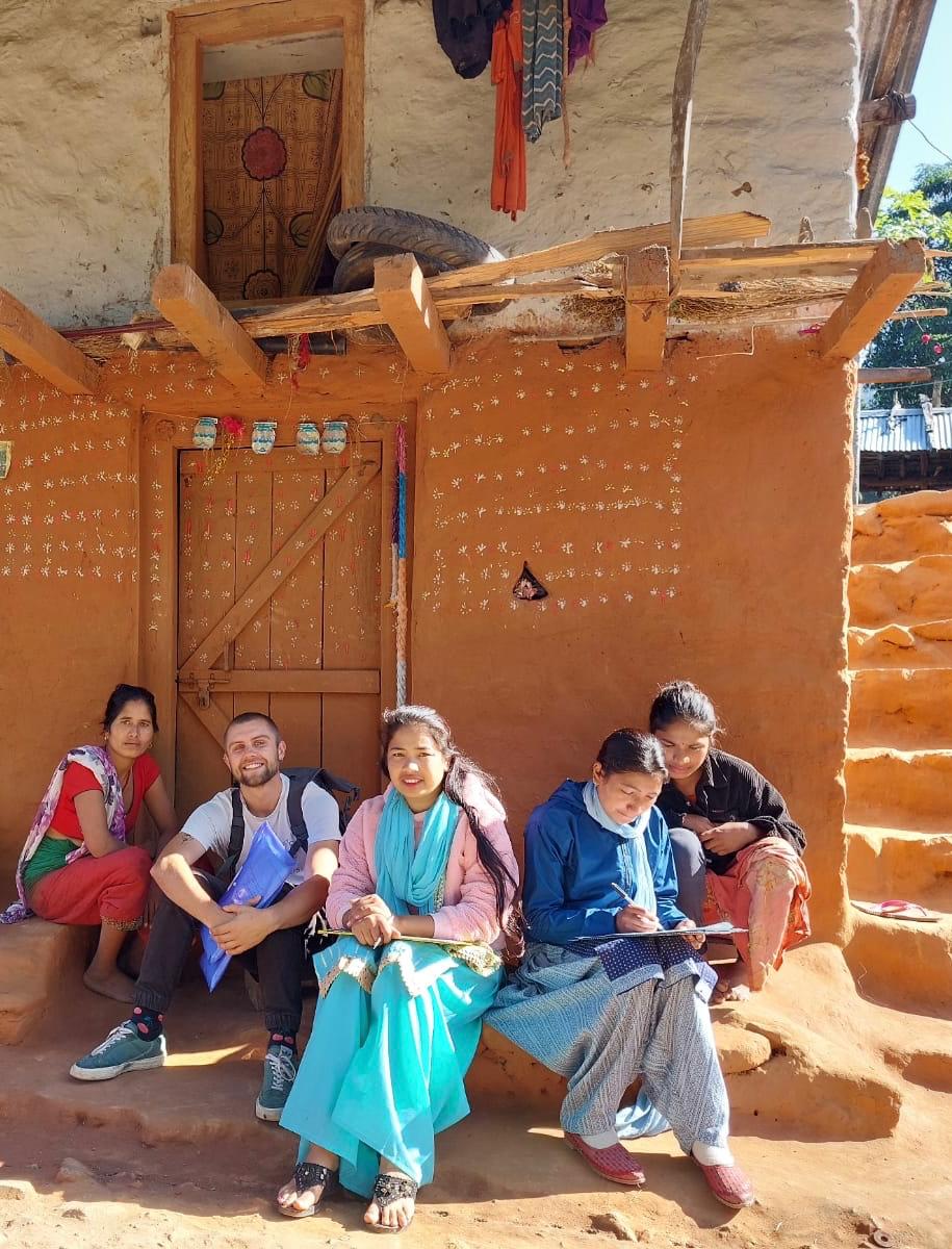
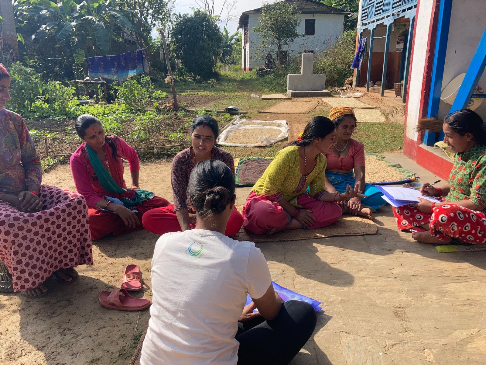
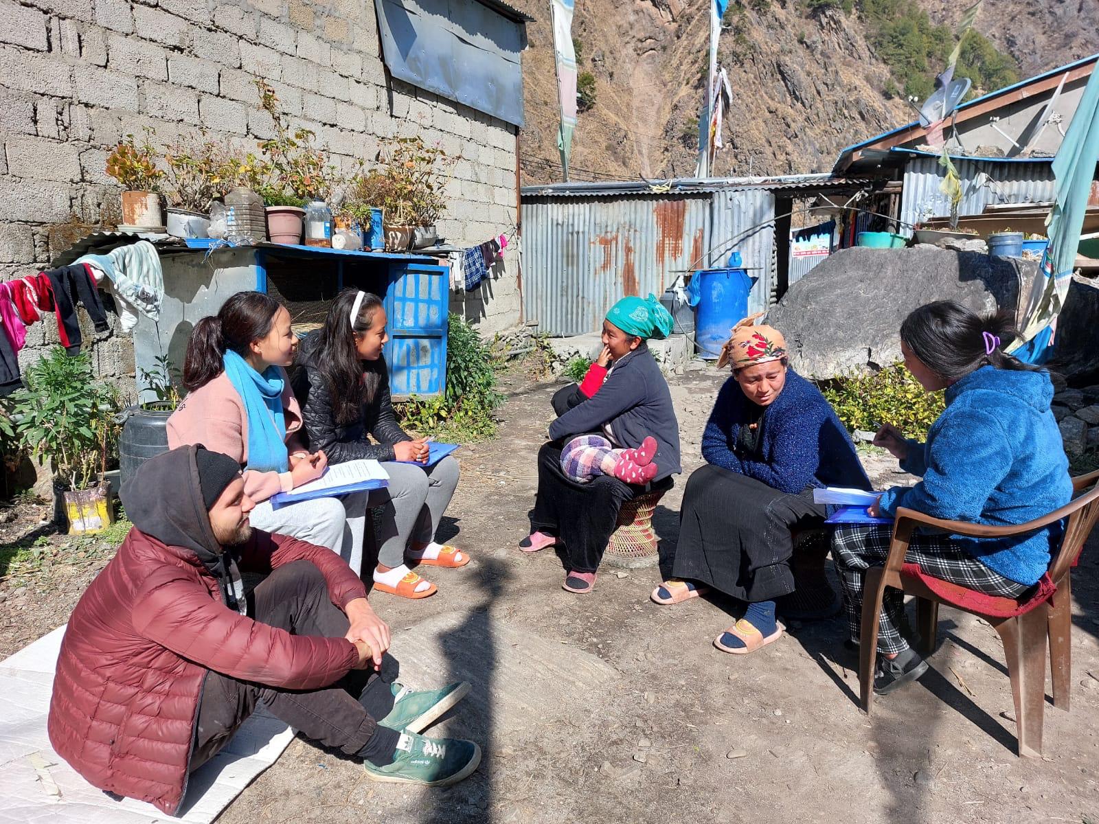
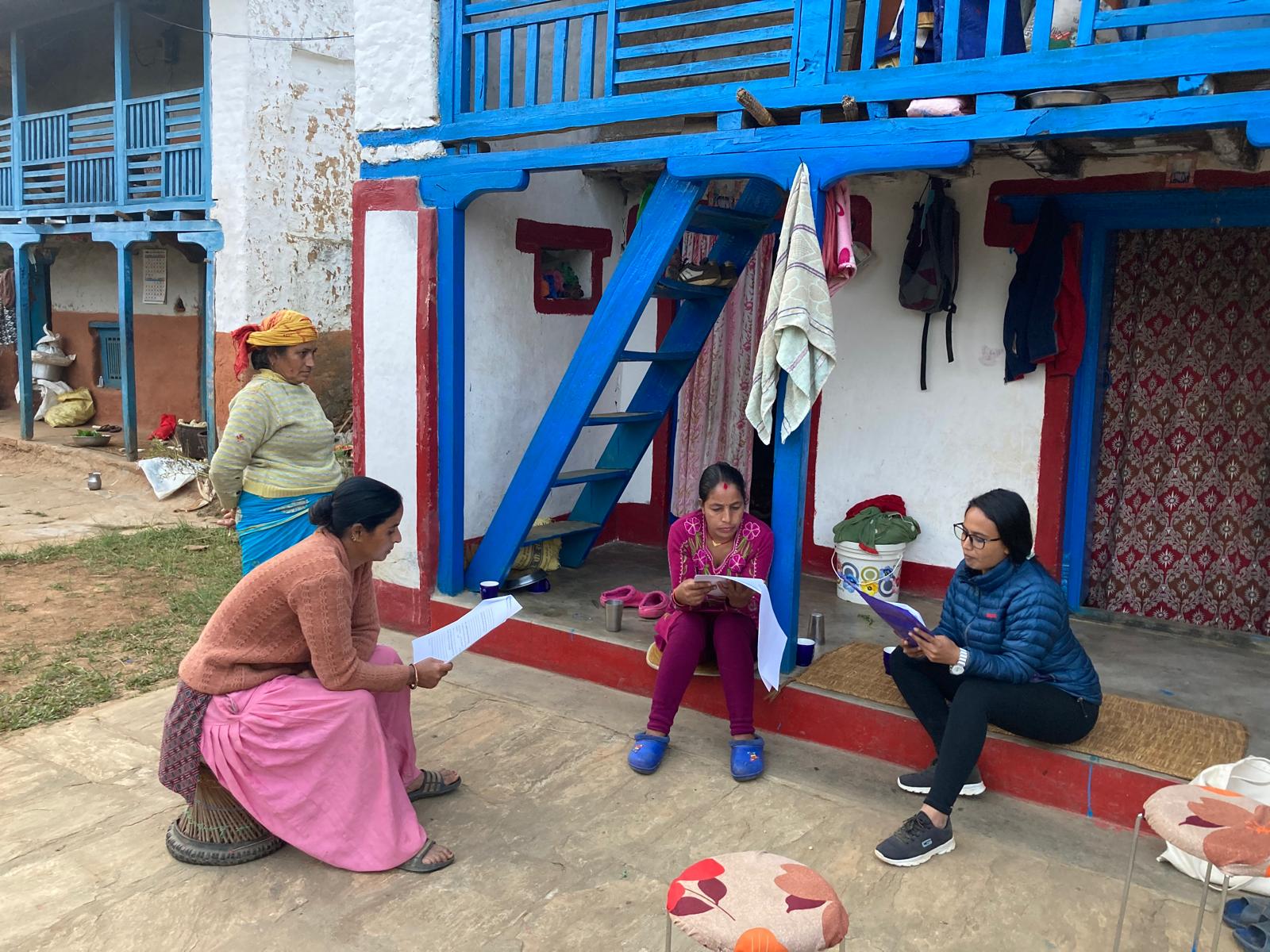
This building block outlines the findings and methodology of a nationwide field study conducted in 2022, which informed the Sparśa Pad Project. The research examined menstrual product usage, access, stigma, and user preferences among 820 Nepali women and adolescent girls in 14 districts across all seven provinces.

Using a structured face-to-face interview approach, the team employed ethically approved questionnaires administered by culturally rooted female research assistants. This method ensured trust, context sensitivity, and accurate data collection across diverse communities. The interviewers were trained in ethical protocols and worked in their own or nearby communities, thereby strengthening rapport and enhancing their understanding of local norms, power relations, and languages.

Key findings revealed a high reliance on disposable pads (75.7%) and ongoing use of cloth (44.4%), with product preferences strongly shaped by income, education, and geography. Respondents prioritized absorbency, softness, and size in menstrual products. While 59% were unfamiliar with the term “biodegradable,” those who understood it expressed a strong preference for compostable options, over 90%. Importantly, 73% of participants followed at least one menstrual restriction, yet 57% expressed positive feelings about them, seeing them as tradition rather than purely discriminatory.

These findings directly shaped the design of Sparśa’s compostable pads, informed the user testing protocols, and guided the development of targeted awareness campaigns. The accompanying link and PDFs include a peer-reviewed research article co-authored by the team and supervised by Universidade Fernando Pessoa (Porto, Portugal), as well as informed consent forms, a statement of confidentiality, and a research questionnaire. These documents are provided for practitioners' reference or replication purposes.

Why this is useful for others:

For Nepali organizations and local governments:

  • The study provides representative national data to inform product design, pricing strategies, and outreach campaigns.
  • It reveals regional, ethnic, and generational differences in attitudes that are essential for localized intervention planning.
  • The questionnaire is available in Nepali and can be adapted for school surveys, municipal assessments, or NGO projects.

For international actors:

  • The research demonstrates a replicable, ethical field methodology that balances qualitative insight with statistically relevant sampling.
  • It offers a template for conducting culturally sensitive research in diverse, low-income settings.
  • Key insights can guide similar product development, health education, and behavior change interventions globally.

Instructions for practitioners:

  • Use the attached PDFs as templates for conducting your own baseline studies.
  • Adapt the questions to reflect your region’s cultural and product context.
  • Leverage the findings to avoid common pitfalls, such as overestimating awareness of biodegradable products or underestimating positive views on restrictions.
  • Use the structure to co-design products and testing tools that truly reflect end-user needs.


  • Long-term engagement of NIDISI, a NGO with operational presence in Nepal, enabled trust-based access to diverse communities across the country.
  • Partnerships with local NGOs in regions where NIDISI does not operate directly were essential to extend geographic reach. In Humla, one of Nepal’s most remote districts, the entire research process was carried out by a trusted partner organization.
  • Pre-research networking and stakeholder consultations helped NIDISI refine research tools, adapt to local realities, and align with the expectations of communities and local actors.
  • Research assistants were female community members selected through NIDISI’s existing grassroots networks and recommendations from NGO partners, ensuring cultural sensitivity, linguistic fluency, and local acceptance.
  • Field research relied on ethically approved, pre-tested questionnaires, with interviews conducted in multiple local languages to ensure inclusivity and clarity.
  • Interviews were conducted face-to-face and door-to-door, prioritizing trust and participant comfort in culturally appropriate ways.
  • The study included a demographically diverse sample, representing various ethnic, educational, religious, and economic groups, strengthening the representativeness and replicability of the findings.
  • Academic collaboration with Universidade Fernando Pessoa (Portugal), where the research formed part of a Master's thesis by a NIDISI team member, ensuring methodological rigor and peer-reviewed oversight.
  • Language and cultural barriers can compromise data accuracy; working with local female facilitators from the same communities was essential to ensure comprehension, trust, and openness.
  • Social desirability bias limited the honesty of some responses around menstrual stigma. Conducting interviews privately and individually helped mitigate this, especially when discussing taboos or product usage.
  • The combination of quantitative surveys with qualitative methods (open-ended questions, observations, respondent quotes) enriched the dataset and provided both measurable and narrative insights.
  • Flexibility in logistics was crucial. Travel difficulties, seasonal factors, and participant availability—especially in rural and remote areas—required adaptable timelines and contingency planning.
  • Respecting local customs and religious norms throughout the research process was vital for ethical engagement and long-term acceptance of the project.
  • Training research assistants thoroughly not only on tools, but also on the ethical handling of sensitive topics, significantly improved the reliability and consistency of data collected.
  • Some communities initially associated the topic of menstruation with shame or discomfort, and pre-engagement through trusted local NGOs helped build the trust necessary for participation.
  • Pilot-testing the questionnaire revealed linguistic ambiguities and culturally inappropriate phrasing, which were corrected before full deployment—this step proved indispensable.
  • Remote district such as Humla required alternative model: relying fully on local NGO partners for data collection proved both effective and necessary for reaching hard-to-access populations without extensive budget burden.
  • Participant fatigue occasionally affected the quality of responses in longer interviews; reducing the number of questions and improving flow would significantly improve participant engagement.
  • Engaging with younger respondents, especially adolescents, required different communication strategies and levels of explanation than with older adults. Age-sensitive adaptation improved both participation and data depth.
  • Documentation and data organization during fieldwork (e.g. daily debriefs, note-taking, photo documentation, secure backups) was essential for maintaining data quality and enabling follow-up analysis.
Agreement on Designating and Demarcating Restoration Sites

To ensure effective restoration, project leaders worked with the community to designate and physically demarcate specific areas for intervention. This included mapping the landscape to identify priority areas for rangeland restoration, addressing concerns over land ownership, and ensuring community consensus on where boundaries would be drawn. The collaborative designation process allowed for clear agreements on how the land would be used, while physical markers helped prevent future conflicts over land use and maintain restoration areas.

  • Community-Driven site identification      and Planning: Engaging the community in mapping exercises fostered a shared understanding of the landscape and prioritized areas needing urgent intervention.
  • Clear Boundary Markings: Physically marking boundaries (e.g., with fencing or natural markers) and border patrols by community scouts provided clear, visible indicators of designated restoration areas, reducing misunderstandings over land use.
  • Consensus-Building Processes: Reaching community-wide agreements on site designation      increased local commitment to respecting and protecting these areas.
  • Clear Boundaries Prevent Conflict: Physically marked boundaries reduce potential disputes over land use, ensuring that restoration areas remain protected.
  • Local Input Enhances Relevance and Suitability: Community involvement in site selection increases relevance, as local knowledge helps identify areas that are both ecologically valuable and socially acceptable for restoration.
  • Ownership Through Shared Decision-Making: Engaging the community in boundary designation fosters a sense of ownership, increasing commitment to maintaining and protecting these restoration sites.
Organization of Community Meetings with Landowners (Local Barazas)

Community meetings, or barazas, served as the primary platform for engagement with landowners to discuss and align on proposed restoration interventions across 150 hectares of rangeland. These meetings were designed as participatory sessions where local Maasai landowners could voice their concerns, ask questions, and gain clarity on how the project would impact their land use. The barazas were instrumental in fostering transparent communication between project implementers and local stakeholders, allowing for an inclusive decision-making process that respected Maasai traditions and community dynamics.

  • Culturally Respectful Engagement Methods: Conducting barazas, a traditional community meeting format, allowed project leaders to approach discussions in a culturally appropriate manner.
  • Representation and Inclusion: Including landowners and community representatives ensured that diverse perspectives were heard and that decisions reflected the community's priorities.
  • Consistency and Follow-Up: Regular meetings provided a forum for ongoing dialogue and feedback, strengthening trust and adaptability to address any new concerns as the project progressed.
  • Transparency Builds Trust: Open and transparent discussions in barazas helped demystify the project’s goals, building trust and minimizing resistance among community members.
  • Community Ownership Leads to Better Alignment: When landowners are actively involved in the decision-making process, they are more likely to support and participate in the project, ensuring that interventions align with their land use priorities.
  • Iterative Feedback is Key: The regular nature of barazas provided continuous feedback, allowing the project to be responsive and adaptive to local needs and evolving challenges.
Ebauche de la Convention Locale, Pre-validation et Signature

Une ébauche de la CL est élaborée par les responsables définis lors de l’assemblée de restitution. Puis une pré-validation de la CL est nécessaire pour donner la possibilité des concernées de réagir même avant l’assemblée de validation. 

Dans le cas de Conventions moins complexes et/ou de petite envergure la distribution du draft aux concernées et le recueil des observations peut suffire. Dans les cas des CL complexes une assemblée de pré-validation est conseillé. A part des usagers et chefferie traditionnelle à mettre un accent particulier sur la commune et les ST. 

Lors d’une assemblée de validation, un rappel de tout le processus d’élaboration de la CL mène à la présentation de l’ébauche de la CL. Cette présentation doit être exhaustive. Plus les différentes parties prenantes étaient impliqués auparavant, moins il y aura des amendements. 

Le résultat attendu est une convention finalisée et signée par toutes les parties, conférant un cadre légal et moral aux actions de restauration. 

Outils :  Comme déjà au moment des assemblées précédents les outils de visualisation et de structuration des discussions jouent un rôle très important.

  • Assemblées inclusives pour révision et approbation.
  • Pour assurer que les discussions vont en profondeur, la distribution des textes des ébauches avant la tenue de l’assemblée est conseillée
Campagne d’information et Lancement du processus d’élaboration de CL

Souvent le besoin pour l’élaboration d’une CL est senti par une partie des concernés seulement. C’est la raison pour laquelle une campagne d’information et de sensibilisation concernant la problématique, les dangers et atouts de la ressource est obligatoire avant le démarrage des négociations.

A ce moment, la notion de Convention Locale et sa relation par rapport aux autres types de planification doit être clarifiée, ainsi que la suite des étapes pour son élaboration.

Une assemblée de lancement facilitera l’information des concernés sur les résultats déjà disponibles et le processus d’élaboration de la CL. 

Afin d’atteindre une représentativité il est important que les populations concernées, les usagers, les OP, la chefferie traditionnelle y compris les chefs de terre sont impliqués dans ce processus (voir étape précédente).  Lors de l’assemblée de lancement les différents groupes d’intérêt se rencontrent et les premières discussions sont lancées. 

Par la suite un Comité de Pilotage (CP) pour l’élaboration de la CL, et selon besoin, des groupes de travail thématiques (groupe analyse ressource, groupe élaboration règles, …) sont installés. Finalement les activités et étapes à venir sont planifiées dans le temps.

Outils : Rencontres en tête-à-tête, outils de visualisation (cartes, schémas), exemples pratiques de CL existantes.

  • Outils de communication efficaces et réunions inclusives
  • Si possible organisation de visites d’échange avec des CL réussis.
  • Les campagnes de sensibilisation augmentent l’adhésion et la participation locales
  • Ne pas continuer le processus en cas de conflits territoriales ou intérêts fortement divergentes
Participatory Forest Management Planning (PFMP) AND AGREEMENTS

The MTAKIMAU Mangrove Participatory Forest Management Plan (PFMP) 2024–2028 guides the sustainable management of approximately 2,550 hectares of mangrove forest across Mtwapa, Takaungu, and Kilifi. Developed under Section 47(1) of the Forest Conservation and Management Act (2016), the plan resulted from a highly participatory process led by the Mtakimau Community Forest Association (CFA), in collaboration with the Kenya Forest Service (KFS), WWF-Kenya, and other local stakeholders.

The process began with community barazas that restructured and registered the CFA. Stakeholders then formed and trained a Local Planning Review Team (LPRT), which conducted forest assessments, household surveys, participatory mapping, and community dialogues. Together, they designed the PFMP to define sustainable forest use practices, identify conservation priorities, and establish equitable benefit-sharing mechanisms. The plan reflects community aspirations, ensures ecological integrity, and builds climate resilience. KFS and the CFA formalized their partnership by signing a legally binding Forest Management Agreement (FMA) based on this plan.

  • Strong institutional collaboration between KFS, WWF-Kenya, the County Government of Kilifi, and local communities ensured technical and administrative support.
  • Early and inclusive community engagement, including village barazas and user group formation, fostered ownership and trust.
  • Capacity building of the Local Planning Review Team (LPRT) empowered community members to lead surveys, mapping, and planning activities.
  • Legal backing under the Forest Conservation and Management Act (2016) provided a clear framework for community participation and co-management.
  • Adequate financial and technical support from the Bengo Project (funded by BMZ through WWF-Kenya) enabled thorough data collection and plan development.
  • Early community involvement builds ownership and leads to more inclusive, practical management plans.
  • Training local representatives (LPRT) creates lasting capacity for community-led planning and decision-making.
  • Legal recognition of community forest associations (CFAs) is essential for formal co-management and accountability.
  • A multi-stakeholder approach strengthens the legitimacy, resource mobilization, and technical quality of the plan.
  • Field-based data collection and participatory mapping ensure that community knowledge and local realities shape the final plan.