Drone Data

Drones play a pivotal role in the 3LD-Monitoring system, complementing other data collection methods.Drones are essential tools in partner countries to fortify technical skills among local staff. These skills encompass flight planning, navigation and image evaluation. The drone monitoring aims to empower project staff to capture data tailored for photogrammetric analyses, from which crucial geoinformation emerges.

The drone mapping methodology encompasses five stages, with the first two focusing on drone operations:


  1. Mapping mission preparation (desktop work)
  2. Mapping mission execution (fieldwork)
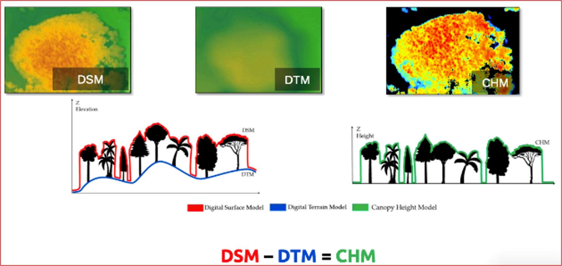
  3. Development of Digital Surface Model (DSM) & Orthomosaic generation (desktop work)
  4. Data analysis and refinement (desktop work)
  5. Integration into the prevailing data system (desktop work)


Drone data aids in evaluating indicators linked to carbon/biomass, such as mortality rates and forest types. Notably, with the application of allometric equations and proper characterization of the land type, above-ground biomass estimations of trees can be determined.

Drones with pre-set flight planning capability ensure seamless orthophoto creation from individual images. This enables individual snapshots to seamlessly merge into an orthophoto (aerial photograph corrected for distortions, allowing accurate measurements). It's also vital to consider the availability of these drones in the local markets of partner countries. Leveraging local knowledge by involving local academia is paramount in this process. They can provide essential allometric equations, grounded in tree height, that facilitate precise biomass calculations.

Drones generate high resolution images, allowing a detailed overview of land cover changes, tree survival and erosion rates, among others. Combined with field data, drone-based monitoring is strengthened, guaranteeing a sound monitoring.


The heterogeneity of trees and vegetation density often hinders a sound extraction of common key points between the images, which is necessary to estimate the heights and other indicators. In this regard, increasing the overlap between images to a minimum of 85 % frontal and side overlap can improve the extraction of key points. Also, increasing the flight height of the drone reduces perspective distortion, which facilitates the detection of visual similarities between overlapping images. However, too much overlapping, i.e., high overlapping percentages result in higher amount of data, making data processing more time intensive.


Another aspect already mentioned is the availability of suitable drones in the partner countries. Importing drones to the respective countries is difficult, and bureaucratic barriers persist.

Satellite Data

Satellite data forms the bedrock of the 3LD-Monitoring system, harnessing the capabilities of open-source imagery from the Copernicus Sentinel-2 and LANDSAT satellites. An algorithm, meticulously developed by Remote Sensing Solutions (RSS) GmbH, revolutionizes this process. Users can seamlessly submit the shapefile of their area of interest, prompting the algorithm to automatically fetch and analyze relevant data. A spectrum of robust analyses are conducted including the 5-year vegetation trend using NDVI for assessing vegetation gains or losses, 5-year vegetation moisture analysis through NDWI, and a nuanced 5-year rainfall trend evaluation. Additionally, the algorithm facilitates the visualization of vegetation changes since the inception of the project, bolstering the monitoring framework with dynamic insights. Satellite data, a vital component of the 3LDM-Monitoring system, leverages open-source imagery from the Copernicus Sentinel-2 mission and LANDSAT satellites. For predefined areas, this data is automatically fetched and analyzed for specific parameters. Key analyses include a 5-year vegetation trend using NDVI as a proxy for vegetation gains or losses, a 5-year vegetation moisture trend through NDWI, and a 5-year rainfall trend. In addition vegetation changes from project start can be visualized.

Effective use of this building block hinges on users drawing and saving areas in GIS platforms like QGIS. Additionally, enhancing the shapefile with project specifics, such as start dates and FLR type, optimizes analysis. Proper training in these skills ensures accurate data input and tailored monitoring, making capacity building in these areas essential if not present.

While satellite data, especially open-source, offers broad insights, its capability for species identification is highly restricted, if not unattainable. This limitation emphasizes the indispensable role of field work in discerning species composition and characteristics. Additionally, understanding the innate constraints of satellite imagery, especially with young tree plantations, reinforces the need for integrating field and drone data to gain a comprehensive view of forest terrains.

Field Data

Satellite and drone images, despite their undeniable contribution for monitoring, they are limited in the initial years of FLR efforts. Data collection at field level is crucial in the first projects years.


Data collection at field level is further divided into three participative approaches:


  • Permanent sampling plots: Fixed plots, where tree height, DBH, and tree survival rates will be estimated. Permanent sampling plots will be assessed in 3-year interval, due to their high labor and time input.
  • Land use planning: discussion rounds for the assessment of information, as well as identification of endangered species according to the Red List of Threatened Species by the World Conservation Union (IUCN). It is integrated into other land use planning processes, and thus, has not a defined assessment interval.
  • Transects: Identification of floristic and faunistic species, as well as forest structure composition, in an assessment interval of three months

All relevant indicators included in the three participative approaches are collected using the KOBO Toolbox. This software offers suitable conditions and is easy to operate, aligning with the monitoring objectives of the project.

A participative approach is essential in guaranteeing a long-term monitoring of the restored areas. The symbiosis of local knowledge and training/capacity building of local staff and regional partners is the core of this approach. Identifying the needs of the community, organizing discussion rounds, involving the local community in the developing and testing of the monitoring system, encourages consciousness and connection to the restored landscape.

  • Field Data Priority: In early FLR stages, field-level data collection is more effective than relying solely on satellite and drone images.

  • Participative Approaches: Employing participative methods like permanent sampling plots, land use planning, and transects involves local communities and enhances monitoring.

  • Appropriate Technology: Using user-friendly tools like KOBO Toolbox aligns well with project objectives and simplifies data collection.

  • Local Community Engagement: Engaging and training local communities ensures long-term success and fosters a connection to the restored landscapes.

Develop a Follow-Up and Monitoring Plan

The objective of this building block is to provide technical teams with parameters for measuring the effectiveness of restoration actions in the field.

The monitoring plan should include elements to evaluate the following parameters: 1) degree of development of planted species and their response capacity, 2) changes in water patterns and abundance, 3) changes in biodiversity dynamics (presence and abundance), as well as in the disappearance of exotic and/or invasive species, 4) changes in the environmental conditions of the area, and 5) changes in land dynamics and use, as well as public use and community demands.

  • Social auditing favors accountability in the quality and quantity of public investment in the territories.
  • Co-administration or co-management agreements favor accountability in the quality and quantity of non-governmental investment in the territories.
  • The creation of local governance platforms favors the creation of robust and transparent accountability systems.
  • The data provided by the monitoring system should have a technical component (how have we progressed in the restoration of our area?) and a social component (what are the monetary and non-monetary benefits of the investments made?), so that the actors involved maintain a real and effective interest in contributing to the restoration of these sites.
Elaborate a Zoning Proposal and Restoration Plan.

The objective of this building block is to provide the technical teams with the technical parameters to identify the sites where restoration should be carried out and the selection of effective actions for ecosystem recovery.

Zoning requires: 1) identification of areas for natural and assisted recovery, 2) areas for reforestation with native and endemic plants, and, 3) areas with potential for environmentally friendly productive activities.

The proposal for restoration actions includes: 1) the selection of activities to be implemented for each zoned area, 2) the estimation of resources needed to implement the restoration activities, 3) the distribution of responsibilities according to the competencies and resources available to the interested parties, and 4) the time required to implement actions taking into account the scope and resources available.

  • The quality of the previous diagnoses, the experience of the technical staff that accompanies these processes and the active participation of the stakeholders, facilitates decision making and the most cost-effective selection of restoration activities at the intervention sites.

The ecosystem functions to be restored, as well as the ecological and social context, determine the type of activities to be chosen and the geographic area to be intervened:

  1. Where opportunities exist to enhance biodiversity at the landscape level, activities should concentrate on sites located in or around protected areas or other forests of high conservation value.
  2. Where degradation has led to ecosystem functioning failures, activities should be concentrated along riparian strips, steep slopes, etc.
  3. Where opportunities exist to improve human well-being and, in particular, to support income-generating activities, priority areas should be appropriate sites for the production of high-value species.
Elaborate a Diagnosis on the State of Biodiversity and Socio-Economic Situation.

The objective of this building block is to provide technical teams with the biological parameters necessary to determine the current state of an ecosystem in order to determine the appropriate restoration measures to be implemented in that specific ecosystem.

The diagnosis of the state of the biodiversity is done by documentary review and field visits, where we perform: 1) identification of the site including the composition, structure, and different strata that make up the ecosystem, 2) description of the ecosystem services, 3) floristic composition, 4) diversity of vertebrate and invertebrate fauna groups, 5) presence of invasive species, and 6) identification of threats and degradation factors.

The socio-economic situation is carried out by documentary review and field visits, where the following is done: 1) identification of the current users of the site, 2) description of the productive activities carried out by the users, 3) clarification of the land tenure status of the site, 4) identification of local actors with presence in the territory, 5) identification of the potential local development with ecologically sustainable activities.
  • The sites should be referably of high national interest for the provision of ecosystem goods and services for the population and the conservation of existing Natural Protected Areas that are legally endorsed.

  • Have resources available for the incorporation of additional analysis such as GIS and other technological tools, which facilitate the delimitation and rapid characterization of the sites to have a first approximation of the general conditions.

  • The process can be demanding due to the level of detail and interdisciplinarity required. Therefore, it is necessary to plan the time, human and material resources that will be used for the documentary, geographic and field analyses.
  • Involve local stakeholders from the beginning to ensure the sustainability of the actions, take advantage of local knowledge and interest in the conservation of ecosystems for the benefits they obtain from them.
Efficient Monitoring, Reporting and Verification (MRV) system

Compared to similar carbon projects in agriculture, the Western Kenya Soil Carbon Project piloted an efficient Monitoring, Reporting and Verification (MRV) system. By using a modelling approach instead of pure activity monitoring, monitoring costs of the scheme could be decreased significantly. Also, the pilot uses digital monitoring tools (app), which makes the MRV more efficient. The digitalized MRV system provides the potential to integrate commodity market platform access for smallholder farmers. 

Sufficient financial resources to ensure the availability of digtial tools are important. Moreover people need to be available in the field to introduce farmers to the digital tools like apps and help with problems and questions. A coordination entity to supervise this but also the whole MRV process and its quality is thus a key component.

Increasing the efficiency of carbon schemes requires reduction of transaction costs, for example by applying satellite-based SOC monitoring or digital extension service support systems. To improve partner countries' national climate MRV system efficiency, it is recommended to link carbon projects MRV to national carbon registries. 

step-by-step implementation

the new site management approach will be implemented progressively, in stages. The corresponding deliverables will be proposed and discussed by the site's Scientific Committee and the Natura 2000 site's COPIL.

In order to gradually adapt an exemplary conservation management approach to combat habitat closure, specific studies have been carried out to assess the effectiveness of mowing and grazing, based on changes in vegetation and flora taxa since at least 2010. These studies were based directly on multi-taxon inventories carried out at regular intervals on the marsh. These elements are taken into account in the site's 2023 action plan.

Consequently, short- and medium-term management actions have been identified. In the short term, it is planned to carry out selective clearing and crushing of the overgrown areas (grazed area), with export of the cuttings. Similarly, it is proposed to maintain mowing techniques in the northern zone.

In the medium term, it is recommended to continue ecological monitoring of the conservation status of open environments (every 5 years), as well as monitoring of heritage flora and entomofauna.

concerted management

As part of the implementation of the new management plan, a scientific committee will meet regularly to discuss the development of the site and the state of conservation of the natural environment. The effectiveness of concerted, shared governance and management has been demonstrated on the site.

The Scientific Committee brings together experts who have worked on the site, as well as the relevant government and local authorities. It is thus representative of local, institutional and scientific players (also in the context of the site's classification as an APPB (Arrêté Préfectoral de Protection de Biotope).

The effectiveness of concerted, shared governance and management has been demonstrated. As a result, the site is currently involved in :

- work carried out by the Conseil départemental's own management team of 7 agents specialized in work on natural areas;

- work carried out by companies specializing in the management of natural environments, within the framework of public contracts with technical specifications adapted to work in sensitive natural areas (mowing equipment adapted to fragile soils in particular);

- monitoring of the work carried out and its effectiveness, through regular studies carried out by specialized firms, as well as sharing of information at meetings of the Natura 2000 "Basse Vallée du Loing" steering committee and the scientific committee for the Episy marsh.

landscape diagnosis and perception

Current management principles (such as late mowing for export) are considered favourable and should be maintained. In order to preserve the mosaic of habitats and landscapes of the low-alkaline peat bog (northern sector), management actions should be considered to contain the cladia that is advancing on typical low-alkaline mire habitats. Localized sprigging could limit the expansion of the Marisque. In addition, management practices need to be correlated and refined with the ecology and location of the heritage species present.

In order to provide a regular diagnosis of the state of health of the site's environments and landscapes, a number of measures are implemented:

  • regular inventories of vegetation and flora by the Department's service providers to assess the effectiveness of management measures implemented
  • implementation of a new management plan as of 2023, based on an adapted reference framework, to target the best management measures
  • creation of a scientific council in 2023, which will meet regularly to discuss the site's evolution

Ecological studies carried out on the site in 2022 and 2023 determined that the ratio of mowing to grazing areas (considering the northern and southern parts of the site) was balanced and conducive to habitat conservation and the maintenance of vegetation diversity. In view of this favorable result, the current split between mowing and grazing is maintained.

With regard to the grazed southern sector, and considering that the overall grazing pressure reflects a punctual trend towards progressive closure (grazing refusals, woody rejections), it was deemed worthwhile to undertake the following actions in the short term:

  • selective clearing of undergrowth and crushing of overgrown areas, with export of cuttings;
  • introduce rotational grazing and consider enclosing certain areas.

Lastly, we need to monitor the evolution of the woody cover to justify whether or not it is appropriate to carry out one-off interventions, which can be costly and time-consuming.