Globally, fish consumption shows strong regional differences. For instance, in 2009 the average yearly fish consumption per capita in Africa was 9kg, while in Asia it reached almost 21kg per person. On every continent, small island developing states or coastal countries have higher consumption rates than their landlocked counterparts. In addition to these differences, the FAO State of World Fisheries and Aquaculture report of 2022 predicts these regional imbalances to increase in the future while fish consumption in Africa is expected to further decline.
These observations are consistent with the findings of the baseline studies conducted by the GP Fish, which found that the median annual fish consumption per capita was 0.9 kg in Malawi (2018), 1.1kg in Madagascar (2018), 1.8 kg in Zambia (2021), but 24.4kg in Cambodia (2022). It must be noted that these consumption patterns reflect the situation of the rural population, who typically have lower incomes compared to the national average. Considering the recommended average yearly fish consumption of 10 kg per person, these findings are worrying.
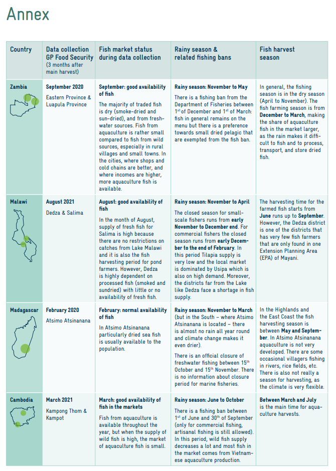
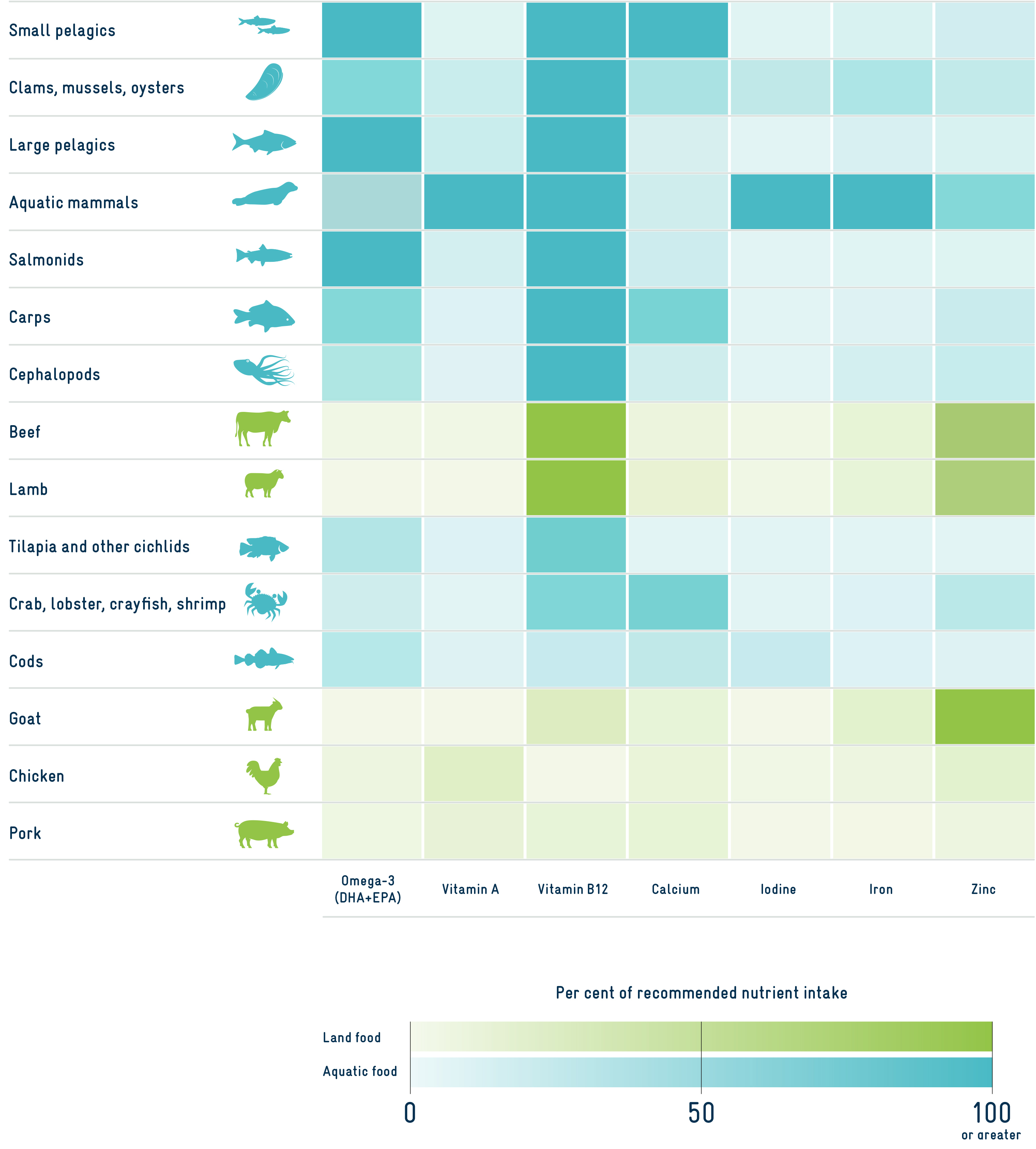
Considering the importance of fish as a protein and nutrient source for rural households it is important to better understand fish consumption patterns and their impact on food and nutrition security. In Malawi, Madagascar, Zambia and Cambodia the GP Fish and the Global Programme Food and Nutrition Security, Enhanced Resilience (GP Food and Nutrition Security hereafter) are working together to improve food and nutrition security. While the data from the GP Fish are focused on fish production and consumption of close by consumers, data from the GP Food and Nutrition Security provide information about the consumption of different protein sources by the Individual Dietary Diversity Score (IDDS). The GP Food and Nutrition Security collected data from women of reproductive age living in rural, low-income households, not focusing on people involved in the fisheries and aquaculture sector and the surveys included questions to determine a household food security status. Using the extensive dataset allowed an assessment of the current role of fish in comparison to other animal and plant protein sources, without the bias of an increased fish consumption among households involved in fish production. Given that data collection was based on 24-hour recalls, the table in the Annex contextualizes the date of the survey with seasonal implications on fish availability (fishing ban, harvesting seasons), indicating that results can be considered representative.
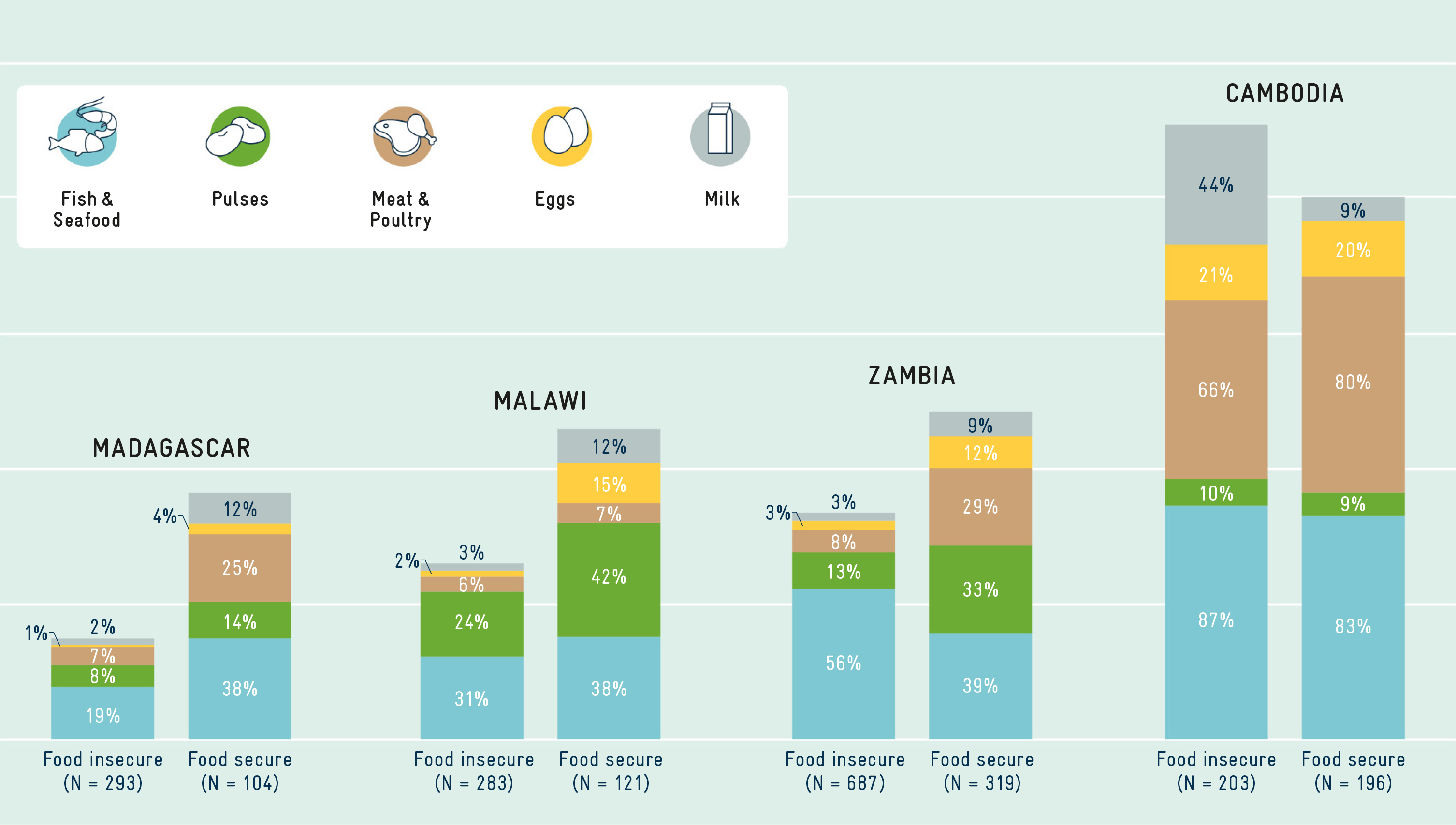
The frequency of the consumption of various protein sources over the last 24 hours, disaggregated by food security status, is shown in Figure 3. The food protein sources include fish and seafood, pulses (beans, peas, lentils), meat and poultry, eggs, and milk and dairy products. The percentages indicate how many of the respondents consumed a particular protein source (e.g., 19% of the food insecure women in Madagascar have consumed fish and seafood in the last 24 hours). The overall height of the column indicates the aggregated frequency of protein consumption by respondents for each country. Lowest frequency of protein consumption within the last 24 hours for food insecure respondents was found in Madagascar and the highest in Cambodia.
Figure 3 reveals several interesting trends:
1. In general, fish is currently the most frequently consumed protein source in nearly all countries. The importance of fish as a protein source can be explained by the fact that fish is often more affordable, more accessible, and culturally preferred compared to other animal- or plant-based protein sources.
2. Food secure respondents do not in general consume fish more frequently compared to food insecure respondents. This indicates that fish is a source of protein and nutrients that is accessible also to the most vulnerable, namely the food insecure population.
3. The results show regional differences in the frequency of protein consumption between African countries and Cambodia: in Madagascar, Malawi, and Zambia, between 19 – 56% of food insecure respondents and 38 –39% of food secure respondents have consumed fish during the last 24 hours, while in Cambodia more than 80% of the respondents consumed fish during the last 24 hours, independent of the food security status. These results are consistent with the abundance of fish in Cambodia, while access to fish in African countries is often limited by seasonality and distance from water bodies.
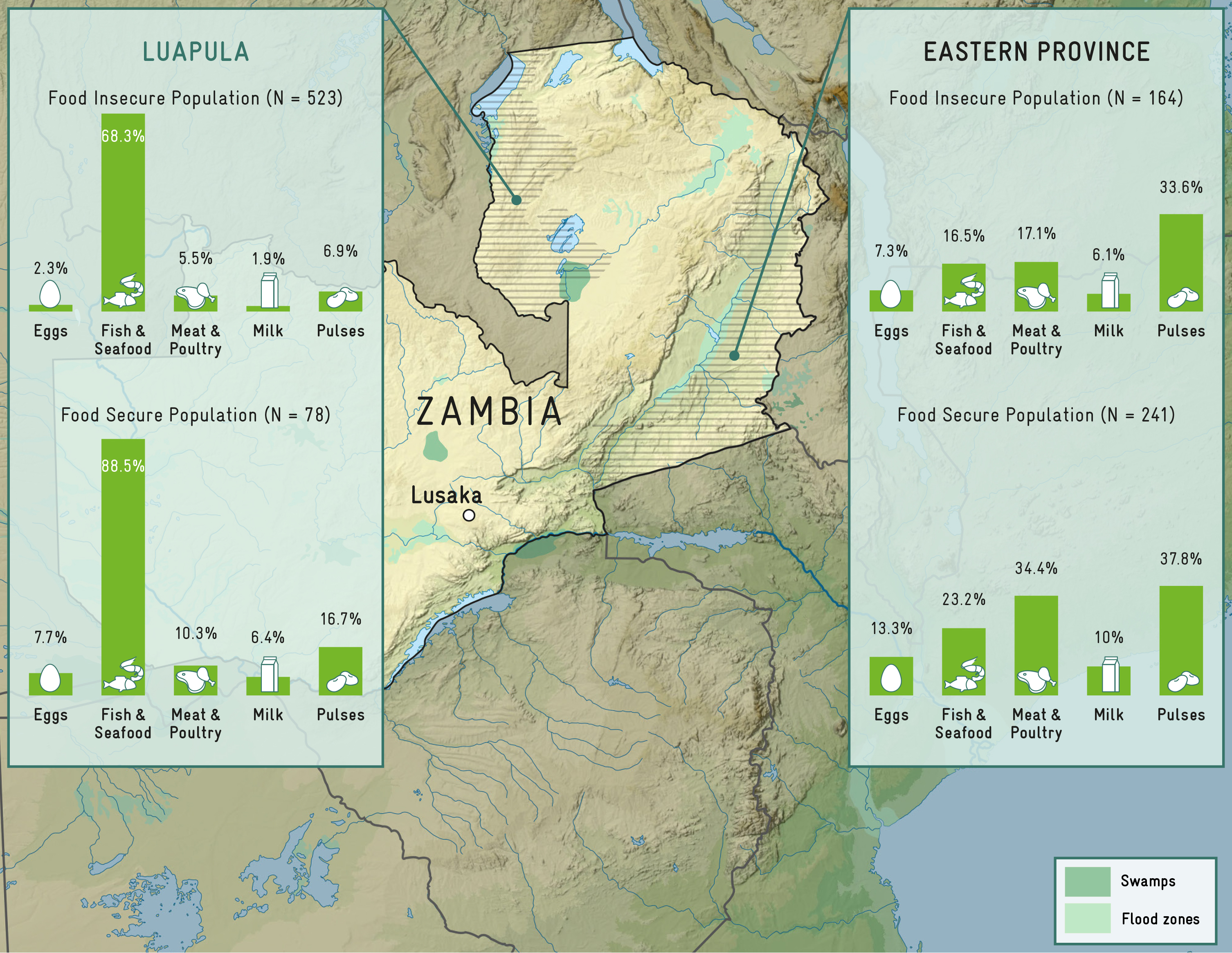
In addition to the differences between countries, Figure 4 illustrates high differences in consumption patterns within one country. In Zambia, the GP Food and Nutrition Security found fish to be a consumed by 68.3% (food insecure) and 88.5% (food secure) of the interviewed women in the last 24 hours, while in the Eastern Province, it was only 16.5% and 23.2% respectively. This is consistent with the results from the GP Fish survey, which found that the median annual fish consumption in Luapula Province was 2.2kg and 5.2 kg per capita, while fish consumption in Eastern Province amounts to only 0.9 kg for food insecure and 2kg per year for the food secure respondents. These results suggest that the Chambeshi/Luapula river system and connected wetlands in Luapula Province make fish more accessible than in the rather dry Eastern Province. For the success of new interventions in the field of food and nutrition security related to fish production and consumption, the local conditions and cultural context are important factors to consider during the planning process.