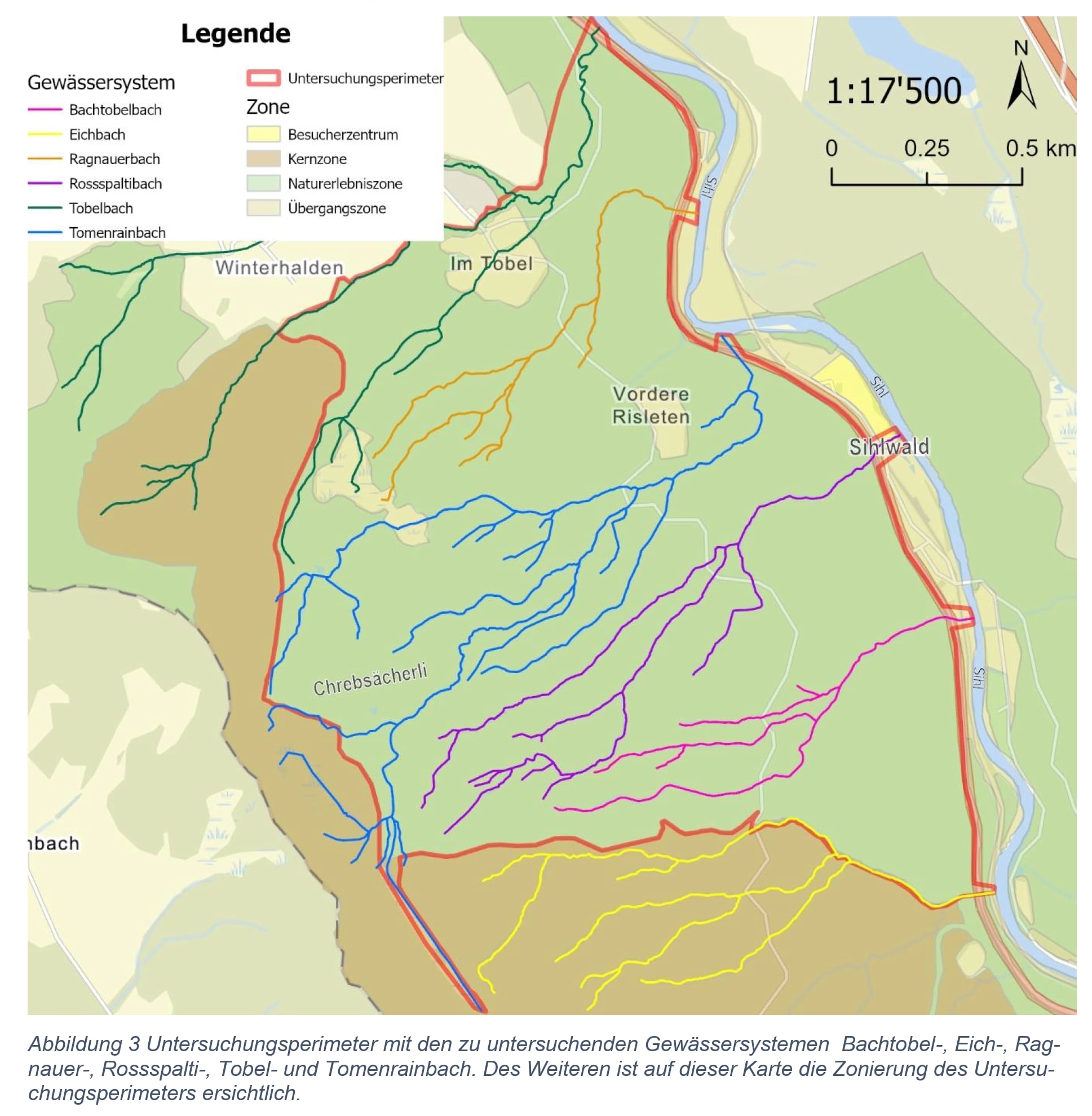
Delopment of the SIREN App

This building block is to explain how I developped an App that allow fishers to contribute to marine science knowledge in Africa. 

Initially we gave fishers a pre-printed form to report opportunistic sightings they encountered. However, the form was getting lost most of the time. 

We decided to move to a digital solution. The existing App by then required internet to work and was just too complicated for fishers. So we thought we shoud develop an App that will be more userfriendly for fishers. 

We wrote the  algorithm (workflow) of the App and then contracted an Indian development company to write the code. 

Later we had to bring the development of SIREN back to Cameroon to reduce the cost of developement. 

We work with volunteer around the world that will continuously support with the development of the SIREN

  • passion and determination
  • availability of seed fund to develop an initial version of the SIREN App
  • Collaboration with local App developpers
  • Extending the collaboration to international volunteers 
  • understand
  • The first developper company I contracted for the development of SIREN was a foreign company based in India. The cost of develpment was very high and there was a lot of miscomunication due to language barriers. When we started working with local developpers, the cost of development decreased importantly and it was easier to communicate.
  • Before giving a smarphone to fisher for data collection you must develop a trust relationship with him before otherwise the phone will never be used by the fisher to report sightings.
Mitigate biodiversity loss

Conserving ecosystems is key to curbing climate change, and maintaining ecosystem services (GBF target 11), which are closely linked to over 50% of the world’s GDP. Over 1 million species face the threat of extinction this century; however, selecting which areas to conserve is challenging with the existing data gap, which is biased towards observations in the global north. Increasing the amount of biodiversity data in the Global South is critical in the conservation of endangered species, found at high density in biodiversity hotspots in the Global South. Amphibians are ideal for acoustic identification due to their diverse vocalizations and are crucial ecosystem indicators (Estes-Zumpf et al., 2022), with over 40% of species at risk of extinction (Cañas et al., 2023). Increasing labeled data for the more than 7,000 amphibian species worldwide would enhance conservation efforts and reduce knowledge gaps in vulnerable ecosystems. By using a citizen science platform to aid in the mitigation of biodiversity loss, we help establish local environmental stewardship of these critical habitats (GBF Target 20).

Other citizen apps have shown the potential that citizen science has on mitigating biodiversity loss. eBird, the largest citizen science project related to biodiversity, has 100 million bird observations from users around the world. These observations help to "document the distribution, abundance, habitat use and bird trends through collected species list, within a simple scientific framework." (Sánchez-Clavijo et. al., 2024).  

iNaturalist, another citizen science app, that uses computer vision algorithms for species identification, has also proven successful in mitigating biodiversity loss. To date, the app has over 200,000,000 observations, with 6 million observations per month, globally. On iNaturalist, research-grade observations are shared with GBIF, which in turn uses that knowledge for policy decisions, research, and community building (GBIF, 2023). 

Currently, our app identifies 71 species of frogs and toads, worldwide. Though many of them are identified as least concern (LC) under the IUCN, we do have one IUCN endangered species, the Southern Bell Frog (Ranoidea raniformis). This lack of threatened species included, underscores the need for diverse practitioners to participate in bioacoustic ecological monitoring. Increasing data points on vulnerable species can serve to inform policy decisions using data-driven insights. Local communities and Indigenous Peoples will be a key asset in increasing the number of species included in the app, as their local knowledge allows us to track species in remote regions. 

  • Closing data gaps: get more data from citizen scientists, especially from local communities and Indigenous Peoples.
  • Enabling environmental stewardship: accessibility to a diverse set of users.

We initially set a goal to decrease data gaps in the Global South. However, getting access to enough calls for rare, cryptic, and endangered species in the Global South to train our model proved to be challenging. Therefore, to improve model performance, we turned our attention to as many species as we could tackle, worldwide. Getting users engaged worldwide will lead to more recordings in data-poor regions like the Global South, allowing us to retrain our model in the future with increased data on endangered, rare, and cryptic species. 

This user engagement perfectly aligns with multiple targets, the most evident one being GBF target 20: Strengthen Capacity-Building, Technology Transfer, and Scientific and Technical Cooperation for Biodiversity. But other targets are key in this building block: by increasing the data points, we will be able to identify invasive alien species, addressing GBF Target 6, as well as protecting wild species from illegal trade, by obscuring their location from users. This is aligned with GBF Target 5, which seeks to "Ensure Sustainable, Safe and Legal Harvesting and Trade of Wild Species."

Spatial Sensitivity Assessment of Biodiversity and Speleological Heritage to Mining

The Biodiversity Sensitivity Map provides a spatial representation of the varying degrees of vulnerability of conservation targets to mining-related impacts. It integrates biological and ecological characteristics of species and ecosystems, along with the influence of anthropogenic pressures, to create a comprehensive sensitivity gradient—referred to as the Biodiversity Sensitivity Index.

This index ranks the entire study area into four sensitivity classes, ranging from “Extremely Sensitive Areas” to “Less Concerning Areas”, with each category representing approximately 25% of the total area. The classification follows principles of systematic conservation planning, incorporating spatial representations of both the distribution and sensitivity of each conservation target.

Certain species, habitats, or ecosystem services are more vulnerable due to intrinsic biological or ecological traits, or due to their geographic location. Moreover, the model considers landscape-level attributes—such as environmental conditions that either support or hinder biodiversity persistence—that are not directly tied to the mining threat but are critical for understanding overall ecological resilience.

Importantly, only targets that are likely to become even more vulnerable in the absence of preventive or mitigation measures were included in the mapping, ensuring that the tool supports strategic planning and prioritization for conservation in the context of mineral exploration.

Key enabling factors for the development of the biodiversity sensitivity map included access to specialized knowledge through collaboration with the National Centers for Research and Conservation of Fauna (ICMBio), and utilization of the Biodiversity Extinction Risk Assessment System (SALVE) (https://salve.icmbio.gov.br), which contains occurrence records validated by taxonomic experts. Additionally, coordination with the National Center for Flora Conservation (CNCFlora) (http://cncflora.jbrj.gov.br/portal) was essential for the identification of priority conservation targets for flora.

The construction of the tool contributed to the improvement of participatory methods, considering that the involvement of different actors in the discussion and elaboration of PRIM Mining is crucial to guarantee transparency in the processes of defining targets and analysis parameters, increasing the reliability, robustness and scope of the results.

Identifying areas most impacted by mining activities - Impact Exposure Map

A process designed to estimate the chronic impacts of mining activities on the landscape—such as habitat loss, fragmentation, and degradation. This analysis generates a gradient of exposure for biodiversity and speleological heritage, indicating varying levels of environmental damage severity. The mining impact exposure map provides a spatial representation of the risks to which conservation targets are subjected, allowing for a detailed assessment of biodiversity vulnerability. Identifying the areas most intensely affected by mining enables more strategic and informed planning efforts to minimize biodiversity loss.

The process involves coordination with sectoral bodies, the systematization of environmental data, and the validation of results through expert consultation. The methodologies employed are scientifically validated, widely accepted by the academic community, and designed to be replicable across different regions and landscape scales.


The construction of this layer was made possible by the increasing efforts of MapBiomas to map all remaining forest cover at the national scale in Brazil, as well as the National Mining Agency (Agência Nacional de Mineração - ANM) for providing the polygons of authorized mining processes across the country.

Access to accurate spatial data for calculating landscape metrics, combined with a network of collaborating experts in the field, enabled a participatory and transparent development of the results.

We gained valuable insights throughout the development of this layer and significantly evolved our approach by actively sharing information with the mineral sector and research institutions.

During the construction of a synergistic impact layer for mining activities, we identified a significant gap in available data, quantitative metrics, and modeling frameworks necessary to incorporate well-documented impacts—such as noise generation, vibration, air pollution, and soil and water contamination—at this spatial scale. This process highlighted the critical need to enhance impact assessments by accounting for the synergistic and cumulative effects of mining activities.


Democratization of data

Ribbit's approach to data democratization represents a carefully curated process of citizen-driven scientific contribution. By leveraging existing public datasets from iNaturalist sounds and Anuraset, the application establishes a robust foundation for acoustic biodiversity monitoring. These initial datasets provide a comprehensive baseline for machine learning training, ensuring high-quality initial models for anuran identification.

The application's innovative data collection strategy goes beyond gathering information, implementing a rigorous quality control process for user-contributed data. Each citizen-submitted recording will undergo careful verification before potential contribution to the Global Biodiversity Information Facility (GBIF). This approach transforms passive data collection into an active, collaborative scientific process where citizens can meaningfully contribute to conservation research, addressing GBF Target 14, to "Integrate Biodiversity in Decision-Making at Every Level".

Critically, Ribbit maintains stringent data privacy and protection protocols. Recognizing the sensitive nature of ecological data, particularly regarding rare species and precise location information, the application implements strict user consent mechanisms. No user data will be shared or distributed without explicit, informed approval from the contributor, protecting both ecological subjects and citizen scientists' privacy.


  • Accessible technology: web app runs on desktop and mobile devices, and users may upload their data when no Internet is available. 
  • Robust quality control mechanisms: advanced evaluation of scientific quality recordings.
  • Ethical data governance: prioritization of user privacy and ecological sensitivity.
  • Periodical re-training of the model: the model is updated every six months, with training done on new species that are incorporated into the app and validated by annotators. 

When starting this project, we were aware of the anuran biodiversity data gap in the global south. However, we were surprised that as we attempted increase accessibility of our application and add qualitative data, there was a gap in language representation. Currently, our project is available in four languages (English, Spanish, Portuguese, Arabic),  increasing accessibility. We used the Wikipedia API to obtain general information about our species in these four languages, and noticed that while there was an abundance of data in English and Arabic, the information available was sparse in Spanish and even more sparse in Portuguese. Therefore, we envision a  future challenge will involve engaging diverse scientists, such as Spanish and Portuguese speaking scientists, to decrease the "Wikipedia data gap". Addressing this gap will be a crucial act in further democratizing and increasing accessibility of our solution.

Co-Designing Solutions with Grassroots & Indigenous Partners: Strengthening Community-Led Action for Inclusive & Sustainable Development

The evidence is building that granting Indigenous peoples & other local communities' control over their territories improves forest protection, as they are directly invested in the survival of forests & want to ensure that future generations can continue to live & thrive in them. Yet a lot of development, environmental & climate-related programs are not created in collaboration with the people who will be impacted by them. Therefore, our solution arose from the challenges that grassroots organisations & Indigenous & local communities brought to our attention. Those communities are the ones living all the forests illegalities & land tenure violations. By directly tackling their challenge it ensures the solution to be genuine & efficient. Working with them directly helps us to better understand the contexts they are facing & adapt the tool in consequence.  

  • Long-term, respectful partnerships with tool users & communities.  
  • Adaptability to react to changing contexts & local needs 

  • Adequate financial resources for operations & engagement’s sustainability   

  • Prior research into local traditions, culture & socio-economic conditions improve tool relevance, acceptance & impact.  
  • Trust & impact grows through deep listening, cultural sensitivity & respectful engagement. 

  • Real impact comes from working with, not just for, Indigenous & locally led organisations. Additionally, it grows when working with local grassroots organisations & not only with national level NGOs. 
Global Review of Initiatives and Strategic Planning

Before launching ENCOSH, a global review of existing initiatives addressing human-wildlife coexistence was conducted. This process included mapping relevant practices worldwide, analyzing their effectiveness, and identifying gaps in knowledge. A strategic plan was then developed to shape the platform's structure and objectives based on the insights gained.

The purpose was to build a strong foundation for ENCOSH by integrating proven practices and addressing identified challenges. This review ensured the platform was comprehensive and catered to global needs while promoting scalable and adaptable solutions.

  • Access to databases and reports from diverse regions and organizations.
  • Collaboration with conservation experts to evaluate initiatives.
  • A strategic framework to align the platform's goals with global conservation needs.
  • A global perspective is critical for addressing complex issues like human-wildlife coexistence.
  • Gathering and analyzing data require dedicated time and resources, but the insights are invaluable for informed decision-making.
  • Challenges included the variability in data quality and difficulty accessing certain resources. Establishing partnerships with organizations holding relevant data can mitigate these issues.
The nutrition value of fish

In the first step of the solution GP Fish seeks to provide evidence about the role of fish in addressing malnutrition and supporting healthy diets, particularly for food insecure households. It is directed to professionals working in the field of food and nutrition security as well as rural development and investigates questions like “Does fish feed the poor, or is it too expensive?” By combining scientific insights with hands-on data from years of field experience, supplemented by practical examples, it aims to provide a broad overview of the current state in selected countries and a path forward.

Malnutrition is the most important aspect of food and nutrition insecurity and comes in many forms: undernutrition, overnutrition, and micronutrient deficiencies, often referred to as “hidden hunger”. The latter represents a major public health concern and results from inadequate intake of nutrients, such as iron, zinc, calcium, iodine, folate, and different vitamins. Strategies to combat micronutrient deficiencies include supplementation, (agronomic) biofortification, and most importantly diet diversification, which is the focus of contemporary policy discourses concerning the improvement of human nutrition. Diversifying diets by consuming animal proteins can significantly prevent micronutrient deficiencies, especially in low-income food-deficit countries, where diets are predominantly carbohydrate-based. Fish is a highly nutritious food that provides proteins, essential fatty acids, and micronutrients, as shown in Figure 1, to the point that it is sometimes referred to as a “superfood”. Due to its nutritional properties, even small quantities of fish can make important contributions to food and nutrition security. This is particularly true for small fish species that are consumed whole – including bones, heads, and guts –in regions where nutritional deficiencies and reliance on blue foods are high.

Figure 2 shows the share of recommended nutrient intake when consuming aquatic vs. terrestrial foods. Food sources are arranged from highest (top) to lowest (bottom) nutrient density. Visibly, aquatic “blue” foods like fish and mussels, are richer in nutrients compared to terrestrial sources. They are specifically good sources for Omega-3 fatty acids and Vitamin B12. Therefore, “blue foods” not only offer a remarkable opportunity for transforming our food systems but also contribute to tackling malnutrition.

Planter Selection Criteria

This building block defines the criteria for selecting eligible tree planters and planting sites to ensure the success of the results-based incentive system. Participants include individual farmers and small community groups with land holdings ranging from 0.125 to 20 hectares.

Selection of planting sites is guided by established Land Use Plans (LUP), ensuring that the sites align with sustainable land management and restoration priorities. This approach helps optimize the ecological and socio-economic benefits of the plantations while reducing conflicts over land use.

The building block emphasizes proper identification of participants who meet the eligibility criteria and are committed to transforming their land into sustainable forests under the incentive system.

  • Clear Guidelines: Strict criteria requiring the inclusion of long-rotation and indigenous tree species alongside other tree species preferred by farmers.
  • Diverse Participants: Involvement of individuals and groups to ensure broad engagement.
  • Regulatory Compliance: Legalization of land ownership and documentation with GPS coordinates or shapefiles for transparency.
  • Community Trust: Transparent selection processes build trust and increase participation.
  • Documentation is Key: Using GPS or shapefiles for land boundaries enhances monitoring and transparency.
  • Varied Engagement: Including both individuals and organized groups fosters greater community involvement and ownership.
  • Secure Land Use Rights: Land use or resource use right certification is crucial to sustaining group plantings, ensuring long-term commitment and reducing potential conflicts.
Comprehensive life-cycle breeding program (Ex-Situ Conservation)

A comprehensive artificial breeding program was established over four years, producing 10,000 fish annually for conservation and reintroduction. Challenges included low genetic diversity and habitat-specific requirements.

  • A gene bank was established based on the concept of Noah’s Ark, aimed at increasing the population of the Formosan landlocked salmon through artificial breeding.
  • In 2000, the Formosan Landlocked Salmon Conservation Symposium was held, where a comprehensive conservation framework was developed. The goal was to gradually restore the five historical streams in the upper Dajia River, where the salmon originally thrived, within 30 years. A dual strategy of in-situ (on-site) and ex-situ (off-site) conservation was adopted.
  • Purely artificial breeding methods can reduce genetic diversity, so it is essential to establish a complete and sustainable breeding program.
  • There is limited experience in reintroducing endangered species, making it crucial to understand the life history and habitat requirements of the Formosan landlocked salmon.