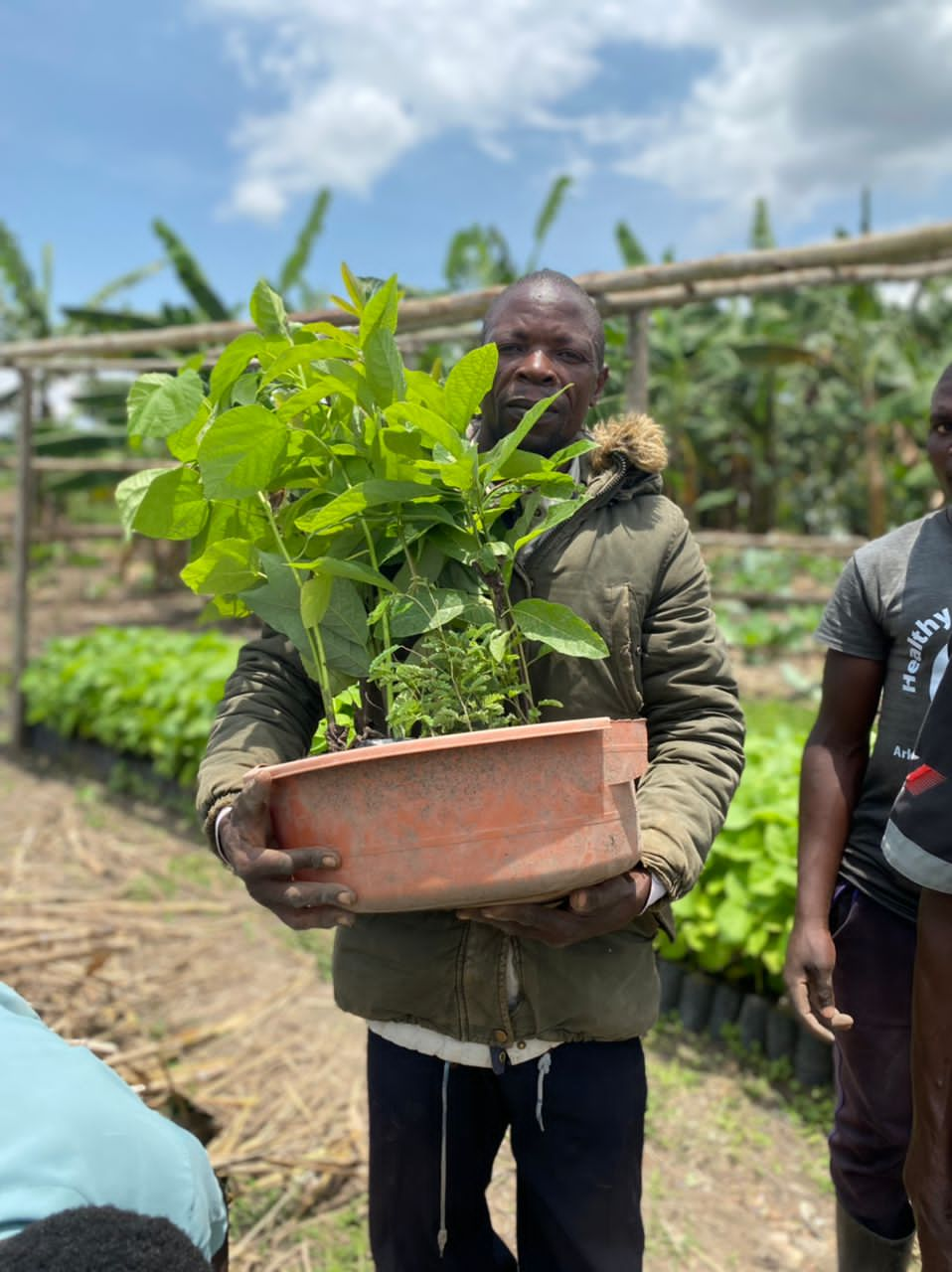
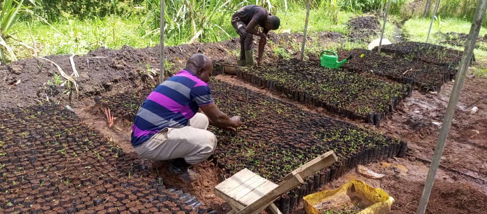
Delopment of the SIREN App

This building block is to explain how I developped an App that allow fishers to contribute to marine science knowledge in Africa. 

Initially we gave fishers a pre-printed form to report opportunistic sightings they encountered. However, the form was getting lost most of the time. 

We decided to move to a digital solution. The existing App by then required internet to work and was just too complicated for fishers. So we thought we shoud develop an App that will be more userfriendly for fishers. 

We wrote the  algorithm (workflow) of the App and then contracted an Indian development company to write the code. 

Later we had to bring the development of SIREN back to Cameroon to reduce the cost of developement. 

We work with volunteer around the world that will continuously support with the development of the SIREN

  • passion and determination
  • availability of seed fund to develop an initial version of the SIREN App
  • Collaboration with local App developpers
  • Extending the collaboration to international volunteers 
  • understand
  • The first developper company I contracted for the development of SIREN was a foreign company based in India. The cost of develpment was very high and there was a lot of miscomunication due to language barriers. When we started working with local developpers, the cost of development decreased importantly and it was easier to communicate.
  • Before giving a smarphone to fisher for data collection you must develop a trust relationship with him before otherwise the phone will never be used by the fisher to report sightings.
Collaborative Partnerships for Conservation

This building block focuses on the establishment of strong partnerships between academic institutions (Universidad Politécnica de Yucatán), local governments (Secretaría de Desarrollo de Sustentable del Estado de Yucatán), and conservation organizations (International Union for Conservation of Nature and Natural Resources), private sector (Huawei), and local communities (Dzilam de Bravo) to enhance the collection and analysis of biodiversity data, access to technological infrastructure, government program instrumentation and application, and local ownership and execution.

The purpose of this building block is to foster cooperation among diverse stakeholders to ensure the effective implementation of conservation technologies. These partnerships enable the sharing of resources and expertise, empowering local actors to participate in conservation projects and creating a framework for sustainability.

Enabling factors:

  • Strong engagement and alignment between stakeholders, including academic institutions, government agencies, conservation organizations, private sector and local communities.
  • Signed agreements that define clear roles, responsibilities, and benefits for all parties involved.
  • Access to local knowledge and expertise to ensure the relevance and effectiveness of conservation actions.
  • Transparent communication between stakeholders is crucial to build trust and ensure the long-term success of partnerships.
  • Including academic institutions fosters innovation and provides opportunities for student involvement in meaningful projects.
  • Government involvement helps to create conservation policies and facilitates execution in the community.
  • Partnerships with conservation organisations strengthen the scalability and visibility of conservation initiatives by pooling resources and knowledge.
  • Community of Dzilam de Bravo provides data on field and by taking ownership of the project, they contribute to efficient project execution 
  • Private sector provides infrastructure and expertise to facilitate the development of the technology
Advanced Image Recognition Algorithms for Jaguar Monitoring

This building block is centered on the use of Convolutional Neural Networks (CNNs), including Siamese and Autoencoder architectures, to detect and identify individual jaguars based on unique features such as rosette patterns and morphology. These algorithms process camera-trap data efficiently, reducing the time required for analysis and providing critical insights for decision-making in conservation.

The purpose of this building block is to enhance the monitoring and understanding of jaguar populations by automating the identification process. The algorithms detect jaguars in camera-trap images and classify individuals, contributing to understanding population size, distribution patterns, and behaviors. This facilitates conservation planning and policy-making by decision-makers. Additionally, the models are scalable and can be adapted to other species and ecosystems, expanding their applicability beyond the Yucatán Peninsula.

Enabling factors:

  • Availability of high-quality camera-trap data for training and validating the algorithms.
  • Technical expertise in AI and machine learning for developing and fine-tuning models.
  • Collaborative partnerships with local institutions for field data collection and algorithm design, development and testing.
  • Access to sufficient computational resources to train and deploy the algorithms effectively.
  • High-quality and diverse datasets are critical for achieving accurate and reliable results.
  • Community and academic involvement, such as the participation of the Dzilam de Bravo community and the Universidad Politécninca de Yucatán, enhances project outcomes by ensuring local capacity and ownership, and technological expertise to design the necessary algorithms.
  • Explainability in AI models (e.g., through Gradient Cam) is essential to build trust and ensure the results are accessible to decision-makers.
Comprehensive Data Ingestion for Fire Detection

This is the comprehensive intake mechanism for all information vital to PyroSense's platform. Its purpose is to gather real-time data, from multiple origins, ensuring the system has the input needed for accurate analysis and effective decision-making. 

PyroSense integrates an agnostic and highly compatible array of data:

  1. Environmental IoT Sensors are strategically deployed, and continuously collect real-time CO2, temp. and humidity data. They are agnostic in type and protocol, compatible with MQTT, LoRa, Sigfox, and NBIoT, ensuring broad integration. For efficiency, they feature long-lasting batteries (up to 10 years), minimising maintenance.  

  2. Fixed cameras and drones capture high-resolution images and live video. Integrated Vision AI processes this visual data in real-time to detect anomalies like smoke or fire. 

  3. PyroSense gathers data from local weather stations and satellites. Combining granular local data with broad satellite coverage provides a comprehensive understanding of current weather.

  4. GIS provides foundational spatial information, including maps of terrain, vegetation,  infrastructure, etc. 

  5. Firemen Wearables monitor real-time biometrics. AI enhances data for risk pattern recognition, of fatigue or heat stress. Real-time alerts are sent to nearby teams or control centers, enabling proactive intervention.

  • Reliable Sensor Deployment: Sensors should be strategically placed, well-installed, ensuring continuous data collection and security.
  • Data Stream Integration: Integrating data from various sensors, cameras, drones, and meteorological sources is crucial for situational awareness.
  • Data Quality and Calibration: Ensure all data sources are calibrated and high quality to avoid false alarms.  
  • Secure Data Transmission: A strong communication is vital for secure, low-latency data transfer from remote locations.

The diversity and agnosticism of data sources are critical for comprehensive and resilient fire detection. Relying on a single type of sensor or communication protocol creates vulnerabilities. The ability to integrate data from various IoT sensors, visual feeds (cameras, drones), meteorological data, and even human biometrics provides a robust, multi-layered detection system that significantly reduces false positives and increases detection accuracy.

  • The platform must be software and hardware agnostic.
  • Cybersecurity and intercommunication are crucial.

A significant challenge was ensuring seamless interoperability between different sensor types and communication protocols (e.g., MQTT, LoRa, Sigfox, NBIoT) from various manufacturers. As well as, maintaining connectivity in remote, terrains for all sensor types was also an ongoing effort, despite long battery life.

  • Design your system to be compatible with multiple IoT communication protocols from the outset. 
  • Develop algorithms for data validation and fusion to cross-reference information from disparate sources.
  • Consider hybrid communication solutions (e.g., satellite for remote areas)
Establishing a satellite-based IoT communication system

Relevant ecological processes and incidents that are of interest in environmental change research typically occur in remote areas beyond the reach of terrestrial communication infrastructures. Data generated in the field using animal tags in these regions can often only be transmitted with a delay of days or even weeks. To overcome this delay and ensure no delay in the early-warning system, GAIA develops a satellite communication module for the tags as well as a nanosatellite operating in low earth orbit (LEO): In order to be able to transmit collected data and information directly from the transmitting node to the LEO satellite (Low Earth Orbit), a high-performance satellite IoT radio module will be integrated into the new tags. This guarantees immediate, secure and energy-efficient transmission of the extracted data. The communication system is based on the terrestrial mioty® technology and will be adapted to satellite-typical frequency bands such as L- and S-band for the project. Typical communication protocols, which are sometimes used in the IoT sector, are usually designed for small packet sizes. Further development of the mioty® system will therefore also aim to increase the data rate and message size to enable application scenarios such as image transmissions.

The satellite IoT system will be key for a no-delay communication and thus for an early-warning system. It greatly contributes to the GAIA system in achieving GBF target 4 "Halt Extinction, Protect Genetic Diversity and Manage Human-Wildlife Conflicts". 

A significant share of the GAIA research and development was funded by the German Space Agency (DLR). This provided not only budgets for the development of the mioty® communication modules in the tags and first modules and concepts of the nanosatellites, but also access to an ecosystem of space-tech stakeholders. The start-up Rapidcubes became a key partner in the Initiative for the satellite development and plans for subsequent project phases include collaboration with existing DLR infrastructure such as the Heinrich Hertz satellite. 

The adaptation of the terrestrial mioty® protocols for satellite communication were successful. With the Ariane 6, an experimental nanosatellite was launched into a low earth orbit in July 2024. Since then, communication protocols are tested and refined for future application for the GAIA early-warning system.

Developing a new generation of animal tags and concepts for a digital swarm intelligence in networks of devices

To meet the goal of the GAIA Initiative to develop and put into practice a high-tech early-warning system for environmental changes, a new generation of animal tags is a key component. GAIA teams are working on the hardware and software development of miniaturized animal tags with lowest-power sensor technology with camera and image processing. The tags will be energy-autonomous, optimally adapted to the anatomy of vultures and are the basis for further technological features under development such as on-board artificial intelligences for behaviour detection and image recognition as well as a satellite-based IoT communication system.

Additionally, GAIA is developing concepts of distributed artificial intelligence and networks of micro-processors – animal tags that act just like a swarm. Analogous to natural swarm intelligence, the GAIA initiative is mapping digital swarm intelligence in an ad hoc network of microprocessors. These spontaneously forming networks are the foundation for distributed and sensor-based analysis of large amounts of data. Following this path will make it possible for vulture tags, for example, that are present at the same location during feeding events, to link and share tasks such as artificial intelligence analyses and data transmission.

A key factor for the success of this building block is the interdisciplinary and cross-sectoral cooperation of the GAIA partners: The Leibniz-IZW provided biological and veterinary knowledge about vultures and provided goals for the technical design of the new tags. The Fraunhofer IIS provided expertise in energy-efficient hardware, electronics and mechanics as well as in software for the miniature units. The Zoo Berlin provided environment and access to animals to aid the design and test the prototypes at various stages. Partner organisations in Africa such as Uganda Conservation Foundation provided an environment for in-depth field tests of the tag prototypes.

After several years of design and development, prototypes of the new tag system were tested in the wild in Uganda in November 2024. Wild white-backed vultures were equipped with prototypes called “data collection tag” (DCT) that featured many (albeit not all) innovations of the GAIA tag. The tags were released after 14 days from the vultures and collected using GPS and VHF signals, allowing for thorough examination of hardware and software performance as well as evaluation of collected data. These analyses will greatly help further developing the system.

Strengthening Multilevel Advocacy Networks Among NGOs to Amplify Collective Action

Using a digital tool to collect & analyse data is innovative, but real impact comes from applying that data to support advocacy & law enforcement for the protection of forests & local communities & Indigenous peoples’ rights. To this end, strong local, national & international advocacy networks are needed to take action against reported abuses & to achieve legal & policy changes. By enabling information to be shared between users & opening up data to the general public when consent has been given, the tool facilitates collaborative working for greater impact.  

  • Collaborating with NGOs that share similar values & goals strengthens collective impact 
  • Coordinated data verification & analysis supports timely, unified advocacy. 

  • Partnering with local organisations specialising in legal advocacy enhances impact 

  • Strong relationships with trusted national & international institutions help validate & promote the tool. 

  • While building NGOs networks is important, it is also vital to respect when organisations choose not to collaborate. Supporting each local NGO individually - & avoiding competition - requires flexibility in project design & donor engagement. 
  • To ensure networks’ sustainability, medium- & long-term funding is essential to keep coordination efforts running smoothly (secretariat costs etc.).  

  • Support to local and national NGOs on organisational development is key to allow them to participate effectively in networks.  

Regular evaluations

To ensure that fish production supported by the GP Fish is an accessible protein source also for the most vulnerable, GP Fish regularly tracks fish prices and the share of total production accessible to the food insecure population. According to the conducted surveys 90 %, 58 %, 84 %, and 99 % of farmed fish is accessible for the food insecure population in Madagascar, Malawi, Zambia, and Cambodia respectively (status 2023). These numbers again highlight the potential of extensive and semi-intensive aquaculture techniques to supply affordable protein and nutrients in areas with a high share of vulnerable people.

Benefits of small-scale aquaculture comparing to industrial production

In addition to its economic viability, small-scale aquaculture is usually more environmentally friendly compared to industrial production systems based on industrialized feeds. Fish feed usually includes a certain ratio of fishmeal and fish oil and these ingredients are produced mainly from small pelagic fish from capture fisheries, which put an additional burden on the marine environment. It also affects the food insecure population because small pelagic fish are highly nutritious and help to combat food and nutrition insecurity directly. Fish feed also includes agricultural products like corn and soya, thus competing with food production for human consumption. Despite the negative externalities on ocean biodiversity, research has also shown that intensive aquaculture systems contribute more to global warming through automated processes and high demand for production inputs. Additionally, these systems cause habitat destruction and introduce alien species, which further affect the indigenous biodiversity. In contrast, extensive and semi-intensive small-scale aquacultures requires little external inputs and have less environmental impact. For this reason, GP Fish supports small-scale aquaculture farming of omnivorous fish species such as Carp and Tilapia. The aim is to empower producers technically and economically by optimizing pond productivity and integrating fish production into agriculture activities. This approach uses the natural environment sustainably to promote fish production.

Support and Incentives

This block focuses on the support and incentive structure for participants. It includes providing seedlings, technical advice, and capacity-building. Payments are performance-based, tied to tree survival and the presence of indigenous and long-rotation species, encouraging long-term forest establishment.

  • Technical Support: Seedlings and expert advice on forest establishment.
  • Performance-Based Payments: Incentives based on tree survival, promoting ongoing care.
  • Capacity Building: Training to enhance tree-planting and maintenance skills.
  • Incentives Motivate Care: Linking payments to tree survival encourages better tree management.
  • Technical Support is Essential: Providing seedlings and expert guidance and regular supervision improves survival rates.
  • Capacity Building Empowers Farmers: Training in sustainable forestry practices leads to successful forest maintenance.