Recovery of Technologies & Green-Gray Infrastructure

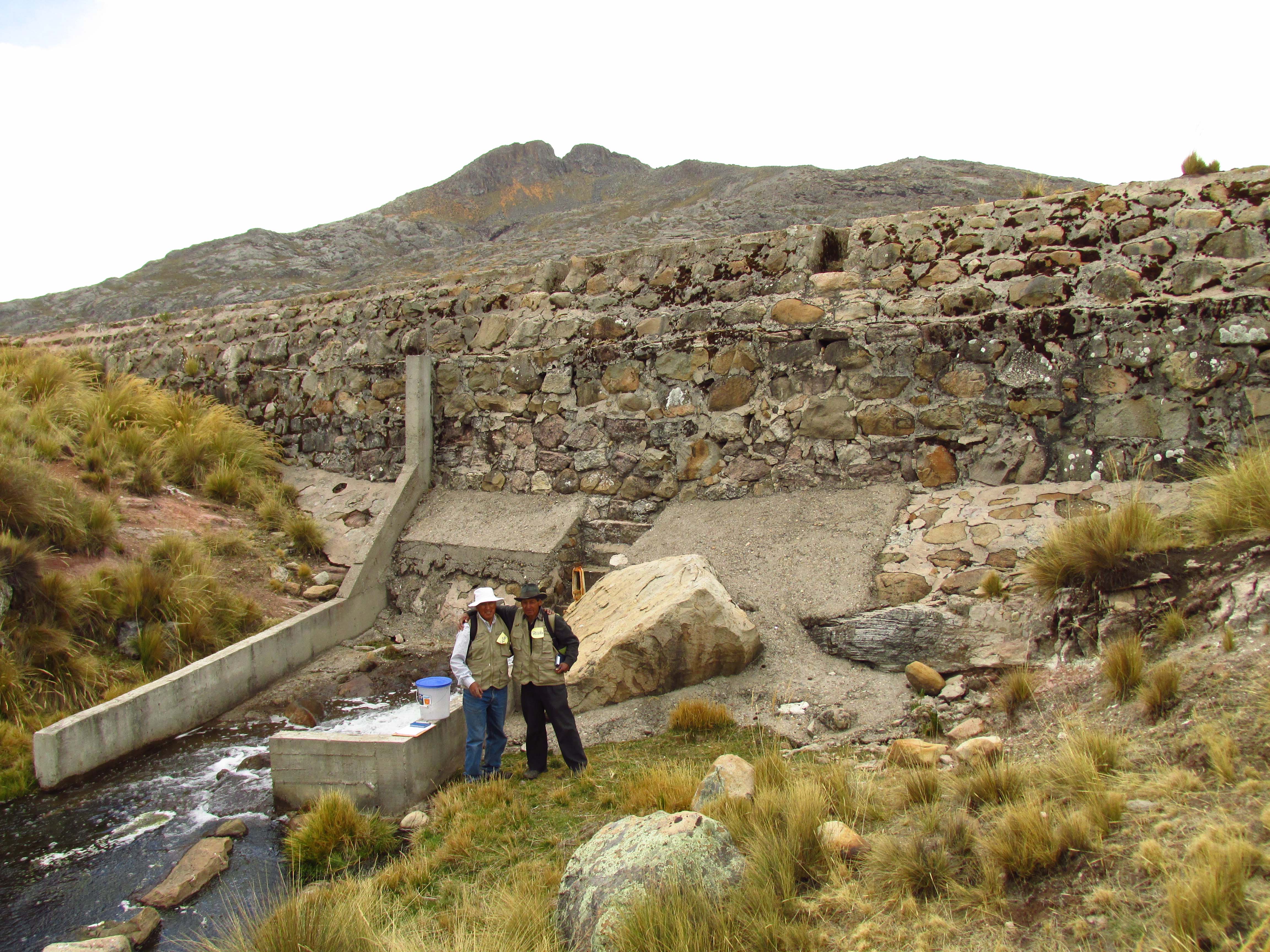
In the “Recovery of Technologies & Green-Gray Infrastructure” component, the Chacara dam was repaired and an old and unused water channel was rehabilitated. This allowed the recuperation of a network of ancient ditches in the communal farmland and in the high areas of Yanaututo and Pumapanca. These areas supply water to 560 ha of pasturelands (Hidroandes, 2015). In addition, the water is recharging temporary ponds and underground aquifers, that supply water to pits and springs in the lower part of the Jaramayo micro-catchment and the Cochas - Pachacayo sub-basin (Idem, 2015). A pilot area of 3 ha was fenced to protect pastures as they recover. It is monitored by the Landscape Reserve administration with support from the community. The community also contributed manpower to the activities in this component.

• Strong commitment from the community who contributed 45% of the cost through manpower, materials, equipment and machinery.

• Local researches linked the project with the communities.

• Commitment on the part of communal authorities.

• Sound relationship and coordinated work between the Mountain Institute and the Nor Yauyos-Cochas Landscape Reserve/ Peruvian Service of Natural Protected Areas (SERNANP).

• Steady support through a facilitator.

• Demand-oriented: The selection of measures should respond to local priorities and interests (being consistent with the EbA approach).

• Take into account the percentage of the population directly benefitting from (certain) ecosystem services as a selection criterion.

• Plan sufficient time for infrastructure measures, especially in areas of rugged topography and extreme climate, typical of high mountain areas, and in particular when local manpower/communal work is an integral part. Make sure the time required for the construction is in line with the timeline of the project.

• Reserve time for reflection during the implementation phase in order to take actions that enhance positive impacts.

• Seek commitment and support from local authorities/ leaders and involve them in key decision-making processes. Build partnerships with local governments, which will help to make the initiative sustainable.

Strengthening Local Skills and Knowledge

As part of the “Strengthening Local Skills and Knowledge” component, we conducted courses and workshops, facilitated discussion events, and led training on how to apply pasture recovery techniques and evaluate their effectiveness. These activities helped sensitize community farmers, inspiring them to create new, small projects such as fencing and recovery of pasturelands or water and livestock management. In addition, the monitoring system applied shows that skills for pasture management, with regard to evaluation, fencing and recovery at the family and community levels, have increased (IM, IUCN, 2015). As part of the communication activities, an informational showcase and two participatory videos, a theatre play and publications were produced. This contributed to raising awareness among the group of livestock farmers regarding pastures, water and livestock management and helped disseminate information about the project at community and landscape reserve levels (IM, IUCN, 2015). Information was generated through participatory rural diagnostics (specific studies in water, pasture, archaeology, social organization, productive activities) and a hydro-geological study in the water channel’s area of influence.

• Use of communication tools to increase local awareness and understanding of the project.

• Dialogue and knowledge exchange between local and external experts.

• Communication as a central component.

• Steady support through a facilitator.

• Local researchers served as a bridge between the project and the whole community.

• Plan communication activities as a cross-cutting issue of the project.

• Include activities that involve those groups within the community that may be underrepresented. For example, participatory videos, theatre plays and artistic activities are particularly suitable to convey messages to young people, women, children and elders.

• It is helpful to have a team trained in applying a participatory approach, using participatory tools and facilitating collective learning.

• Diversify methods with local partners, combining workshops with other, more practical and field-based ("learn-by-doing") methods and tools.

• Design and implement a communication strategy that helps to disseminate the intermediate achievements of the project. This might include communication tools of great appeal and impact, such as participatory videos and theatre plays or “Art Night".

• Maintain a high level of presence in the field and share everyday life with the community.
Strengthening of Community Organization

Under the component “Strengthening of Community Organization,” a management plan was developed to promote integrated management of pastures, water and livestock throughout the communal territory of Canchayllo. The goal was to strengthen community organization so that water could be distributed more effectively and grazing areas could benefit from improved rotation. The process to develop the management plan was facilitated by The Mountain Institute using a methodology to strengthen capacities, stimulating collective and social practices within the community. The plan is defined as a set of ideas that emerge from a given population by means of an in-depth process of analysis based on their own perspectives. The management plan can also serve as a tool for local management in the medium term.


According to the keen interest of this community, analysis and planning have focused on grasslands and water. The plan also encouraged the community to establish a committee to maintain and operate the renovated water infrastructure so that the water continues to flow and grasslands continue to be irrigated. In addition, a document with technical recommendations was developed for managing communal grasslands.

• Local and scientific knowledge exchange: participation and exchange among both local and external experts.

• Participatory approach and participatory action-research methodology.

• Commitment on the part of communal partners.

• Sound relationship and coordinated work between The Mountain Institute and the Nor Yauyos-Cochas Landscape Reserve/ Peruvian Service of Natural Protected Areas (SERNANP).

• Communication as a central component.

• Farmers’ interest.

• Steady support through a facilitator.

• A sound assessment of the social component is key in the diagnostic, including analyzing the current status but also past and present conflicts, as well as the tensions and tendencies. It’s also advisable to pay particular attention to existing activities incompatible with the EbA approach or other planned measures.

• Sufficient time is required to address the socio-economic, political and cultural dimensions in addition to the biophysical aspects (which often receive the most attention). Equally important are local governance, including mapping and analyzing past and present conflicts within the community, the direct dependence on ecosystem services and the type of management of the territory in the specific areas of the pre-selected measures.

• A good understanding of decision-making with regard to the management of resources in a specific area is key. This could be a community board, one or several families, an association within the community, etc.

Improvement of gray-green water and grassland management infrastructure

In the infrastructure component, the following actions were carried out:

  • expanding the fenced area of the Yanacancha wetland,
  • repairing the Yanacancha water pipeline: Curiuna to Huaquis segment.
  • sectorization (by fencing) from Curiuna to Tuntinia,
  • repairing and constructing five watering places (Curiuna, Wayacaña, Pampalpa, Colulume and Tuntinia), and
  • constructing a “water cave” at the entrance to Huaquis.

As we implemented this component, the community contributed their labor through communal tasks. The community was also responsible for transferring construction materials to this remote area.

  • Trust and good relationships were developed between the project team and the community.
  • Open, respectful communication as a central component.
  • Local interest, participation by the NYCL Reserve managers and commitment and support from communal authorities.
  • Solid relationship and effective coordination between The Mountain Institute, the NYCL Reserve managers and the national authority for protected areas (SERNANP).
  • During the planning phase, allocate sufficient time for critical activities such as working on infrastructure, monitoring impact, communications and systematization of results.
  • Local labor/ communal work for infrastructure development and/or maintenance might take more time than anticipated.
  • Seek commitment and support from local authorities and involve them in key decision-making processes. Build partnerships with local governments, to make the EbA measure more sustainable.
  • Present the EbA measure budget to the community and ask locals to contribute. Their contribution can be labor, expertise, equipment, materials and/or funds, etc.
  • Carefully analyze possible environmental and social impacts of the EbA measures and develop a strategy for mitigation and risk management.
  • Implement EbA measures with an adaptive management approach ("Not everything is done right from day 1"). In other words, plan to adapt as the project proceeds.
Stakeholder engagement and capacity development “on the run”

A shared understanding, engagement and commitment of key stakeholders and the availability of capacities and resources are key. Right from the start, climate change and the ecosystem services proved to be excellent topics to bring together expert opinions and different perspectives from stakeholders, enabling them to work together on common challenges.


An inter-secretarial workshop brought together representatives from different departments of the municipal government of Duque de Caxias. This (first) opportunity to exchange on these issues helped them to discuss the importance of considering climate change related risks in their municipal planning instruments. The participatory identification of climate change impacts fostered a common understanding of climate change as a crosscutting issue affecting all municipal sectors. The mix of inputs, discussions as well as working on the concrete case strengthened the spirit of cooperation and the search of synergies in preparing for (ecosystem-based) adaptation to climate change in the region of Duque de Caxias.


The final outcome was the creation of an inter-departmental working group on climate change, which seeks for coordination and cooperation in order to enhance adaptation success.

  • Strong ownership of the process on the part of the municipality.
  • Awareness of the need to improve the planning procedure and willingness to implement the necessary steps.
  • Reduction of frontal input during workshops to a minimum, giving to participants as much ownership of the process as possible, and therefore enabling them to discuss and learn “by doing”.
  • Climate change and the ecosystem services approach proved to be excellent topics to bring together experts and stakeholders with different visions, enabling them to collaborate on common challenges.
  • Introducing vulnerability to climate change and ecosystem services as crosscutting issues, rather than separate topics, increased the likelihood for them to be considered a topic of high-value.
  • The combination of workshops with capacity development elements helped to sensitize representatives from different sectors for the need to cooperate and coordinate in order to reduce specific risks.
  • The joint development of starting points and concrete steps to consider vulnerability to climate change and ecosystem services in planning processes lowers the stress of local planning teams.
Mapping of key ecosystem services

The aim of this step was the mapping and evaluation of ecosystem services (ES) provided by the region’s ecosystems, using the IES approach (Integrating Ecosystem Services into Development Planning).


The first step of the workshop was a participative selection of the most relevant ES, so that they can be considered in spatial planning processes. In a second step, using the Matrix Method, the following activities where undertaken for the mapping of the ES:


  1. Creation of a database (current land-use, present and future conditions of ES), design of interview guidelines.
  2. Mapping of relevant interviewees (specialists, decision makers and community representatives), carrying out of the interviews.
  3. Creation of the ES Maps using GIS/QGIS. The maps show the location and intensity of the ES and the main drivers leading to degradation of ecosystems.

The analysis identified conflicts between zones of the current master plan and some of the landscapes that provide important ES. Additionally, several patches of native vegetation inside urban areas have been identified as suppliers of ES, which provided new information for urban planning. The mapping also generated data with explicit information regarding cultural services for the first time.  

  • Municipal technicians’ recognition of both, the importance of ES for the population’s well-being, and the fundamental significance of the protection of ecosystems for the municipality is key for this step.
  • Based on this enabling factor, they facilitated as many resources as possible for a smooth implementation of the work. As a result, the ecosystem services mapping played a key role for a solid diagnosis that allows considering ecosystem services in territorial planning.
  • The ES assessment was an opportunity to: (1) increase public participation in territorial planning; (2) systematize and make use of local knowledge; (3) increase general acceptance of the future zoning proposal; (4) clarify and explicit land use conflicts and uses/dependencies of ecosystems; and (5) add valuable information to the territorial diagnostic in a language that allows for a good understanding of all sectors of the government regarding the importance of each ecosystem.
  • Including key stakeholders in the mapping is vital, both to increase legitimization of the data and its acceptance and to ensure the stakeholders’ advocacy for the results. Validating each step with stakeholders is crucial both to ensure ownership of the results and to enable them to understand and advocate for the results.
  • Necessity of carrying out a detailed stakeholder mapping to identify all key stakeholder as well as of spending more time on this preliminary selection and interview process.
Organizational Development and Capacity-building

There are several critical organizations within communities that need to be developed or strengthened in order to ensure long-term success of the fisheries management. Campaigns must ensure that the fishery councils, the management bodies, and the fisher associations are organized and well-functioning. They are trained on topics like adaptive fisheries management, management essentials, volunteer management, and team building.

To implement a shared management system, each RESEX has its own deliberative council, a management body of community-elected members, representing and voting on behalf of the community. Rare works directly with this group to improve the decision-making process at a community level. Rare’s local implementation partners are small associations with strong connections to the community. They are able to effectively manage funds and participate directly in the campaign project designs.

Engaging the management body in definng the campaigns' goals, was a key milestone for Fish Forever campaigns. When these groups understood and supported Rare’s strategies, they were more willing to support the implementation of no-take zones and other sustainable fisheries management practices, like ACRES. Campaigns and capacity-building trainings also empowered these groups to share knowledge and positive experiences to other MPAs and management bodies in Brazil, through national fisheries organizations, who also supported in the replication and scaling of the next Fish Forever cohort.

Community Engagement & Behavior Change

The behaviour change campaign team at each municipality uses a mix of creative materials and community mobilization activities to inspire and educate fishers and their families about the benefits of working together to manage their fisheries better.  In the ‘Readiness’ phase, the messages are focused on getting fishers to become registered fishers, complying with basic fishing laws, and participate in meetings. In the second phase, after the managed access areas are institutionalized, the messages focus on building compliance for the rules and monitoring of their catch.  Through social marketing, Fish Forever can more easily earn buy-in from communities to follow best practices for fishing and encourage new solution innovations from communities for sustainable fisheries management.

A strong sense of place and identity among fishers in communities and active support of municipal and village leaders, combined with motivated and efficient Fish Forever and Rare staff, has enabled sites in Brazil to replicated their success in other regions.

Many commonalities exist between sites, so campaigns were able to use and adapt materials from other municipalities also focusing on fisheries management. Local adaptation, especially of mobilization activities, helped to make the campaigns more site-specific and ‘ownable’ by the community.

Participatory Managed Access Design & Implementation

Using the data from profiling, fishers and community leaders are engaged over a series of workshops that guide them through a) defining their community goals in relation to fisheries and conservation, b) evaluating their reserves, c) delineating areas for managed access, and d) agreeing on the rules within their managed access areas.  Once these have been agreed on, they are codified in policy, and institutional arrangements are put into place for implementation.

Through behavior change campaigns, Fish Forever is increasing the productivity of management bodies. These bodies are then planning and approving new laws and roles for fisheries that will positively impact the community.

The buy-in of the Brazilian government through RESEX management bodies and a pre-existing legal structure for managed access for fishers, paved the way for the campaign and managed access + reserve implementation.

Inputs from the first stage on were critical to build trust.  It is important that all discussions and agreements during the workshops are shared with communities and consultation sessions are held, before proceeding to the next stage of the design process.

Understanding People and Context

Qualitative and quantitative research is conducted to produce profiles of both the fisheries and the fishers. Final decision for implementation sites and institutional partners for Brazil's first cohort were based on:


1) site fit (suitable ecological, fisheries, and social dynamics);

2) potential for strengthening the implementation of TURFs (=Territorial Use Rights for Fishing) and creation and implementation of no-take zones;

3) regional experience and lessons learned;

4) funding opportunities;

5) government (ICMBio) and partner priorities as opportunity for scaling; and,

6) analysis of potential threats to developing a TURF-Reserve (such as upstream dams, pollution, etc.).

This process is also instrumental to develop partnerships with local associations and leadership to approve the implementation of the campaigns in all sites.

The Brazil RESEX (=extractive coastal and marine reserves) framework offers a favorable set-up to implement TURF-Reserves. While there are differences in governance between local communities’ approach and that of the National Government (ICMBio), we believe there is a great opportunity for collaborating in improving the management of MPAs in Brazil. Additional policy work and advocacy are crucially needed as part of Brazil's country strategy in order to secure fisheries access rights.

  • Fish Forever sites are carefully selected for potential impact. We learned from site selection that each site has a set of conditions that can enable success. We incorporated this lesson learned into the cohort selection process. Furthermore, some less-than-ideal sites will allow us to learn how to work across a wider range of sites.
  • The chance to manage and ‘own’ their fisheries is a powerful benefit for fihsers, but biophysical and economic returns will also need to be estimated in order to motivate further communities.
  • Related to the theme and the cohort objectives, a Pride+ strategy would be applied as the behavior change intervention strategy. Pride will address the expanded need beyond a social marketing approach, to also include other techniques, such as community mobilization, group-dynamic strategy, early on in order to create an enabling environment for the TURFs.