Developing a honey export value chain

Honey export value chains have been developed according to the following stepwise approach:

  1. Selection of cooperatives
  2. Training model farmers in pre-and post-harvesting quality management, organic certification and internal controlling system, traceability system to fulfill EU-quality parameters
  3. Provision of food grade and quality improving equipment (packaging & processing equipment, solar lamps, food grade honey bags, presses etc.)
  4. Provide technical expertise from Germany to smallholders, their cooperatives and unions in honey processing and fulfilling the export requirements (e.g. honey water content control)
  5. Support the unions to acquire an export license, organic certificate and risk management certificate plus other necessary requirements from the Ethiopian government in order to implement the export process
  6. Communication to veterinarians and other inspection authorities on EU-level by German partners to allow future import of Ethiopian honey
  7. Constantly monitor and guide honey unions, laboratories and authorities during the export procedure
  8. Establish a contact to the shipping line by German partners and prepare honey export logistics
  • Trust between local farmer unions and international companies and advisors
  • Clear demand for high quality honey by business sector in Germany
  • Higher demand for organic honey in Europe due to lower export rates from Latin America & Asia as honey production is increasingly meeting domestic demands
  • Use restrictions of BR buffer zones according to UNESCO
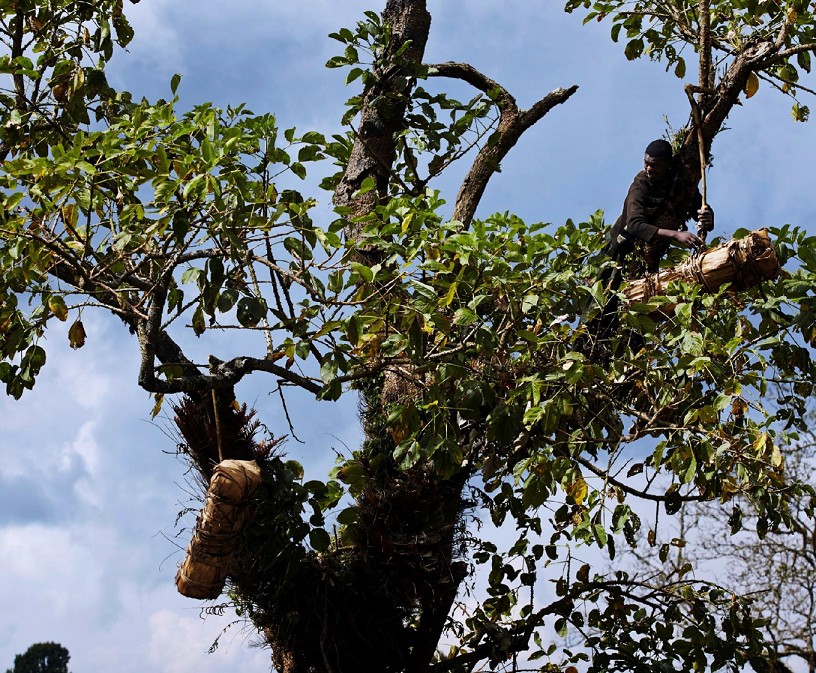
  • Local smallholders engaged in participatory forest management (PFM) groups receive official forest user rights & direct access to products
  • The interplay between local expertise and international know how resulted in a successful set up of value chains. It was crucial to conduct very detailed trainings with producers especially on post-processing to achieve high quality honey
  • Local prices for honey are high which made the price negotiations difficult for the international buyer
  • The ownership of the whole “value-chain” from the grass root producer up to the loading the coffee bags onto a vessel for the overseas market is owned by the producers and their representative umbrella structures. This is a unique example where grass roots structures have become global business partners 
  • Meeting the EU quality standards needs constant checks of honey producing methods. Producers mostly achieved fulfilling the quality standards and delivered 42 Mt of honey. The rest of the honey has been sold to local traders for the local market or other purposes resulting in additional but lower revenues as exported honey
Developing a wild coffee value chain

The business model is based on trading, value adding and promoting specialty wild coffee on the European market, which is handpicked from the original coffee forests. Value chain development involved the following steps:

  1. Build up and strengthen collaboration with local farmers
  2. Identification of suitable collection areas based on resource availability, forest coffee conservation needs & accessibility. 
  3. Training on a) harvesting (picking + separation); b) post harvest handling (separation, drying, sorting and spreading on drying beds
  4. Training on the use of central drying station on cooperative level, site selection and training on the setting up of raised beds
  5. Training on certification requirements (organic wild collection and fair trade certifications) and setup of an internal control system
  6. Advise and support cooperatives and unions to fulfil certification standards
  • Clear demand for high quality wild coffee by consumers and business sector
  • Growing demand of specialty coffee approaching 10% of world consumption, gaining market share rapidly
  • Reliable partnership between unions and Orignal Food
  • Successful examples of strong and exporting coffee trade unions in Ethiopia bringing benefits to their members
  • Use restrictions of BR buffer zones according to UNESCO
  • Local smallholders engaged in PFM groups receive official user rights over the forest areas & direct access to forest products
  • Limited finance sources are the major problem for producing and exporting higher quantities of wild coffee. Local banks are limited in giving loans to unions and producers.
  • Using central drying stations allows successful separation of wild forest coffee from semi-forest and garden coffee and a considerable quality improvement
  • The whole value-chain is owned by producers and their umbrella structures. This is a unique example where grass roots organizations have become global business partners 
  • More and more smallholders are involved in the trade and the export volume of certified wild coffee keeps increasing;
Importance of conservation

Scientists, who have been monitoring the area before it was closed, estimate a 500% increase in biomass within the area since the closure. The area, previously covered with sea urchins, is now a thriving biodiversity hotspot with the balance restored. The elders report new species in the MPA that have not been seen in living memory. The coral, previously destroyed by human feet, has recovered quickly and the lagoon area is now known as one of the best snorkelling destinations on the Kenyan coast. Local and international students come and learn in our living marine classroom. Turtles feed on the seagrass beds undisturbed, and the number of nests has increased significantly. The area has returned from being a marine desert to a marine paradise and a critical model globally that shows how a poor community can help conserve nature and benefit from it too. Bigger and better catches outside the MPA has ensured support for the permanent closure.


The MPA could not have gone a head without the belief and forsight of the fisherfolk in the area and the acceptance to beleive that positive change was possible even in difficult circumstances. Local knowledge from the elders ensured a suitable site for the closure was chosen. Scientific research also supported the choice as having the most potential for long term improvement. Regular updates on improvements within the MPA has helped sure up the belief that it is successful as a breeding area.

That nature is resilient and can recover amazingly quickly if left alone to do so. Identifying needs and fostering willingness to embrace change can improve livelihoods. The importance of undertaking an environmental impact assessment on the area, underpinned by research and local knowledge, before the project started has been a critical factor towards the success of the MPA. Constant awareness and updates of the improvement in the MPA need to be communicated back to the community. Analysing the information can be used to put into perspective in the socio-economic impact. The importance of communication of our progress back to the community has been something we have had to improve. When the community understands and sees the benefits from change they are, understandably, more willing to accept it.

Community welfare

Although the MPA quickly recovered and livelihoods began to improve part of the management plan was to introduce other non-fishing based enterprises in an attempt to achieve a self-sustainable solution. Initially, outside funding had to be sourced to enable this to happen, and various grants were forthcoming. Initially, a tourism business taking advantage of the improvement of coral and biodiversity within the MPA attracted visitors. This produced training opportunities, created steady employment to fishers improving their livelihood and taking pressure off the marine resource. The youth were trained in furniture making from old dhows, honey was produced, sustainably caught fish sold to restaurants, vegetables and crops grown and sold, various aquaculture projects are underway, and the women group have various enterprises including tailoring and a craft shop selling products made from driftwood and natural soaps. A loan scheme allows the members to finance other projects. A portion of the profit goes towards community welfare needs like water, health and sanitation. Beach waste is collected and sold to recycling companies. A school education programme educates the children on the importance of sustainable use of resources, and we provide trips within the MPA. 

The MPA is the heart of our project. The protected breeding ground means improves fishing in the area with a knock-on effect of improved livelihoods. The MPA has become an attraction and visitors bring in much needed funds which go towards employment, training, the running of the organisation and setting up other businesses. While we faced challenges and objection to setting aside the area of the MPA, the results have shown it was worth it.

For conservation to work it needs to be accompanied by tangible alternative opportunities and real improvements in livelihoods. The resource that is being conserved needs to be valuable and important to the local community. All the components have to work in unison and benefit the community. Whilst an LMMA takes time, understanding and patience to set up and establish, it becomes an efficient and productive hub from which other projects can grow. It has multifaceted benefits that can cover both conservation and community welfare. We learned along the way that there is no short cut to community buy-in. In our case, we were working with a subsistence community and even short-term threats to their livelihood meant direct hardship that led to resistance. We learnt that most of the resistance we met was underpinned by a real fear of economic insecurity. Once we understood that the needs of the community were paramount, we could devise relevant and impactful strategies to achieve our conservation goals.

Marine protected area (MPA)

Community recognition that action was needed to improve dwindling fish stocks was followed by the identification of various stakeholders to help us achieve our goals. Communication, outreach and awareness building programmes were set up and a visit to a similar project in Tanzania went ahead in 2004, and encouraged the community to use local marine resources sustainably.


A democratic decision to close an agreed lagoon area was agreed. Legal and policy frameworks were put in place, and the first LMMA in Kenya was approved in 2006 under the National Environmental Management Authority. Following this, a collaborative governance model has emerged under Beach Management Units (BMU's), where fishers and government work together towards sustainable fishing and improved livelihoods. In setting up the MPA, we went through various phases; conceptualisation; inception; implementation; monitoring; management and ongoing adaptive management.


The realisation by the community that there was a significant crisis looming and a determination to act for the sake of future generations was a crucial factor in the implementation process. Trust and belief in a positive outcome was paramount. Initial funding for alternative enterprises and support from key partners was necessary for technical and advisory capacities. An area was chosen that had good recovery potential with help from a scientist that had previously been monitoring that part of the coast coupled with local knowledge.

From the outset a clear strategy and management plan devised with maximum participation from community members is critical. Listening to the elders within the community creates an essential link between past and present. Targets and goals need to be achievable and clear timelines need to be set and adhered to keep the support of the community. The entire community needs to benefit from the project, and livelihoods need to improve tangibly in order to maintain support and create a sense of ownership that gives the project longevity. A community welfare aspect should be part of the strategy. Awareness, education and sharing of information need to be maintained, and a willingness to an adaptive management approach is vital. Learning from mistakes, sharing knowledge and creating close alliances with other similar organisations helps the project progress quickly. Creating collaborative partnerships and following clear procedures and legislative guidelines strengthen the structure of any entity. Good governance from the outset with a clear constitution that is followed at all times. 
Community based action plans

Relevant stakeholders are engaged to identify challenges within their respective communities and solutions that are ecosystem friendly but contribute to the enhancement of local livelihoods. This process follows a prior participatory community-wide assessment and validation of results from the assessment or survey process. The assessment identifies livelihood and climatic trends and impacts on various sectors. Following this, a stakeholder meeting is initiated through which potential adaptation and sustainable livelihood stategies are proposed and adopted against each challenge and included in the overal community-based adaptation plan. A community-based action plan matrix is then generated through the stakeholder participatory process that includes the following sections: livelihood and adaptation options, duration of implementation, actors, required resources, key expected results and estimated amount to implement each adopted strategy or action.

  • Availability of adequate data or information collected through a participatory process using participatory instruments involving various stakeholders.
  • Participatory involvement of both local and County-level stakeholders


  • Adequate involvement of stakeholders including community members can help collect data on baseline information.
  • Community involvement from the beginning contributes to them accepting management planning results and their positive contribution towards implementation.
  • Sharing the community based plan with local stakeholders and community members contribute to their ownership of the local-elevl generated action plans.
Community exchange visits

Exchange visits were organized to places where the initiative has been active for some time and the implementation is on-going. For example, in order to acquire drought tolerant crops for local production, Ecofinder Kenya visited the Tangokona community in Busia County, Kenya where improved cassava and sweet potato varieties have been promoted and grown by local communities. The model was studied by Yala wetland communities, seeds purchased and farmers are now growing drought tolerant cassava and sweet potatoes.

  • Pay actual visit to model sites or farmers.
  • Availability of resources including transportation, learning facilitation at the place of visit.
  • Willingness to learn and practice the new skills among the interested stakeholders.
  • Local production of recommended drought resilient crop varieties can be achieved by learning and sharing of skills and ideas.
  • Farmers can embrace and practice what they see and can confirm to have worked in similar places.
  • The success of implementation of improved crop production and testing of new crop varieties may be dependent on prevaining weather conditions mainly rainfall amounts especially for rain-fed agriculture.


Stakeholders involvement and participation

This involves participation of all stakeholders at the local level in order to come up with locally viable solutions that all participants are comfortable with and that contribute to sustainable livelihoods and long term conservation of local biodiversity. We achieved this building block by involving stakeholders at different levels, i.e. at the meso or County level and micro or local community level. First, we engaged representatives of the Siaya County government departments  (such as Agriculture, Lands, Tourism, Environment and Natural Resources) and Civil society representatives working at the local and regional levels. A workshop was organised upon which the government and non-government actors discussed the challenges facing agriculture and biodiversity in relation to climate chage in the County and amicable and potential solutions sought from the participants. Secondly, local level meetings were held with community members and local leaders and resource persons including elders, retired government staff, health workers and conservation enthusiasts. The challenges facing agriculture and local biodiversity were sought and potential solutions reached. These were then analysed to come up with overal challenges and solutions from the stakeholders perspective.

  • Analysis and involvement of critical stakeholders to make sure that all people with interest are involved. This should include (1) government departments at the County or District levels, (2) Non-state actors including Non-governmental Organisations (NGOs), Community-based Organisations (CBOs) and Faith-based Organisations (FBOs) among others, and local communities
  • Recognition of the roles played by various stakeholders.
  • Recognition of potential benefits and benefit sharing from the proceeds of conservation.


  • Stakeholder involvement at both meso or County/District level and micro/community level ensures potential for inclusion and use of results in local policy change
  • Forums bringing government and non-state actors contribute to harmonisation of conflicting views and ideas and ensure potential for harmony in implementation of various strategies. However, we experienced many opposing views during strategy discussions pitting the government officers and the civil society.
  • Potential for benefit sharing and incentives are critical for conservation of biodiversity at the local scale.
  • Local communities are willing to participate in biodiversity conservation initiatives when alternative livelihoods can be provided.


Implementation of a GPS navigation system

During this survey, the Nature Reserve's launch was made available to study the shallow coastal waters. With a length of 8 meters
equipped with sounder, GPS and radar. To complement this equipment and obtain the finest possible accuracy, the launch was equipped with a differential GPS operating in real-time WAAS/EGNOS metric mode, with an accuracy of the order of 1 to 2 meters. An RTK (Real Time Kinematic) system was used for greater precision during the investigations. Its beacon was placed on the roof of the Cap Béar semaphore, close to the survey area. This is a method whereby GPS signal corrections are transmitted in real time from a reference receiver, located at a precise known point, to the boat's mobile receiver. Accuracy can then be
centimeters if you are close to the reference receiver.

It is essential to identify the partners who can meet the objectives set by the manager. Appropriate resources and local knowledge are also essential to avoid wasting time. Regular exchanges with the partners involved in the project will help to obtain answers and anticipate problems.

It is essential to define very precise specifications so that the monitoring meets the expectations of the service provider, but also so that the use of these new technologies does not distort the comparison with the results obtained during previous monitoring.

Use of side-scan sonar to map seagrass beds in the Cerbère-Banyuls Marine Nature Reserve

For several years now, numerous studies have been carried out on Posidonia meadows in the Reserve. Each study provided increasingly accurate results, but left a number of gaps. The Reserve decided to fill these gaps by simultaneously using several innovative systems, such as side scan sonar (SBL). This sonar provided an overview of the characteristics of the seabed. The integration of Acoustic Systems for Automatic Bottom Classification (SACLAF) data from previous missions into this project will have been a complementary means to the acoustic scanning imaging system, providing an element of data validity. The reliability of the results was assessed using GoPro® cameras. All data were processed using ArcGIS version 10.3 geographic data processing software.

Acoustic data were acquired using a C-MAX CM2 EDF side scan sonar and processed using Hypack 2012 software. In order to obtain the expected results, i.e. precise mapping of the Reserve's seagrass beds and a comparison of the evolution of the seagrass beds in relation to the last surveys, perfect knowledge of this equipment and of the study area is required.

- Regular exchange and sharing with service providers

- Competence of equipment users

- Ability to process data

- Realization of ground truth