The Key Processes in Integrating Mangrove Conservation into National Policy

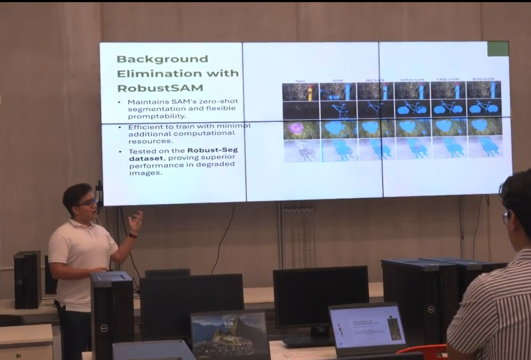
The process was the cornerstone for transforming ideas into tangible results. The first step was ensuring the availability of high-quality data and demonstrating its importance within both local and national contexts. In the case of mangroves, this included their role in spatial and development planning, included in the National Territorial Development Plan, which highlights their impact on coastal livelihoods, climate adaptation, and potential blue carbon credits.

Once the data was gathered, the next step was presenting it to IUCN’s partners and members, fostering a supportive alliance to create a unified voice for advocating with decision-makers. This process continued by establishing and maintaining an open, trustworthy, and technically robust dialogue with policymakers and their technical teams. A key component of this was understanding how governance, policy and legal frameworks are developed and implemented, ensuring that even if contributions weren’t fully aligned with initial expectations, they remained practical and applicable and are adopted.

Ongoing monitoring, along with continued support from IUCN, ensured that the strategies were effectively implemented and adjusted when necessary. It’s important to acknowledge that while conservation and adaptation efforts are globally supported, they often require significant budgets, that are not available locally. To secure funding, these issues must be at the forefront of governance planning, allowing for the budgets and co-financing by development partners to be available.

Critical factors that facilitated the process included the global campaign of raising awareness about the benefits of mangroves for sustainable livelihoods, Mozambique’s focus on the mangrove strategy, and the development of key national policies like the PNDT and Marine Spatial Plan. IUCN’s commitment and its ability to identify opportunities to mainstream mangroves within these national strategies, coupled with its extensive network and reliability, were equally essential.

Several lessons emerged throughout this process. First, technical assistance, similar to that provided to the government proved invaluable, as did the capacity to step up in alignment with government processes. The ability to access upgraded technical support when required, and the involvement of academia and civil society organisations, are critical for a successful approach. Maintaining ongoing information-sharing and an awareness campaign, combined with consultations, helped sustain engagement throughout the process.

The Power of Knowledge about Mangroves in Shaping Conservation and Policy

The vital role of mangroves in coastal ecosystems has been emphasised through a wealth of scientific data and research. This knowledge has become the entry point for educating planners and decision-makers on the socio-economic significance of mangroves, from providing community income to supporting coastal adaptation. Through studies conducted by SOMN on Mozambique’s mangrove use and data from the Global Mangrove Alliance, IUCN has united key conservation actors such as WWF, WCS, Centro Terra Viva, BIOFUND, ABIODES, and government institutions to establish a common voice in advocating for mangrove protection.

IUCN and SOMN played a pivotal role in the elaboration and approval of the National Mangrove Strategy, which outlined clear goals, approaches, and restoration principles and were endorsed by the Government and conservation partners. Building on this foundation, the strategy was integrated into national policies, particularly the National Territorial Development Plan. This plan not only drives sustainable development but also maps out Mozambique's rich biodiversity, including its mangrove ecosystems. This allows local governments and community leaders to identify key conservation hotspots and priority restoration areas. The strategy also provides geographical and quantitative data, enabling conservationists and NGOs to monitor and track progress in their interventions.

Key for these activities were the existing data and studies, IUCN's broad network of members and partners, and the trust and credibility IUCN has built with policymakers.

While the knowledge was foundational, its true potential was realized through effective processes and strong partnerships. IUCN's acceptance by the government and its partners was quintessential to ensure engagement and ownership at every stage of the process. It was also vital to ensure the quality and availability of data, and to collaborate closely with the government to adapt and incorporate recommendations into the legal framework, ensuring that mangrove conservation became a long-term priority.

Delopment of the SIREN App

This building block is to explain how I developped an App that allow fishers to contribute to marine science knowledge in Africa. 

Initially we gave fishers a pre-printed form to report opportunistic sightings they encountered. However, the form was getting lost most of the time. 

We decided to move to a digital solution. The existing App by then required internet to work and was just too complicated for fishers. So we thought we shoud develop an App that will be more userfriendly for fishers. 

We wrote the  algorithm (workflow) of the App and then contracted an Indian development company to write the code. 

Later we had to bring the development of SIREN back to Cameroon to reduce the cost of developement. 

We work with volunteer around the world that will continuously support with the development of the SIREN

  • passion and determination
  • availability of seed fund to develop an initial version of the SIREN App
  • Collaboration with local App developpers
  • Extending the collaboration to international volunteers 
  • understand
  • The first developper company I contracted for the development of SIREN was a foreign company based in India. The cost of develpment was very high and there was a lot of miscomunication due to language barriers. When we started working with local developpers, the cost of development decreased importantly and it was easier to communicate.
  • Before giving a smarphone to fisher for data collection you must develop a trust relationship with him before otherwise the phone will never be used by the fisher to report sightings.
SMART Technology for Monitoring and Surveillance

The second block incorporates technology adapted to the local context to improve biodiversity monitoring and surveillance. Basic telephone equipment is used together with the SMART application, an innovative tool that allows data to be recorded, analyzed and prioritized without the need for an internet connection. Community guardians are trained to operate this tool, collecting key information on the status of guanaco populations and threats such as poaching. This approach combines accessible technology with community leadership, promoting evidence-based conservation and optimizing resources. The simplicity and effectiveness of this block make it replicable in other territories with limited resources and similar conservation challenges.

In addition to the assessment of vertebrate biodiversity, the DNA of the species is carried out in order to improve the species' condition. The SMART, camera traps and DNA are integrated into the protected area's integrated participatory monitoring system. The DNA is from the species, which is collected from its feces. To carry out the population assessment. The community guardians collect the samples and are trained to collect the samples.

  • Technological Accessibility: Use of simple telephone equipment, compatible with the SMART application, adapted to the rural context (https://smartconservationtools.org/en-us/).
  • Technical Training: Practical training of community guardians to use the tool effectively.
  • System Adaptability: SMART works without the need for internet connection, an advantage in remote areas such as Alto Isoso.
  • Evidence-Based Data Collection: The application allows prioritization of conservation actions based on concrete information.
  • Institutional Support: Fundación Natura Bolivia provides tools and training, facilitating the implementation and sustainability of this technology.

Accessible technology, such as SMART, combined with training, allows local communities to collect valuable data for conservation. Tools adapted to the rural context are effective and replicable. Institutional support is crucial to ensure sustainability and strengthen evidence-based decision making, improving biodiversity monitoring.

Guarani roots and wisdom

This approach reinforces cultural identity, empowers local stakeholders as guardians of their territory and establishes effective governance based on respect for the environment and community decisions. This model is adaptable to other protected areas where the active participation of local communities is key to sustainability.

The Guaraní have lived with nature for hundreds of years. Monitoring makes it possible to maintain and revalue the local knowledge of the Guaraní population.

  • Traditional Knowledge: The integration of Guaraní ancestral knowledge with modern management approaches strengthens the cultural connection and understanding of the territory.
  • Cultural Identity: Pride in their Guaraní heritage motivates communities to lead the conservation of their territory.

The active participation of communities and the integration of traditional knowledge strengthen territorial management. Participatory processes reinforce cultural identity and ensure inclusive decisions. Training local leaders empowers communities and demonstrates that knowledge-based governance is key to sustainability.

Capacity Development through Technology Training

This building block emphasizes the importance of training students and local actors in advanced technologies for conservation purposes. In Bio-Scanner, students from the Universidad Politécnica de Yucatán  are trained in using AI algorithms, camera-trap data processing, and decision-support tools, fostering a new generation of professionals equipped to address biodiversity challenges.

The purpose of this building block is to build local capacity by providing hands-on training in cutting-edge technologies. This ensures that local actors can independently use, maintain, and replicate the solution in other contexts while fostering professional development among students.

Enabling factors:

  • Access to training resources and mentoring from experts in AI and conservation.
  • Collaboration with academic institutions to recruit and support students in applying their skills to real-world projects.
  • Ongoing support and capacity-building to ensure trainees can effectively use the tools and scale their applications.
  • Practical, hands-on training is more effective than theoretical approaches in building capacity for conservation technologies.
  • Partnerships with academic institutions provide a sustainable pipeline of trained professionals for long-term conservation efforts.
  • Regular follow-up and support after training help trainees apply their skills effectively and adapt to challenges.
  • Integral overview of the project, helps trainees to gain an overall vision of the entire initiative and notice the impact of their work in the project.
Advanced Image Recognition Algorithms for Jaguar Monitoring

This building block is centered on the use of Convolutional Neural Networks (CNNs), including Siamese and Autoencoder architectures, to detect and identify individual jaguars based on unique features such as rosette patterns and morphology. These algorithms process camera-trap data efficiently, reducing the time required for analysis and providing critical insights for decision-making in conservation.

The purpose of this building block is to enhance the monitoring and understanding of jaguar populations by automating the identification process. The algorithms detect jaguars in camera-trap images and classify individuals, contributing to understanding population size, distribution patterns, and behaviors. This facilitates conservation planning and policy-making by decision-makers. Additionally, the models are scalable and can be adapted to other species and ecosystems, expanding their applicability beyond the Yucatán Peninsula.

Enabling factors:

  • Availability of high-quality camera-trap data for training and validating the algorithms.
  • Technical expertise in AI and machine learning for developing and fine-tuning models.
  • Collaborative partnerships with local institutions for field data collection and algorithm design, development and testing.
  • Access to sufficient computational resources to train and deploy the algorithms effectively.
  • High-quality and diverse datasets are critical for achieving accurate and reliable results.
  • Community and academic involvement, such as the participation of the Dzilam de Bravo community and the Universidad Politécninca de Yucatán, enhances project outcomes by ensuring local capacity and ownership, and technological expertise to design the necessary algorithms.
  • Explainability in AI models (e.g., through Gradient Cam) is essential to build trust and ensure the results are accessible to decision-makers.
Spatial Intelligence for Wildfire Management

This building block provides the essential spatial intelligence for PyroSense, enabling a dynamic understanding of the geographical landscape. Its core purpose is to identify fire risk areas, pinpoint incident locations, and visualize resource deployment. This is crucial for strategic decision-making, allowing proactive resource allocation, and response planning. 

PyroSense utilizes a robust Geographic Information System (GIS) to power this function. The GIS integrates various spatial data layers, including topography, vegetation, infrastructure, etc. Initially, baseline risk maps are created by analyzing factors, guiding the placement of sensors and cameras.

Upon detection of a potential fire by environmental sensors or AI, the system immediately feeds the precise coordinates into the GIS. This real-time location data, combined with meteorological data (local and satellite), enables dynamic risk assessments. The GIS also serves as a central operational dashboard, visualizing the real-time positions of all deployed assets, including drones and first responder teams. This facilitates optimal resource allocation and coordination. This critical information is then communicated via a web application to stakeholders, providing clear visual situational awareness and supporting informed decision-making. 

  • Accurate and Up-to-Date GIS Data: Access to current geospatial data on topography, vegetation,  historical fire activity is essential for reliable risk assessments.
  • A powerful GIS platform is necessary for integrating diverse data layers, performing complex analyses, and running real-time AI.
  • Expertise is needed to interpret GIS data, validate models, and use the platform for strategic planning and incident management.
  • Connectivity with environmental sensors, drone feeds, and meteorological data is crucial for dynamic risk mapping and accurate fire tracking.

The accuracy and utility of geospatial planning are directly proportional to the quality and timeliness of the underlying GIS data. Investing in high-resolution, frequently updated maps and environmental data is paramount. Furthermore, the ability to integrate real-time sensor and drone data into the GIS for dynamic risk assessment proved to be a game-changer, moving beyond static planning to predictive capabilities. 

Initial challenges included the significant effort required to collect and digitize comprehensive baseline GIS data for large, remote areas. Data standardization across different sources (e.g., various government agencies, local surveys) was also a hurdle. Additionally, ensuring the GIS platform could handle the computational load of real-time data fusion and complex fire spread simulations without latency issues was a technical challenge.

  • Before deployment, dedicate substantial resources to acquiring and standardizing all relevant geospatial data. 
  • Choose a GIS platform that can scale with increasing data volumes and computational demands.
  • Ensure that local teams are proficient in using the GIS platform  
Comprehensive Data Ingestion for Fire Detection

This is the comprehensive intake mechanism for all information vital to PyroSense's platform. Its purpose is to gather real-time data, from multiple origins, ensuring the system has the input needed for accurate analysis and effective decision-making. 

PyroSense integrates an agnostic and highly compatible array of data:

  1. Environmental IoT Sensors are strategically deployed, and continuously collect real-time CO2, temp. and humidity data. They are agnostic in type and protocol, compatible with MQTT, LoRa, Sigfox, and NBIoT, ensuring broad integration. For efficiency, they feature long-lasting batteries (up to 10 years), minimising maintenance.  

  2. Fixed cameras and drones capture high-resolution images and live video. Integrated Vision AI processes this visual data in real-time to detect anomalies like smoke or fire. 

  3. PyroSense gathers data from local weather stations and satellites. Combining granular local data with broad satellite coverage provides a comprehensive understanding of current weather.

  4. GIS provides foundational spatial information, including maps of terrain, vegetation,  infrastructure, etc. 

  5. Firemen Wearables monitor real-time biometrics. AI enhances data for risk pattern recognition, of fatigue or heat stress. Real-time alerts are sent to nearby teams or control centers, enabling proactive intervention.

  • Reliable Sensor Deployment: Sensors should be strategically placed, well-installed, ensuring continuous data collection and security.
  • Data Stream Integration: Integrating data from various sensors, cameras, drones, and meteorological sources is crucial for situational awareness.
  • Data Quality and Calibration: Ensure all data sources are calibrated and high quality to avoid false alarms.  
  • Secure Data Transmission: A strong communication is vital for secure, low-latency data transfer from remote locations.

The diversity and agnosticism of data sources are critical for comprehensive and resilient fire detection. Relying on a single type of sensor or communication protocol creates vulnerabilities. The ability to integrate data from various IoT sensors, visual feeds (cameras, drones), meteorological data, and even human biometrics provides a robust, multi-layered detection system that significantly reduces false positives and increases detection accuracy.

  • The platform must be software and hardware agnostic.
  • Cybersecurity and intercommunication are crucial.

A significant challenge was ensuring seamless interoperability between different sensor types and communication protocols (e.g., MQTT, LoRa, Sigfox, NBIoT) from various manufacturers. As well as, maintaining connectivity in remote, terrains for all sensor types was also an ongoing effort, despite long battery life.

  • Design your system to be compatible with multiple IoT communication protocols from the outset. 
  • Develop algorithms for data validation and fusion to cross-reference information from disparate sources.
  • Consider hybrid communication solutions (e.g., satellite for remote areas)
Sensors and Weather Data
West and South Europe
Panagiotis
Apostolopoulos
Comprehensive Data Ingestion for Fire Detection
Spatial Intelligence for Wildfire Management
Stakeholder Communication & Wildfire Awareness
Core Technologies & Supporting Infrastructure
Protecting Ecosystems Through Fire Prevention Technology