Characterization of the Reference Ecosystem and Definition of Degradation Levels

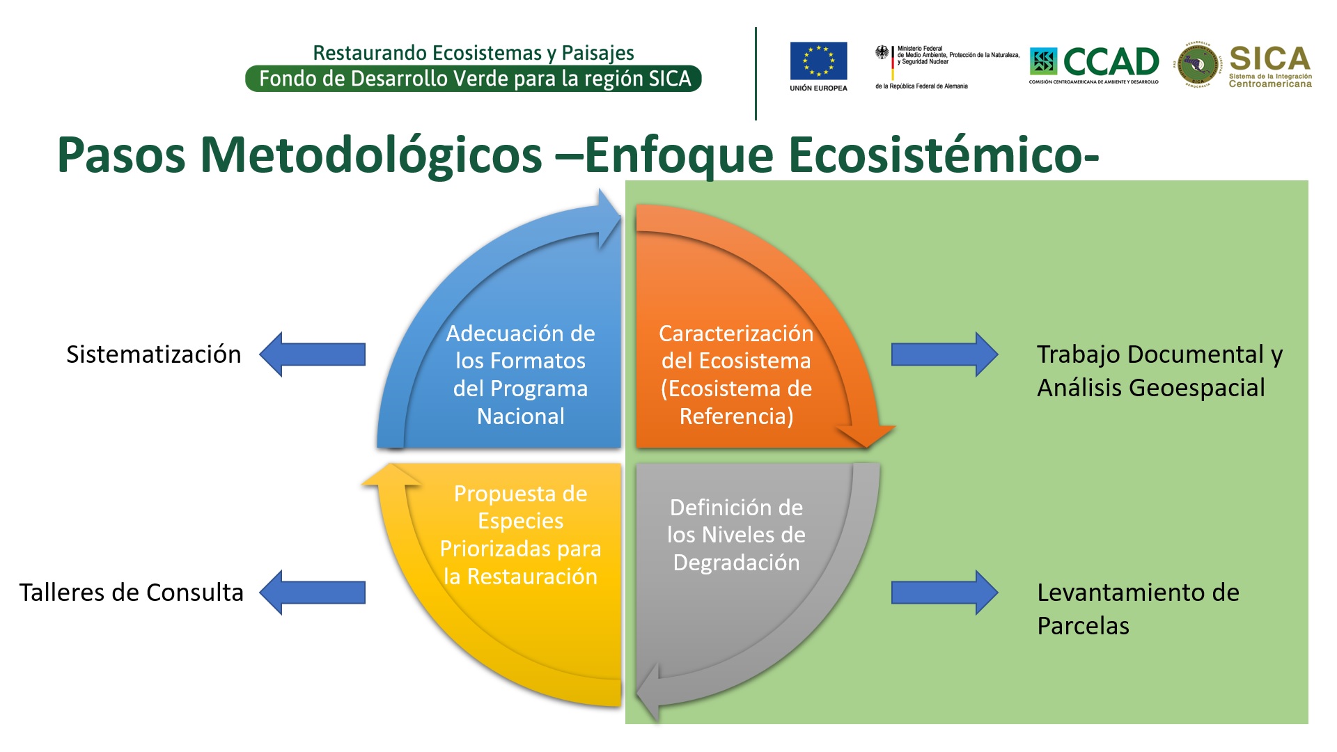
The objective of this building block is to provide technical teams with the biological parameters necessary to determine the current state of an ecosystem (level of degradation) and the desired state (healthy), in order to determine the appropriate restoration measures to be implemented in that specific ecosystem; for example, we will use the case of the Guatemalan dry forest.

The characterization of the ecosystem is done by documentary review and geospatial analysis, identifying the general-initial conditions of the ecosystem and its associations. Distribution / Climate / Soil Quality / Topographic Elevation / Flora Diversity / Fauna Diversity / Dasometric Characteristics of the Reference Ecosystems. For the dry forest, 3 associations were identified: 1) thorny scrub, 2) high dry forest and 3) riparian forest.

The definition of the levels of degradation is done by plot survey, comparing the successional states of the reference ecosystem with the dasometric characteristics obtained from the plots. In the case of the dry forest, three levels of degradation were identified: 1) pioneer succession, 2) secondary forest and 3) degraded forest.

  1. The existence of a policy framework that defines work in strategic forest ecosystems as a priority.
  2. The existence of policy instruments (conservation strategies, general forest management guidelines, etc.) oriented to strategic forest ecosystems.
  3. Groups interested in promoting or updating public policy instruments in strategic forest ecosystems where they implement actions.
  1. The quality of the characterization of the reference ecosystems and their levels of degradation will depend on the quantity and quality of documentary and geospatial information available; the generation of this information and the survey of plots in the field may require a lot of resources and time.
Experimental monitoring system

The experimental monitoring system consists of a set of parameters to track the behaviour of the species, visitor mobility practices, and risk detection:

  • GPS transmitters: they are programmed for data collection and with a download scheduling; there is a zoning around the nest.
  • Axis Station software: Axis Loitering Guard tracks moving objects and triggers alerts (e.g. a user exists the trail for x amount of time), sound alerts, and notifications when a threshold is exceeded. Axis Fend Guard detects interaction events (e.g. the bird leaves the next, two users leave the trail).
  • Alerts for potential mortality, potential territory expulsion, absences at the nest, users near the nest, and noise thresholds.
  • Other data related to trail usage by user type and the Bonelli’s eagle breeding process.
  • Annual reports on raptor spatial mobility, semi-annual reports on interactions and critical events.

It is essential to count on a simple-to-use software programmed with the desired parameters. It is fundamental to make the parameters as relevant as possible to the specific monitoring needs, and as concise as possible so that park managers are able to do a proper follow-up and respond to any alerts.


It should be noted that certain situations involving wildlife cannot be controlled. For example, in our case, we faced the reproduction failure of the pair of Bonelli's eagles, which partly modified the monitoring objective.

Although the use of a more sophisticated alert management software based on artificial intelligence is being explored, a simple software such as Axis Station can do the trick to start developing a functioning monitoring programme that notifies critical risk events. Processes and procedures for pre-alert management and data collection and analysis need to be periodically optimised based on the lessons learned during the process.


Incorporate Coffee Development Measures into Forestry Policies

The purpose of this building block is to develop agroforestry systems management policies in line with coffee growing and link them to the country's forestry development policies, responding to the challenges of the market and applicable international legislation.

In essence, it is necessary to promote incentive policies (economic and/or commercial) that stimulate agroforestry in coffee plantations at the same time, the value chains in the forestry sector as small timber.

This requires two main elements:

  1. The ability to adjust forestry programs to accommodate agroforestry elements, without undermining coffee production but maintaining the spirit of the forestry policy.
  2. Encourage intersectoral dialogue around the issue of agroforestry in coffee plantations, in order to identify points of technical and political coincidence.

To illustrate this building block, the case of the Forestry Incentives Program of Guatemala -PROBOSQUE- is used; which made adjustments to the modality of forestry incentives in the agroforestry modality, changing parameters to include the cultivation of coffee, having a greater impact.

  1. To have a clear forest policy framework, which first, determines the scope of its objective as a public policy, the subject that expects to benefit and the expected results of its implementation; second, the issues where it can and should generate synergies to achieve the objectives of the forest policy.
  2. To have consolidated public policy instruments that allow interaction with other productive sectors. Guatemala's Forestry Incentives Program -PROBOSQUE- originated in 1996 and continues to operate to date.
  1. The development of pilot initiatives is required to evaluate and/or test the technical hypotheses of the different stakeholders in adjusting public policy instruments; in this case the public forestry sector and the organized private coffee sector.
  2. Extensive internal and external discussion and consultation processes are required among the different stakeholders to achieve the benefits of the different sectors, without affecting the institutional and legal mandates that the stakeholders must comply with.
  3. Technical materials need to be developed in order to communicate and disseminate information to potential stakeholders on the new modalities offered by public policy instruments.
Elaboration of a Database on Restoration Measures

The objective of this building block is to provide developers and implementers of ecosystem and landscape restoration projects with a tool for collecting key information in the field to measure the impact of proposed restoration actions.

The steps for its implementation are:

  1. Survey of management units: provides complete information on the sites selected for restoration actions and includes; name and sex of the producer, correlative number and code of the management unit, administrative boundaries, geographic coordinates, area and legal status of the management unit, predominant land use and a photograph of the site.
  2. Survey of the management subunits: provides complete information on the specific restoration measures to be implemented in the selected sites and includes; the codes of the management subunits, coordinates and areas of the management subunits, current land use, future land use, restoration measures and practices to be implemented.

By executing this process, information is available that relates restoration actions to the improvement of ecosystem services in different parts of the landscape.

  • Incorporate new technologies and work distribution schemes to make field data collection and processing cost-effective.
  • Develop communication and performance protocols between office and field teams to collect quality data.
  • Have a supervision scheme that provides timely feedback to data collection and processing, while avoiding reprocessing.
  • The process of collecting management units is the most time-consuming part of this solution (estimated to be 2% of the project's execution cost), and therefore requires detailed and precise planning of the technologies to be used, the number of personnel required and the ways in which the data will be processed, as failure to do so in an appropriate manner may increase costs.
  • To take care of the processing and quality of the data, cross supervisions (internal personnel of the organization that is not linked to the project) or outsourced (external personnel that have been hired for this purpose) are required, which can identify inconsistencies in the databases and what has been executed in the field.
Use of data for decision-making and planning.

SAGE Findings:

  1. Little involvement of fisherwomen in LMMA decision-making, discriminated against because of mosquito net fishing.
  2. Lack of recognition of community rights to participate in LMMA decision-making.
  3. Major deficiencies in the process of complaints and follow-up of cases related to invasion of the reserves by the entire community due to the lack of inspection instruments.
  4. Deficit of collaboration and coordination, it does not share reports and plan of activities between different actors.

Recommendations:

  1. Involve mosquito net fisherwomen at all stages of LMMA establishment and prioritize opportunity costs for them.
  2. Disseminate information on rights to participate in LMMA decision-making to all community.
  3. Encourage community to report offenders and follow up on cases related to the invasion of the reserves. 
  4. Promote regular meetings to share reports and activity plans between actors.

Based on these recommendations, the project is implementing bivalve aquaculture, prioritising women’s involvement to address opportunity costs. We are supporting annual district, provincial and national stakeholder meetings. We are supporting CCPs with equipment for improved LMMA enforcement. We are strengthening CCP skills for communication and equitable governance through training by AMA.

The purpose of this exercise needs to be well understood by the focus group members. It must exist a will to improve existing conditions by the focus groups members and they must recognise change is possible.

SAGE and IMET methodologies are the simplest, fastest, easiest and cheapest way to evaluate and monitor the progress of a project. Before adopting these tools, the project used only EXCEL to analyse the data, and this was time consuming and expensive as we needed to hire consultants to conduct the surveys. Data analysis and interpretation was also done manually, which too was time consuming.

Participatory Assessment

Data Collection, Data Analysis and Data Synthesis:

Organised groups of actors from different social backgrounds gathered for this process, which was facilitated using the local language and a translator was engaged to assist with the translation. To take into account the level of education of participants, we defined the appropriate means of communication. People participated according to the same interest group or social status (Community Fishery Council, fishermen, fisherwomen, government, influential members and income generation alternatives, among them). In the first phase, discussions were done separately and later discussed in plenary; after the discussion participants reached consensus, it is this consensus that was considered as the final response. To ensure that the selection of members taking part in each target group was inclusive, it did not take into consideration party affiliation, religion, social level, gender. During the meetings we also explained the importance of the SAGE process.

FPIC standards (Former Prior Informed Consent) must be applied to maximise genuine participation. The data collection/facilitator team should be well known by the community members and recognised as trustful. There should be a sense of long-term engagement in support of the community.

One of the lessons learned was to present the results of the issues discussed separately in a plenary, where members of different groups discuss the same ideas and reach consensus.

A sign that we are valuing local knowledge.

And that is good for the success of a community-managed conservation area.

Stakeholder identification and analysis/site profile analysis.

Analysis and identification of actors/stakeholder:

In order to understand the stakeholders in the project area, all actors in the district who are capable of supporting the establishment of LMMAs were ranked by capacity to contribute to its implementation. The ranking was from 1 to 3 points (1 – low, 2 – medium and 3 – high). Only the stakeholders that had a score of 3 points were selected, namely, government, Community Fisheries Council, fishermen, fisherwomen, influential members (community and religious leaders) and alternative income generating activities groups.

Stakeholders were then engaged through the SAGE/IMET methodologies, through the introduction and background workshops and through partaking in the assessments themselves.


Profile of the study sites:

Characterization of the study site which includes the type of habitat we are protecting, the species, the type of reserve we are implementing which are temporary and permanent reserve (temporary for short-lived species, in this case octopus and for the purpose of increasing household income, and permanent reserve or restocking for biodiversity conservation for generations to come, but the same may cause overflow of fish into the area where fishing is allowed) dimensions of the reserves, legal framework.

Key enabling factors in this building block include involving project team members who have a strong and in-depth understanding of the communities and landscapes within which we work to ensure that all stakeholders are identified and then ranked correctly. Additionally, it is important to have a wide representation of team members to have an increased range of opinions on stakeholders’ capacity to implement LMMAs and how best to engage them.

In order to ensure smooth data collection among the focus groups and stakeholders it is important to (i) have clear questions and make sure the issues were well perceived by everyone, (ii) take into account the time required for translations when necessary, and (iii) enable the expression the divergence of opinion. Furthermore, the multi-stakeholders consultation (featuring the presentation of IMET and SAGE assessments’ results) needed to be repeated several times to get buy-in from all stakeholders for elaborating the enhancement plans to improve the LMMA co-management plans. 

Training participants in the SAGE and IMET tools.

The first part of this project was training participants on SAGE. To make the SAGE more applicable to our situation, we chose six of the most important principles that are relevant to the LMMA:

1: Respect for resource rights and human rights of community members

3: Effective participation of all relevant actors in decision making

4: Transparency, information sharing and accountability for actions and inactions

8: Equitable sharing of benefits among relevant actors

9: Achievement of conservation and other objectives

10: Effective coordination and collaboration between actors, sectors and levels


The SAGE methodology is a participatory process, conducted with: Community Fisheries Council, fishermen, livelihoods group, community and religious leaders, district and provincial government.


The IMET was supported by two consultants from the National Administration of Conservation Areas. Various actors were invited: a) National Fisheries Administration, Provincial Service of Economic Activities, Provincial Directorate of Environment, Provincial Directorate of Tourism; b) District Service of Economic Activities, Maritime and Lake Police, Administrator of Quirimbas National Park and Justice Authority; c) Community Fisheries Councils, fishermen, community and religious Leaders).

The two tools, IMET and SAGE, value local knowledge, so the contribution for all actors involved in the process was very positive. It was also a positive process because through this tool, the community understood that management power can be transferred to the community from the government, increasing their sense of ownership and empowerment. Prior to this, the majority of the community thought that the management of the reserves was only for the Conselho Comunitario de Pescass and not for the whole community.

The good communication and the results of the opening of the temporary reserves (octopus) helped the communities to understand that the reserves belong to the community and are for the benefit of the community, hence neighbouring communities have started to request the project to create new conservation areas.
Funded Projects

Following two funding calls, a total of 17 projects were selected. The projects represent a very wide range of different approaches and solution ideas for pursuing the Alliance's goals, depending on the respective context.

To increase the visibility of the projects and to foster knowledge exchange they are invited to present their ongoing work, intermediate goals and preliminary results to the Alliance community through posts on the website or at online events.

Sufficient funding is necessary to ensure long-term support and sustainable implementation of the project goals.

Continuous communication between those responsible for the project and the Alliance secretariat ensures the success of the project, the feedback of results to the community and thus added value for the community.

Adequate feedback from project partners can be challenging and requires good communication strategies.

Country packages

The aim is to establish practices, rules and/or standards to reduce risks to the environment, human and animal health in trade in wild animals and wild animal products in selected partner countries in global biodiversity hotspot regions. Among other things, risk assessments, the design of educational measures in different formats (digital and non-digital campaigns, training courses, etc.) and the scientific monitoring of the implementation of good practices (e.g. impact assessments) are to be promoted. The Alliance brings the relevant actors together across sectors and use concrete findings to formulate adapted regulations or or supports the institutionalization of relevant practices.

Existing political and GIZ structures, as well as other local partner organizations in the selected partner country.

Depending on the initial situation in the partner countries, you have to start at different levels. In some cases working together at the political level is possible, in other places it is more effective to implement the goals via a partner organization that already has experience on site and a network of local actors.