Financial support by national government and schemes to reduce financial burden of local governments

The national government provides local governments with additional subsidies for seismic retrofitting and reconstruction of schools with insufficient seismic capacity. In principle, national subsidies for retrofitting and reconstruction cover one-third of associated costs for public elementary and junior high schools, but the national share has been raised to two-thirds and one-half respectively in 2008 under the Act on Special Measures for Earthquake Disaster Countermeasures. Furthermore, additional sources of funding were generated through local bonds and local tax allocation by local governments. In Shizuoka prefecture, located in the Tokai area where earthquake probability is high, the local government increased corporate income tax by 7-10 percent for 15 years to allocate budget for making public buildings more earthquake resistant. Kushiro municipality’s retrofitting completion rate remained at 50 percent for a decade due to lack of funds, however, this increased the rate to 85.8 percent within 3 years of introducing the PFI system.

  • Mutual understanding of stakeholders of the importance of investing in the retrofitting of schools.
  • Commitment by municipal governments on the promotion of the program.

Proactive support by the national government was an essential part in achieving the retrofitting of schools across Japan. Progress to achieve the goal of the program was initially slow due to the financial burden on the local governments. The national government responded by increasing the national subsidies in seismic retrofitting and reconstruction. In addition, when there was difficulty in securing sufficient funding for retrofitting subsidies from the initial national budget, the government explored the use of supplementary budget and reserve fund.

Monitoreo una herramienta fundamental para evaluar la efectividad del manejo del PN Zona Marina Archipiélago Espíritu Santo

El punto de partida para las acciones de monitoreo y evaluación de cualquier Área Protegida (AP) es contar con una línea de base, es decir, un documento que describe con detalle la situación del área antes de que se implementen las primeras medidas de manejo. A partir de una línea base sólida estructurada con los indicadores pertinentes, y el monitoreo de dichos indicadores, es posible efectuar un manejo adaptativo del AP y ser susceptibles a cualquier cambio en el entorno socioeconómico, biofísico y de gobernanza.

La línea base del Parque Nacional Zona Marina Archipiélago Espíritu Santo inicio 5 años antes de ser decretado como Parque Nacional, y es con esta línea base que se ha construido un programa de monitoreo submarino para el seguimiento de indicadores socioeconómicos  gobernanza y biofisicos.Usuarios de los recursos pesqueros, Patrones de uso de los recursos pesqueros, Conocimiento acerca de la historia natural de los recursos pesqueros, Número y Naturaleza de los mercados, Caracterización y nivel de amenazas de los recursos, Conocimiento acerca de las regulaciones pesqueras y ambientales, Análisis de abundancia, riqueza, diversidad y equidad de los peces e invertebrados en el área marina de Espíritu Santo, Distribución y complejidad de los hábitats.

Una línea base sólida de información biofisica, socioeconómica y de gobernanza es fundamental para el monitoreo de los indicadores de evaluación de la efectividad del manejo del área protegida.

Aspectos relevantes y lecciones aprendidas:

1. La construcción de las lineas base requieren una importante participación de la academia, centros de investigación, organizaciones de la sociedad civil, pescadores, habitantes de las comunidades y usuarios

2. Utilizar también en la construcción de las lineas base, toda la información disponible que sea verificable

3. Es fundamental la contrucción de lineas base con series de tiempo que cubran las historias de vida de los aspectos biológicos, a fin de que queden cubiertos las etapas de reproducción, alimentación de las especies relevantes

4. Las lineas base de aspectos socioeconómicos y de gobernanza deben actualizarse continuamente, considerando para ello los procesos sociales locales y económicos regionales que pudieran impactar 

Evaluación de la efectividad del manejo del Parque Nacional Zona Marina Archipiélago Espíritu Santo

 La evaluación de la efectividad se realizó mediante: (1) Diseño de un protocolo de monitoreo (2) Capacitación de los monitores (3) Selección de los sitios de monitoreo, similares entre si y representativos de las Zonas Nucleo y Zonas de Amortiguamiento; (4) Se establecío la linea base; (5) Analisis de los datos (6) Como una medida de manejo adaptativo se establecieronestrategias, como la inclusión de otros sitios, los arrecifes artificiales (7) Se comparó la información entre los sitios de muestreo (8) Se hicieron las recomendaciones, y dentro de los principales resultados que se obtuvieron a lo largo del periodo de monitoreo se mencionan los siguientes: 


1. Al prohibir la pesca en algunas áreas, el número y el tamaño de peces aumenta, resultando en una mayor depredación de invertebrados.

2. Se ha mantenido alta la biodiversidad de la zona

3. En las Zonas Nucleo son las áreas de reproducción y alimentación en donde se mantienen sus poblaciones

4. Una recomendación importante es mejorar la vigilancia local y difundir los resultados del monitoreo en el cual participan los pescadores y usuarios del parque, con la sociedad de la ciudad de La Paz, a fin de que se conozcan los resultados exitosos de un trabajo conjunto realizado por la academia, los pescadores, usuarios y personal del área.

La evaluación de la efectividad del manejo  del Parque Nacional utilizando indicadores biofisicos, es fundamental para establecer que tanto éxito se tiene en alcanzar resultados de conservación de los ecosistemas y su biodiversidad, es con esto como es pósible demostrar que se están alcanzado los objetivos para los que fue creado este Parque Nacional "albergando gran variedad de peces, aves y mamiferos marinos, habitat de fondos arenosos, arrecifes rocosos" conservados con integridad ecológica.

Las lecciones aprendidas son:

1. La mayoría de los peces e invertebrados marinos hacen uso de más de un tipo de hábitat a lo largo de su vida. Esto es relevante porque no siempre es posible proteger un área entera o una población con distribución amplia, y sí un área particular en donde los organismos pasan parte de su ciclo de vida.

2. Las tres zonas núcleo, San Gabriel, Los Islotes y Punta Lobos a La Bonanza, fueron identificadas como zonas de importancia para la pesca. Sin embargo, cada una tiene un objetivo distinto, por lo que es necesario preguntarse si están cumpliendo los objetivos para los que fueron creadas.

3. El monitoreo de indicadores biofisicos debe ser a largo plazo, a fin de contar con una serie de tiempo de los procesos biológicos, ecosistemicos y físicos 

4. La construcción de los indicadores biofisicos para establecer la efectividad de las acciones de manejo para la conservación de los valores naturales del área protegida, deben tener en cuenta la importancia de lineas base  
Ensuring Economic Inclusion through Connecting Lagging Neighborhoods to Jobs

There have been few companies offering jobs in the Airin district other than constructors since the 1980s. Under the Nishinari Special District Vision, the reconstruction of the Airin District Comprehensive Center gave the opportunity to encourage companies to offer jobs other than casual construction jobs. The Nishinari Labor Welfare Center within the Airin District Comprehensive Center supervises job recruiters. The Nishinari Labor Welfare Center aims to give guidance to such informal recruiters and formalize them. This has increased the job spectrum for the residents and day laborers and has further enhanced the local economy and status of the neighborhood. 

- Renewal of an old district center to serve as a job placement office

- Cooperation with labor welfare office to create more formal opportunities for unstable job labors

Airin district had been a hub for day laborers in the past, which has merely been reduced to construction jobs lately, in both formal and informal sector. It was realized that for the development and progress of district and ward, economic inclusion through job creation is key. 

Enhancing Spatial Inclusion through Strategic Choices for Management of Public Spaces, the Location of Urban Amenities, and Social Infrastructure

In 2012, the City of Osaka launched an extensive project called the Nishinari Special District Vision, which aimed to revitalize Airin district. This project, combined with the bottom-up measures, allowed community improvement measures to be implemented at an unprecedented rate. A sum of 6.7 billion yen was invested over a span of five years.


The Nishinari Special District Vision intended to take measures for revitalizing the area, protecting the living of the people who have been living there. For immediate change of perception, it came up with a slogan “a town where children's voices can be heard”.


The vision plan was organized into three phases:

Intensive phase: the decision was made to carry out measures aimed at improving the community environment, such as tuberculosis prevention and setting up security cameras.

Mid- to long-term measures:  it involved the provision of quality housing for households with children, putting in place a hub for international tourism, among other measures.

Future Investment Project and Major Undertakings phase: to define the redevelopment of the station front area and the effective utilization of unused public land.

- Strategic choices in the district vision by the municipal government for management of public spaces, the location of urban amenities, and social infrastructure

- A clear future vision shared with a wide range of stakeholders

Impact of Nishinari Special District Vision and bottom-up measures led to a significant change in Airin district’s public perception. In the past, there had been a strong perception that Airin was a dangerous, dirty, and untouchable town. In recent years, however, there has been a rise in the number of tourists (from overseas as well other parts of Japan) who want to see the real Osaka in a friendly atmosphere of a traditional commercial and working-class neighborhood.

Enhancing Social Inclusion and Cohesion through Investments in Urban Services

Measures for public welfare were divided into two approaches. One was the improvement of welfare for residents, using community-based welfare facilities. The facilities provided services such as employment support, education, and medical care. The other was municipal houses, such as Osaka Municipal housing and Osaka Prefectural housing for low-income families living with poor living conditions. Airin General Center, which had three functions of medical care, housing and labor, was established in 1970.


Apart from these public efforts, the Supportive House system, carried out by a private social company without the government’s financial support, was established in the 2000s to provide support to poor people for housing. Though the influence of the system on the whole district is limited, it has still managed to provide 700 rooms.  

- Public and private investment to improve existing urban stocks including old community centers and public housing

In Nishinari ward, application of existing clearance-type improvements was very difficult since the area was large and basic infrastructure being relatively poor, so the approach adopted was to utilize the existing stock of the old built-up area efficiently. The redevelopment of Airin District, on the other hand, could cause gentrification and destroy the multilayered safety nets established in this area. For a positive spatial impact, conscious efforts have been made to avoid gentrification, which has kept the issues, such as forcible expulsion of welfare beneficiaries and homeless people, at bay. Revitalization of the region that will not exclude socially vulnerable people is more important than anything else.


Engaging Citizens & Building Trust in Local Authorities via Participatory Approaches and Tools

For revival, Airin district needed bottom-up approach, which aims to put emphasis on local residents’ actions and listen to them and relevant organizations, departing from a traditional method of governmental organizations-led decision making. The district started an urban regeneration forum led by a public entity in late 1990s to facilitate discussion and dialogue among different stakeholders, which is followed by various community institutions funded to foster communication by involving all interested groups.


Nishinari ward office plays not only coordination mechanism but works as a part of the team aiming to develop Airin District. Airin was indeed a lagging district, and the level of mistrust was extremely deep. The local authority was therefore conscious of offering inclusive service and working with politeness and high respect to residents. It gradually melted the tension. While Mayor Hashimoto largely triggered the reform, the residents kept its implementation through a public-private forum called area management secretariat. 

- Step-by-step efforts made by the local government to steadily involve fragmented stakeholders.

With the area management secretariat, the district invited a wide range of stakeholders to city planning, for the first time in history. From Airin district story, a clear lesson to learn is how critical inclusiveness is when making a change or reform, even if the change gets slowed down with too many stakeholders. The secretariat triggered public space improvement, solving crimes and violence issues, including drugs, and creating job opportunities for the residents. It was a case of building and practicing a true democratic process, which may be slow but efficient and important for bigger changes.

Promotion of income-generating activities and of improved stoves

The lack of fire and construction wood is a major challenge for the beneficiaries of the initiative. Therefore, we put into practice a holistic and inclusive approach:

  • Strengthening the beneficiaries’ capacities for setting up and managing a social community space, taking into account the necessary resources
  • The collection and processing of NTFPs from the restored plot, such as Neem seeds for oil production (income-generating activities)
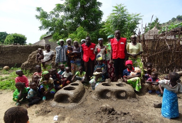
  • Gender mainstreaming: construction of improved stoves that is carried out by two Trainers Coordinators: Woman/Man who supervises the activities, who will in turn train Relay Trainers in the target villages  in construction, awareness and means of popularization of improved stoves and aware of the problem of wood energy. TwoTypes of improved stoves were used: "foyers améliorés 3 pierres", "foyers améliorés Bill-Bill". They increased their source of income, reduced the use of firewoods.
  • While the recently planted trees and plants are still growing, 35 women have received training to build improved stoves using clay and straw which are raw materials found in nature (zero cost). This improves the living conditions of the population and reduces the pressure on the remaining natural resources. 
  • Effective participation of women
  • Availability of the raw material (clay and straw)

Two women form a neighbouring village (Doualaré), who themselves were trained by GIZ Wood-Energy Experts, trained the women of the project site regarding the construction and use of improved stoves. This kind of ‘farmer-to-farmer training’ empowers women and disseminates the techniques.

Development of specific techniques to protect and irrigate the plants

The community tested various techniques to fend off stray livestock following the planting period. These included protecting the area with a dead hedge made of thorny branches, with pink morning glory (Ipomea carnea) woven rods supported by poles and with iron wire from the carbonization of worn car wheels. These efforts were, however, without much success. In addition, following the long dry season and the low rainfall in the region in 2017, the community’s water source dried up and the plants withered. The idea of collecting water with empty cans at the community’s water borehole (~ 3 km) was not feasible due to the lack of financial resources.

However, another system through drip irrigation devices made of used bottles collected in the city was also used. Drip irrigation devices were attached to the foot of seedling. The water was then drawn from barrels and stored on site. This system permitted the seedlings to be watered three times a week allowing nearly 40% of the wilted plants to grow again. The construction of a permanent plant nursery with an onsite water borehole has been as well finalised.

  • Capacity building of the local facilitators in the ‘learning by doing’ method to develop restoration techniques allowed the production of 2600 plants in 2017
  • Ability to develop one-off actions that can be improved depending on the situation. 

  • Individual plant protection approach. e.g. use of a mat to protect the plants (see pictures)

  • Use of a drip irrigation system with reused water bottles
  • Promotion of the separate production of livestock fodder
  • Difficulty to access water, which is primordial for the growth of fruit trees that require irrigation during the long dry season. Of the 4022 seedlings planted, 2162 are alive and 1860 dead on eleven blocks containing eight fruit and forest species in August 2017
  • The benefits of constructing a village plant nursery with an onsite water borehole (permanent production of quality plants, livestock watering, human consumption and therefore reduction of waterborne diseases, which causes the high infant mortality rate in the community)
  • The possibility of dividing the plot into sub-plots of approximately 500 m2, which will be gradually restored (year 1, year n+1, year n+2, ..., year n+5), in order to make it more secure
Micro-zoning of the selected plot according to the soil type, the topography and the identification of adapted local plant and tree species

Community members and experts developed a topographic map of the selected plot showing the different soil types and adapted local plant and tree species. Two main soil types have been identified:

  • The soils of the mountainsides: stony surfaces; horizon 1 (0 to 20 cm) is silty sandy with a mixture of stony grains; horizon 2 (20 to 40 cm) is dominated by large stones and a small proportion of soil and horizon 3: (40 to more) was not accessible. For this soil type, the appropriate species are: Acacia (Acacia nilotica, Acacia Sieberiana, Acacia seyal), Neem Azadirachta indica, Anogeissus leiocarpus, Jujube (Ziziphus mauritiana), River Red Gum (Eucalyptus camaldulensis).
  • The site bed is dominated by vertisols (i.e. soils with a high content of expansive clay minerals) with local withdrawal slots: horizon 1 (0 to 40 cm) composed of silt and clay and horizon 2 (40 to more) a mixture of silt, clay and stony grains. Suitable species include: Khaya (Khaya senegalensis), Cassia (Cassia siamea), African black plum (Vitex doniana), River Red Gum (Eucalyptus camadulensis), Winter thorn (Faidherbia albida), Cashew (Anacardium occidentale) and other fruit trees.


Depending on these different soil types, a mini-zoning allowed to delimit 11 blocks occupied by eight selected species.

  • Full involvement of the designated local facilitators who are willing to follow-up on the activities on a daily basis
  • Participatory selection of the plant and tree species to guarantee a useful reforestation
  • Adoption of the micro-zoning approach

It is pivotal to take into account the physical characteristics of the plot for the success of the initiative including soil characteristics and topography by involving local experts. This allows to identify solutions for restoration that are sustainable and profitable in the short, medium and long term.