Shared governance process
With the transformation of traditional management systems as well as stakeholders intervention scales, new rules are being defined in relation to the access and use of natural resources. All stakeholders are involved in a shared governance process. The iterative process was implemented successively at the village level, then at all stakeholder level, at every stage: information, consultation, negotiation, implementation. The whole process took place over a period of four years, but experience shows that facilitation is still needed in the long term. IUCN played a facilitator role in the process, and tried to stay neutral while providing technical and methodological guidance.
A good knowledge of shared governance techniques; An understanding of the socio-economic, cultural and environmental contexts, and the potential sources of conflict; Flexibility and time to reconcile the views and interests of the various stakeholders; Tangible support actions to the stakeholders that meet their real, practical needs; Communication and education actions; Training.
As a starting point, it is crucial to consider the tangible and immediate concerns of the relevant population groups. Only afterward that can they gradually be engaged in dialogue, consultation and negotiation. It is necessary to have accurate and updated information on the situation of the environment, resources and socio-economic aspects of the relevant stakeholders. A recognized and objective coordination structure is necessary for a balanced consultation of stakeholders. Take the time necessary to reconcile the views of the various stakeholders. Do not rush the process in order to be able to meet the commitments made to the donors.
Public-private collaboration for conservation
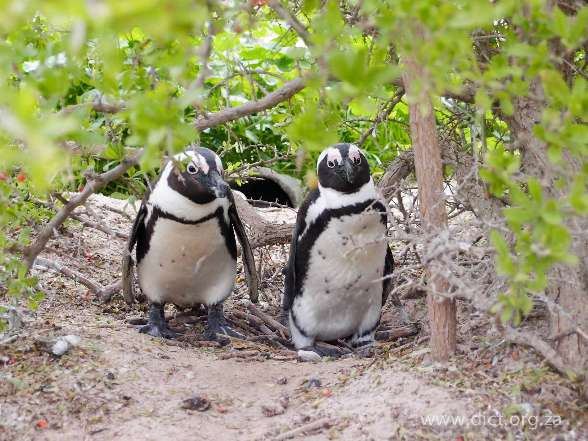
businesses. Together with the tourism partner companies, DICT conducts research, conservation and education in the marine environment of the Gansbaai district in the Western Cape. The commercial companies provide logistical and onsite support for biologists and the Trust to operate, while political support is provided by the Municipality and Cape Nature DICT projects are focused on the Marine Big 5 – African penguin, great white shark, Southern right whale, Cape fur seal, dolphins - surrounding Dyer Island. Dyer Island is a breeding colony for the endangered African penguin and an Important Bird Area. The successful collaboration in this public-private partnership has grown organically and is unique to the context and stakeholder landscape in this particular destination. However, there is clear scope for replicating this model, by identifying the key touristic value provided by a given ecosystem based attraction, creating broad awareness around it amongst all relevant parties in a destination and then build a commercially and environmentally successful strategy and multi-stakeholder governance body around it.
o Success of commercial businesses by constantly reinvesting profits into the companies: Monitoring research to enable conservation of coastal and marine ecosystems, which are the main asset of the business model on the Cape Whale Coast. Similarly, investing in bigger boats and other physical capital would be redundant if the natural capital assets were to erode further. o Partnerships with other businesses in the destination, tour operators, other non-tourism businesses; local government, non-profits such as Fair Trade Tourism and the general public
While the Trust has been instrumental in raising the profile of this incredible marine area, none of the conservation, research and education work would have been possible without successful commercial businesses. For example, the daily data capturing and observations of marine animals and seabirds have been instrumental in conclusions with regards to their behavior – and have led to important scientific publications. Funds toward the Trust are also raised by the companies, ensuring its financial stability. The Trust aims to protect the marine heritage and was able to submit a letter of concern regarding the proposed nuclear power plant at Bantamsklip, just over 22 km from their office in 2010. Based on the wealth of its own research findings and local knowledge it was possible to point out critical flaws in the Environmental Impact Assessment. As a result, the University of Pretoria will in future be consulted regarding the species of this area and any possible monitoring programs.
Conservation of key flagship species
DICT installs shelters that mimic the natural burrows of the penguin, essentially creating homes for the breeding pairs and improving the chances of fledgling survival success. They have created a fibreglass/mesh resin nest that is lightweight yet durable and is made by the local community. DICT continuously records streams of seabirds, especially penguins that are found injured, oiled or sick on Dyer Island and the adjacent coastline. All vagrant and visiting seabirds are logged and GPS positions supplied for scientific research. DICT has built the first rehabilitation centre in the area: The African Penguin & Seabird Sanctuary, to assist in the conservation of all seabirds. Together with Marine Dynamics, DICT has funded a custom designed research vessel and developed a project where they acoustically track great white sharks in the area to better understand their behavior in relation to environmental parameters. Also a database of fin ID photographs from 2007 to 2012 taken off Marine Dynamics shark cage diving vessel helped in the first regional population study (showing lower numbers than previously assumed). The ultimate goal is protection of the Great White shark species and a growth in numbers for the African penguin.
o Leadership, vision and determination by the founder and owner of Dyer Island Cruises, Wilfred Chivell, to conserve the local marine biodiversity through tourism o Success of commercial businesses: revenue generated by tourism provide the financial means to reinvest in the protection of the Marine Big 5 – the key asset and natural capital along the Cape Whale Coast o Regular collection and monitoring data by DICT and its partners, without which no measurable conservation efforts could be done
To date over 2000 nests have been placed on Dyer Island and other breeding colonies and due to its success forms part of the Biodiversity management Plan for the African Penguin. DICT has also established itself as a capable institutional setup to successfully help stranded whales/dolphins/seals and assists wherever they can. As a result of adequate tracking data of the Great White Shark over a reasonable time period and better understanding of the sharks’ usage of Gansbaai's shallows as well as a crucial population study, the DICT can more effectively protect the white shark and its key foraging areas whilst informing and protecting beach users. Interactions between other marine life and great white sharks can be determined and communicated to scientists in various fields which present the unique opportunity to network and asses the white sharks role within the entire ecosystem. Knowing how few sharks there are means the DICT can effectively change government conservation policy.
Fishing Line Recovery Program and Blue Flag
DICT in association with the Overstrand Municipality established the Fishing Line Recovery Program along the Gansbaai shoreline. By increasing public awareness about the negative impacts that fishing line debris has on marine life, water quality, and human welfare, we reduce the amount of fishing line entering and remaining in the sea, and increase recycling of fishing line. A network of fishing line recycling bins has been placed at local beaches and popular fishing spots. This project has become an icon for marine litter and the Trust is part of a Technical and Advisory Committee addressing marine pollution. The vision is to see this project grow along the South African Coastline. In October 2011, part of this vision was realized when together with WESSA (Wildlife and environment Society of South Africa) and the Blue Flag Beach Program, the bins were being placed adjacent to all Blue Flag beaches. Blue Flag is one of the most well-known international voluntary eco-labels for beaches, marinas and boats. In 2013, for the first time, marine protected areas (MPAs) were included in the International Blue Flag Criteria. Whale Whisperer, a whale watching boat has Blue Flag status and was the pilot Blue Flag boat in South Africa.
o Successful commercial business o Support of clients, local government and the Blue Flag program
The Trust has greatly benefited from its approach to involving, then working closely with the Overstrand Municipality and gaining their support. This was one of the foundations to receiving further financial support through a donation from the Southern African Plastic Pipe Manufacturers Association and DPI Plastics, arranged by John Kieser of Plastics SA. The material was enough to make 100 bins – 54 dedicated to the Blue Flag program. The low cost of only R350 per bin, provides an easy way for any individual willing to support this project, which has added a crucial element in enabling its growth and the development of marine pollution educational materials. Local authorities around the world report a number of spin-offs from being awarded Blue Flag status, including an increase in visitors, improved behaviour on the part of beach-goers, property prices rising for homes near Blue Flag beaches – and visitors enjoying a well cared-for and managed beach.
Strengthening transboundary cooperation through joint action
For transboundary cooperation to work, it is important that the transboundary National Parks work together on common tasks and activities. This can be achieved through joint implementation of projects. In the case of Oulanka National Park in Finland and Paanajärvi National Park in Russia, many projects have been implemented in order to solidify these two entities into one real functional unit – a twin park – that serves as a model for transboundary cooperation. The Interreg/Tacis Joint Project “Oulanka-Paanajärvi – wilderness, experiences and well-being” contributed toward ensuring ecological and socio-economic sustainability of Oulanka and Paanajärvi National Parks while preserving and enhancing attractiveness of the region for visitors and to make the twin park the most important and attractive destination for nature-oriented tourism in the region. This in turn creates possibilities for entrepreneurship and preserves and strengthens employment opportunities for local people and entrepreneurs. Joint management and implementation of the project was an important tool in making transboundary cooperation part of the daily work in the management of the transboundary National Parks on both sides of the border.
It is helpful if transboundary cooperation has recognition on a higher level than just the National Parks. In Oulanka-Paanajärvi twin park, in addition to the joint agreement of collaboration there is a convention between the Finnish and Russian governments as well as a memorandum between the regional governments. The commitment of twin park managers and personnel to reaching common goals and working together is essential. Promotion on both sides is important and helps nature tourism businesses in creating sustainable transboundary products.
The best way to make transboundary work part of daily activities of managers and personnel of the National Parks is to do actual work together and in such a way that all levels of personnel participate in the work. Transboundary work cannot be just meetings between higher level staff but actual hands-on work by all levels of personnel. It is important that the staff members that have knowledge of the language spoken in the NP across the border or another common language actively act as interpreters in order to help communication between personnel in transboundary NPs. Language learning should be encouraged and supported by the management of NPs. It is also important to celebrate the achievements together and invite local people, businesses, local and regional government and media to take part in the events. It is important to make new history together especially in Oulanka-Paanajärvi region where wars were fought and the border was closed for a long time.
Enhancing sustainable tourism in transboundary NPs
Nature is the basis for nature-oriented tourism and recreational use of nature, thus nature tourism must be sustainable: not threatening natural values and respecting local culture. Sustainability of activities is a precondition for use of NPs, continuity of nature-based tourism and recreational use of nature, and regional attractiveness. Assessments of ecological sustainability of tourism and recreational use of nature were conducted in Oulanka and Paanajärvi NPs by research institutions. The method ‘Limits of Acceptable Change’ was used to determine limits of ecological sustainability as part of a Sustainable Tourism Development Strategy in Oulanka NP. Waste management practices and public awareness of waste management were developed in Paanajärvi NP. A Sustainable Tourism Development Strategy (STDS) was developed in Paanajärvi NP to match the already existing one in Oulanka NP. The STDS is an instrument for attaining long-term sustainability of ecological and socio-economic development of the territory. Work on STDS enables an objective assessment of the present situation of the transboundary NPs and adjoining areas in relation to development of tourism and to develop a plan of future activities for the whole territory.
It was important that there was sufficient data collected on natural and socio-economic conditions of the National Parks in order to make an educated assessment of the sustainability of nature-based tourism and recreational use of nature. Good cooperation with stakeholders that have an impact on National Parks was vital as was mutual commitment to the importance of strategic planning of the Parks and their surrounding area. Monitoring of the factors used to determine the limits of acceptable change is essential for long-term sustainability.
It is important to reserve sufficient time to build the base for cooperation and understanding of the methodology and process of developing a Sustainable Tourism Development Strategy for a National Park. It is also important to engage the stakeholders early on so that they feel that their views and opinions are taken into account. This enhances the commitment to implement the STDS by all involved. Collection of baseline data and information and monitoring of relevant factors is essential if real sustainability in the use of National Parks is to be reached. Also the limits of acceptable change should be open for revision as new data are collected. Sharing of work methodologies and information across the border in transboundary NPs improves coordinated actions that benefit NPs on both sides of the border, thus also making the management of transboundary NPs more in line. This transboundary cooperation is essential to ensure ecological sustainability, as nature knows no borders.
Training and certification of National Park guides
A competent guide and site-specific information deepen the visitor experience and understanding of natural and cultural sites. There is a need for increased quality in the range of nature-based tourism products and guides specialised in sites and site-specific information to intensify the visitor’s experience. The project answered to this challenge by developing a training system for nature guides as well as the principles governing the certification of guides for Oulanka National Park in Finland. Four guides from the Russian Paanajärvi National Park participated in the training course for nature guides in order to learn about the training and its applicability in Paanajärvi NP and to enhance their knowledge of Oulanka NP as well as to form personal links with Oulanka NP staff. Other participants of the training were guides of local nature-based tourism businesses. In order to be certified, the guides had to pass the tasks specified in the training programme. The training was given by NP specialists and practical arrangements were organised by a co-operating educational institute.
The interest of the local nature-based tourism businesses to have their guides participate in the training course was the most fundamental factor. This meant that the businesses were willing to invest in their guides, as they believed it would ultimately be beneficial for the business. The National Park’s willingness to provide resources (staff and funding) for the training was of vital importance. Open and constructive dialogue between NP management and businesses was very important during the training.
The training was a great way to get to know the local nature-based tourism businesses and the people that work in them. We (managers of National Parks) learned about the realities of business, while the business entrepreneurs learned about our management philosophy and got to know us personally. After the training, the entrepreneurs saw us as actual people rather than just authorities enforcing laws. This helped improve relationships between NP managers and the entrepreneurs. During the training, it is important to have time for discussions and sharing as these strengthen the bonds between people. It is very important to do the training on the guides’ terms: they are used to oral presentation, not written, so it is good to formulate the tasks so that not much paper work is needed on the trainees’ part. It is good to make the certified guides public and give them the right to use a certified guide badge. It is vital to take into account the tourist season and avoid training during it.
Development of GIS-based electronic information points
The aim of the electronic information points is channeling visitor use in order to help avoid congestion within Paanajärvi and Oulanka NPs and thus to enhance possibilities of nature experiences for visitors and to safeguard biological diversity and ecological sustainability of the NPs. Through the information points visitors can obtain easily accessible, fun and entertaining information of the possibilities for experiencing nature in Oulanka and Paanajärvi National Parks and in other areas in their vicinity, encouraging also visitation across the border. The information points also describe less visited sites, thus channelling the visitor use towards areas that can accommodate more visitors. This can effectively reduce crowding in certain areas and thus contribute towards preserving ecological values in the more crowded areas. Nine electronic, multi-lingual information points were installed: 7 in Finland and 2 in Russia. Partnerships were formed with tourism associations and businesses and local administrations in order to place the information points in well visited sites outside of National Parks, as well as in the Visitor Centres of the NPs. Emphasis was put on presenting the sites with engaging photos and fun text.
There was great interest in these electronic information points, and the managers of sites where information points were placed were keen to maintain them. Interest of regional and local authorities and tourism sector actors to promote natural and cultural sites of visit within their own and in neighbouring areas was important for planning and implementing the information points. The personnel of the National Parks were keen to share their photos for the information points and the Parks management was very supportive of the information points.
The electronic information points provide information in a fun and entertaining way focusing more on photos than text. By keeping the text short and fun to read along with photos showing people not taking themselves seriously, the information is easily accessible to the user. The electronic information points can be updated using a network connection but they cannot be used over the Internet. They are only available on site. It might be worth to have the information points available on the Internet as well, as that is the way people seek information nowadays. This would help visitors plan their trip better and avoid crowds as they could find information on the less visited and known sites prior to their visit.
Working with the best available information/knowledge

When undertaking a planning or zoning task, rarely does a planner have access to all the information or knowledge that they would like for the entire planning area. Whether it might be more consistent ecological data across the entire planning area or a more complete understanding of the full range of social and economic information, a planner is often faced with the following choices:

  1. Waiting until they have more data (with the ultimate aim of accumulating ‘perfect’ information across all the required datasets); or
  2. Working with the best available scientific knowledge and accepting that while it is not perfect, it is adequate provided the deficiencies of the data are understood (by the planners and the decision-makers) and clearly explained to the public and to the decision-makers. Insufficient knowledge about marine ecosystems can impede the setting of meaningful objectives or desirable outcomes when planning. David Suzuki in 2002 questioned how can we effectively plan and manage when “… to date all we have actually identified are ... about 10–20% of all living things”, and “… we have such a poor inventory of the constituents and a virtually useless blueprint of how all the components interact?’’

A good understanding of the wider context within which the MPA is situated is an important factor when planning. Due to the levels of ‘connectivity’ in the marine environment and the biological interdependency upon neighbouring communities, an MPA can only be as ‘healthy’ as the surrounding waters. Even a well-planned MPA will be difficult to manage if the surrounding waters are over-utilised, polluted or are themselves inadequately managed.

  1. The reality is if you wait until you have ‘perfect’ information for planning, you will never start.
  2. Recognise that marine areas are dynamic and are always changing; and with technological advances, the levels and patterns of use are constantly changing, as are the social, economic and political contexts, so having perfect data is realistically an impossible aim.
  3. In virtually all planning situations, it is better to proceed with the best available information than to wait for ‘perfect’ data. However, if new data becomes available during the planning process, then incorporate it rather than ignore it.
  4. Those who are frequently on the water (like fishers and tourist operators) often know as much (if not more) about the local environment than the researchers – so draw upon their knowledge and use it to augment the best available scientific data.
  5. When resources are limited, seeking new data should focus on providing information that will be useful for ongoing management.
Use and limitations of decision support systems/tools

Decision-support systems (DSS) or analytical tools, such as Marxan or SeaSketch, are often promoted as a pre-requisite for effective marine spatial planning, providing a quick and reliable solution to a planning problem. It is natural for DSS users to hope that using the DSS will generate ‘the answer’ and hence provide the solution to their planning problem. More often than not, DSS produce simplistic results which need to be modified using other planning methods. All DSS tools have limitations and cannot compensate for missing or incomplete data. They can produce unintended side-effects and often are unable to match the complexity of real-world planning problems. Planning outcomes are of little practical value if social, cultural and economic values are not considered – however rarely is such data readily available in a form amendable to a DSS or at the an appropriate spatial resolution. In the GBR, the DSS generated a ‘footprint’ of various ‘no-take’ zone options, but it could not cater for the eight zone types, so other planning methods needed to be applied. However the real benefit was the ability to generate metrics to inform the development of the best possible no-take zoning network.

Marxan was developed by the University of Queensland as a modified version of SPEXAN to meet the needs of the GBRMPA during the Representative Areas Program and the development of the 2003 Zoning Plan. The images below show that Marxan did not produce the final zoning network in the GBR, but it did provide invaluable decision support through post-hoc accounting of various options, enabling a rapid assessment of the implications of each option in terms of each of the planning objectives.

In reality a DSS cannot undertake the fine scale tuning and political trade-offs that inevitably occur in the final stages of planning, so it can never produce the final pragmatic solution for any planning task. Some shortfalls of DSS are:

  1. Some planning information, especially socio-economic data, may not easily be applied into a DSS.
  2. While a DSS may generate a ‘solution’, it is inevitably refined if/when socio-economic values are introduced. These values are often not represented in the data yet are often some of the most fundamental values for a socially-acceptable outcome.
  3. Poor data will always lead to a poor result.
  4. Most contemporary DSS tools are unlikely to meet all the needs of a user; in the GBR planning program even simple ‘rules’ such as ‘all reserves should be no smaller than ...’ were not able to be directly implemented by a DSS.
  5. Some stakeholders are wary of ‘black-box’ models or DSSs (e.g. Marxan or Seasketch) that they do not understand.